


March
About the Image
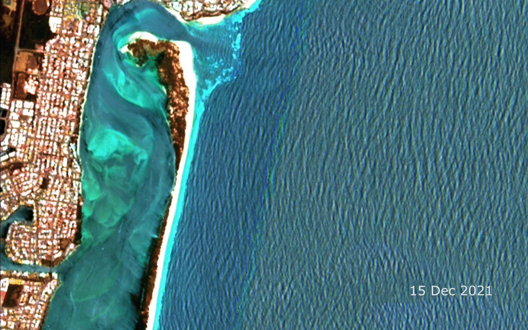
These before-and-after satellite images show the recent formation of a 300-m wide passage at the northern tip of Bribie Island, in southeast Queensland. The ‘before’ image was captured on December 15, 2021, and shows the island still intact. However, by January 09, 2022, waves have broken through a thin section of the island. The narrow dark brown strip of vegetation and white sandy beach has been replaced by a dark blue channel.
In these false-colour Sentinel-2 images, the water appears in various shades of blue and aqua, with lighter colours indicating shallow or more sediment-filled water. Vegetation appears brown, while the settlement of Golden Beach is visible on the left hand side of the images as bright white squares interspersed with brown. Between Golden Beach and Bribie Island is the submerged sand banks of Pumicestone Passage.
A natural process of change to the Queensland coastline
This breakthrough was a naturally occurring event in a dynamic coastal environment, according to the Queensland Department of Environment, Science and Innovation’s Principal Coastal Scientist. The final breakthrough occurred due to king tides, combined with large swells generated by Ex-Tropical Cyclone Seth that buffeted the island over the 2021–2022 New Year weekend.
Bribie Island formed by the movement of sand along the east coast of Australia over tens of thousands of years (Jones et al., 1978). This movement of sand, along with accretion and erosion, continues to shape the island. A large part of Bribie Island is included in the Bribie Island Recreation Area, managed by the Queensland Parks and Wildlife Service for the purposes of nature conservation and nature-based recreation.
The formation of Bribie Island has also influenced the creation of Pumicestone Passage, which separates Bribie Island from the Queensland mainland. Due to environmental diversity—seagrass meadows, sand islands, mud flats, mangroves, and significant species such as turtles, dugongs, and migratory shorebirds—Pumicestone Passage is part of the Moreton Bay Marine Park. It is also a declared Fish Habitat Area and a high-ecological-value waterway.
Technical details
The Sentinel-2 satellites have a combined revisit frequency of 5 days, providing the potential to capture phenomena as they occur. The images, captured on December 15, 2021, and January 09, 2022, although more than 5 days apart, were chosen for their low cloud cover. The images are displayed using spectral bands 12 (short wave infrared 2), 4 (visible red) and 2 (visible blue) in the red, green, and blue channels respectively. A contrast stretches of the spectral bands enhanced the substrate below the water and shows the water depth around the island.
The images were supplied by the European Space Agency and processed by the Queensland’s Remote Sensing Centre. The location of the image is marked by the red dot in the map of Queensland (right).
Reference
Jones, M., Hekel, H. and Searle, D.E. (1978) “Late quaternary sedimentation in Moreton Bay” Pap. Geology Department, University of Queensland, 8(2): pp 6-17.