June


About the Image
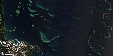
This image shows a section of the Coral Sea and Cape York, in far north Queensland. Shallow waters and coral reefs of the Great Barrier Reef appear in light blue, while deeper water is darker blue. Most of the heavily forested land surface is obscured by small, white rounded clouds. In the far east of the image, Raine Island (marked by a small grey box) is just visible as a brown speck of island and aqua lagoon. This island is approximately 130km due east of Cape York, and over 600km north-northwest of Cairns. While it may seem remote to humans, this island is the centre of the world for thousands of green turtles.
Raine Island Recovery
Since 1974, June 5 is celebrated as World Environment Day. The theme for 2021 is Reimagine, Recreate and Restore, an initiative focussed on reviving and restoring ecosystems to enhance livelihoods, counter climate change effects, and halt the decline in biodiversity. Raine Island is a perfect example of where this concept has been put into practice through a combination of reserve protection and active restoration activities.
Raine Island National Park (Scientific) is a unique and special coral cay on the outer edge of the Great Barrier Reef World Heritage Area. Green turtles have been nesting on Raine Island for over 1000 years, and it is the world’s largest remaining nesting population. It is also an important rookery for a range of seabirds and a known feeding ground for Tiger sharks which feed on the turtles, preferring the weakened or dead ones around the island. The island also has significant First Nations people and early European settlement cultural values. Unfortunately, changes in the island’s landscape led to the drowning of turtle eggs, as high tides reached farther up the shore, while adult females became trapped by rocky cliffs. Fortunately, the Raine Island Recovery Project has been working to reduce these risks and monitor the turtle population. A recent project used drones to count turtles more quickly and accurately, leading to a population estimate of over 64 000 turtles in late 2019.

Technical details
This Sentinel-2 image was captured at 10:50am on September 26th 2020. The image is displayed using spectral bands 4 (visible red), 3 (visible green) and 2 (visible blue) in the red, green and blue channels, respectively. The subtle-but-broad stripes visible in the image are due to the satellite sensor having multiple detectors with slightly different viewing angles. Where the satellite detector and light from the sun are at a particular angle, the sunlight reflects very strongly into the sensor – much like catching a bright flash from a highrise window at particular times on particular days during the year. This phenomenon, known as sunglint, is especially noticeable over sea surfaces. As the satellite detectors are slightly offset from each other, some will show high amounts of sunglint, while neighbouring sensors will show much less, leading to the striping pattern.
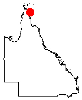
The image was supplied by the European Space Agency, and processed by the Queensland Government’s Remote Sensing Centre. The approximate location of the image is marked by the red dot in the map of Queensland (above right).


