Collections and services
The Museum of Lands, Mapping and Surveying was established in 1982. In 1988 we were officially recognised as a sub-branch of the Queensland Museum.
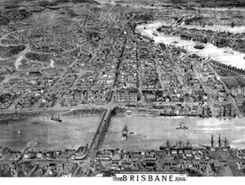
Land exploration and surveying have played a crucial role in the development of Queensland. Surveyors and cartographers played an active part in establishing Queensland's borders, physically surveying the land as well as creating maps, survey plans and registers.
Since it was established, the museum now holds one of the most comprehensive collections of its kind in the world. We acquire, preserve, catalogue and display materials and information pertaining to historical land settlement, surveying and cartographic activities in Queensland.
Collection focus
We acquire and preserve records, objects, maps and plans that are relevant to the history of mapping, surveying, and land administration in Queensland.
Acquisitions are assessed against the museum’s collection policy, with an emphasis on acquiring items which meet the following criteria:
- significance, such as association with an event, person, historical period or geographic area, or underpinning a biotechnological product
- well documented provenance
- capacity to be interpreted for exhibition and research
- stable physical condition
- transferable legal title.
Historical collections
Our physical and digital collections include:
- historical maps and plans
- historical photographs
- aerial photography
- historical objects
- biographies of surveyors and cartographers
- documents (e.g. early Queensland Treasury rental sheets)
- publications.
Note: We have made our best efforts to ensure that the information in the museum is interpreted correctly. Some of our historical information has been compiled from aged and potentially damaged documents. If you request a copy of an image, map or document the quality of copies will vary.
"Maps and charts intrude into the very fabric of peoples' lives, whether or not they are aware of it. Our society does not build, bury, move or plan, travel, navigate, teach, exploit, conserve or research without a map or chart." (Cartography, vol. 20, no. 2, December 1991).
Additional services
- Historical mapping and surveying objects for loan.
- Guided tours of the Museum of Lands, Mapping and Surveying—provided via appointment only.
- Presentations relating to the history of land, mapping and surveying in Queensland.
Connect with us
- Visit the Museum at 317 Edward Street, Brisbane.
- Subscribe to the LandQld Facebook page for updates on exhibits.