St Pauls (Moa)
Introduction
Moa is a part of the Torres Strait’s western island group and is the second largest island in the Torres Strait[1]. The Mualgal (Moo-al-gul) people, known locally as Italgal (Itu-gul), are the Traditional Owners of the island[2] and refer to their island as ‘Mua’. The English spelling of Mua is ‘Moa’.
The island is characterised by mounds of rock and is sparsely vegetated throughout. It is home to 2 communities: St Pauls and Kubin. St Pauls is located on the north-eastern side of the island at the base of Moa Peak, the highest peak in the Torres Strait[3]. Kubin is located on the southern end of the island. The communities are linked by a bitumen and gravel road.
History of St Pauls community
European contact
Captain William Bligh, in charge of the British Navy ships Providence and Assistant, visited the Torres Strait in 1792 and mapped the main reefs and channels. He named Moa ‘Banks Island’ in honour of his patron and friend, the botanist Sir Joseph Banks[4].
In the 1860s, beche-de-mer (sea cucumber) and pearling boats began working the reefs of the Torres Strait but few Europeans visited Moa Island before the 1870s. A small pearling station was established on Moa by John Gay between 1872 and 1875[5]. Recruiting local islander men, European beche-de-mer and pearling boats extensively worked the sea beds between the islands of Moa and Badu in the 1870s.
In 1872, the Queensland Government sought to extend its jurisdiction and requested the support of the British Government[6]. Letters Patent[7] were issued by the British Government in 1872 creating a new boundary for the colony which encompassed all islands within a 60 mile radius of the coast of mainland Queensland. This boundary was further extended by the Queensland Coast Islands Act 1879{8] and included the islands of Boigu, Darnley, Murray and Saibai, which lay beyond the previous 60 nautical mile limit. The new legislation enabled the Queensland Government to control and regulate bases for the beche-de-mer and pearling industries, which had previously operated outside its jurisdiction[9]. By 1884, two pearling stations were operating on Badu. One of the stations was owned by John Bell, who also ran stations on Jervis Island[10].
Torres Strait Islanders refer to the arrival of London Missionary Society (LMS) missionaries in July 1871 as ‘the Coming of the Light.’ Reverend A W Murray and William Wyatt Gill were the first LMS missionaries to visit Moa Island in October 1872. South Sea Islander lay preachers were appointed as teachers to work on the island the following month. These teachers established a mission settlement at Totalai on the northern side of the island; but by 1901 the settlement had been abandoned[11].
From 1863 to 1904, an estimated 55,000 to 62,500[12] South Sea Islander people were forcibly removed from more than 80 islands throughout the Pacific including Vanuatu and the Solomon Islands[13]. They were used to support Queensland’s growing sugar cane industry[14] and it is believed that some South Sea Islanders may have been persuaded or tricked into making the journey to Australia for employment[15]. It is also widely accepted that most were kidnapped for the purposes of slave labour in a process known as ‘blackbirding’[16].
During this period, South Sea Islanders were often subjected to extreme exploitation by employers and were not paid for their labour[17]; they ‘were effectively treated as slaves'[18].
The Queensland Government introduced the Polynesian Labourers Act 1868 and later the Pacific Labourers Act 1880 in an effort to prevent the kidnapping of South Sea Islanders. Under the new system, trade vessels were monitored and South Sea Islanders were able to enter into paid three-year contracts[19]. Wages were meagre, and exploitation continued[20].
By the 1900s, a small South Sea Islander population resided throughout the Torres Strait Islands. In 1904, tensions between the South Sea Islander and the Torres Strait Islander people of neighbouring Mabuiag Island resulted in 2 South Sea Islander families, the Ware and Namok families, leaving the island and moving to Moa Island[21]. The Ware family negotiated with Anu Namai, a Torres Strait Islander man from Moa Island, who allowed them to settle at the deserted village of Wug on the eastern side of the island. The Ware family was soon joined at Wug by the Namok family and other South Sea Islander families from Mabuiag and Saibai Islands[22].
On 20 May 1908, the Queensland Government formally gazetted 500 acres as a reserve for the benefit of South Sea Islander people on the eastern side of Moa Island[23]. With the encouragement of Hugh Milman, the government resident at Thursday Island,in 1908 the Anglican Church founded a mission specifically for South Sea Islander families on the reserve land at Moa Island. At the time, the Anglican Church also ran a South Sea Islanders’ Home on Thursday Island. Milman suggested that the new mission should be named St Pauls, after the famous cathedral in London[24].
The first missionary appointed to St Pauls was Deaconess Florence Buchanan. She arrived at Moa Island on 19 May 1908 and was assisted in her work by Joe and Florence Bann from Fiji. In 1908, a census reported that South Seas Islanders were ‘scattered through the different islands, and some 30 have taken advantage of the reserve and settled there’[25].
Florence Buchanan organised the establishment of a mission school and purchased a ketch named the Banzai to transport goods and mail to the mission from Thursday Island[26]. In November 1912, 36,000 acres of land on Moa Island were officially gazetted as an Aboriginal reserve by the Queensland Government, exclusive of the land already gazetted for the South Sea Islanders. Many other Torres Strait Islands were gazetted as Aboriginal reserves at the same time[27].
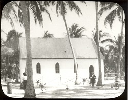
The first church at St Pauls was opened in 1913 and the Anglican Church established a missionary training college at St Pauls in February 1917[28]. Reverend JW Schomberg was appointed superintendent of St Pauls in 1921. He began an extensive building program at the mission including housing, a new college and church, a hostel for girls and concrete wells to improve the settlement’s water supply. Schomberg was an excellent photographer and his many photographs of the mission taken during the 1920s and 1930s provide a detailed pictorial history of the settlement[29].
During the time of his leadership, the St Pauls community established 2 co-operative businesses: the Moa Fishing Company and the Banks Pearling Company. Many St Pauls men also worked as divers and crew on board Japanese-captained pearl luggers during the 1920s and 1930s[30].
In 1936, around 70% of the Torres Strait Islander workforce went on strike in the first organised challenge against government authority made by Torres Strait Islanders. The nine-month strike was an expression of Islanders’ anger and resentment at increasing government control of their livelihoods. The strike was a protest against government interference in wages, trade and commerce and also called for the lifting of evening curfews, the removal of the permit system for inter-island travel and the recognition of the Islanders’ right to recruit their own boat crews[31].
The strike produced a number of significant reforms and innovations. Unpopular local Protector J D McLean was removed and replaced by Cornelius O’Leary who established a system of regular consultations with elected Islander council representatives. The new island councils were given a degree of autonomy, including control over local island police and courts[32].
On 23 August 1937, O’Leary convened the first Inter Islander Councillors Conference at Yorke Island. Representatives from 14 Torres Strait communities attended the conference. After lengthy discussions, unpopular bylaws (including the evening curfews) were cancelled, and a new code of local representation was agreed upon[33]. In 1939, the Queensland Government passed the Torres Strait Islanders Act 1939 which incorporated many of the recommendations discussed at the conference. A key section of the new act officially recognised Torres Strait Islanders as a separate people from Aboriginal Australians[34].
During World War Two, the Australian Government recruited Torres Strait Islander men to serve in the armed forces. Enlisted men from Moa and other island communities formed the Torres Strait Light Infantry. While the Torres Strait Light Infantry were respected as soldiers, they only received one third the pay given to white Australian servicemen.
On 31 December 1943, members of the Torres Strait Light Infantry went on strike calling for equal pay and rights for all. The Australian Government agreed to increase their pay to two thirds the level received by white servicemen. Full back pay was offered in compensation to the Torres Strait servicemen by the government in the 1980s[35].
Before World War Two, the mineral wolfram was discovered on Moa Island (in the 1930s) and members of the St Pauls and Kubin communities began mining wolfram in 1938. During the 1950s and 1960s, a Christian co-operative ran mining operations on the island. All mining activity ceased on the island in 1973, when the price of the mineral dropped on world markets[36].
After gaining independence from Australia in 1975, Papua New Guinea asserted its right to the islands and waters of the Torres Straits. In December 1978 a treaty was signed by the Australian and Papua New Guinea Governments that described the boundaries between the 2 countries and the use of the sea area by both parties[37].
Local government and Deed of Grant In Trust communities
In 1984, the Anglican Bishop of Carpentaria and the Director of Torres Strait Islander Affairs relinquished their trusteeship of St Pauls Mission reserve and passed responsibility for the management of St Pauls to an elected council[38].
On 30 March 1985, the St Pauls community elected 3 councillors to constitute an autonomous St Pauls Island Council, established under the Community Services (Torres Strait) Act 1984. The Act conferred local government type powers and responsibilities upon Torres Strait Islander councils for the first time. The council area, previously an Aboriginal reserve, was transferred on 21 October 1985 to the trusteeship of the council under a Deed of Grant in Trust[39].
In 2007, the Local Government Reform Commission recommended that the 15 Torres Strait Island councils be abolished and the Torres Strait Island Regional Council be established in their place. The first Torres Strait Island Regional Council was elected on 15 March 2008[40].
End notes
- Australia, Torres Strait Regional Authority, Community Profile: Moa – Kubin <https://www.tsra.gov.au/the-torres-strait/community-profiles/st-pauls-moa-island> at 1 February 2013.
- Mualgal People v Queensland [1999] FCA 157; Nona and Manas v State of Queensland [2006] FCA 412.
- Queensland, Torres Strait Island Regional Council Community Profile: St Pauls <http://www.tsirc.qld.gov.au/communities/moa-st-pauls-community> at 12 February 2013.
- M Flinders, A Voyage to Terra Australis, (W Bulmer and Co, London; 1814) A Shnukal, ‘Historical Mua’ (2008) vol.4, 2, Memoirs of the Queensland Museum, Cultural Heritage Series, 186-187.
- S Mullins, Torres Strait, A History of Colonial Occupation and Culture Contact 1864-1897 (Central Queensland University Press, Rockhampton; 1994) 163; A Shnukal, above n 4, 188-191.
- S B Kaye, Jurisdictional Patchwork: Law of the Sea and Native Title Issues in the Torres Strait (2001) 2, Melbourne Journal of International Law, 1.
- Queensland Statutes (1963) vol.2, 712.
- See also Colonial Boundaries Act 1895 (Imp); Wacando v Commonwealth (1981) 148 CLR 1.
- Mullins, above n 5, 139-161.
- R Ganter, The Pearl Shellers of Torres Strait (Melbourne University Press, Melbourne, 1994) 65, 246.
- S Mullins, Above n5, 121; A Shnukal, Above n4,192-195.
- Australian Human Rights Commission – Australian South Sea Islanders A century of race discrimination under Australian law, http://www.humanrights.gov.au/erace-archives-australian-south-sea-islanders#1 at 31 May 2013.
- Many South Sea Islander people were also removed from Kiribati and Tuvalu.
- Queensland, Department of Aboriginal and Torres Strait Islander Partnerships, Australian South Sea Islander Community History, http://www.datsima.qld.gov.au/resources/multicultural/community/australian-south-sea-islanders/history.pdf at 30 May 2013.
- Ibid.
- Ibid.
- AHRC, above n 12.
- Ibid.
- Ibid.
- Ibid.
- A Shnukal, above n 4, 229-231.
- T Hall Matthews, From Village to Mission then Community, Celebrating the Centenary of St. Paul’s – Mua Island (Carpentaria Consulting Services, Yungaburra; 2004)10-14; A Shnukal, Above n4, 237.
- Initially 500 acres was gazetted for the reserve but this was increased to 2000 acres in 1909, Queensland, Queensland Government Gazette, 1908 (1909) vol.1, 1303; Queensland, Annual Report of the Chief Protector of Aboriginals for 1908 (1909) 24; Queensland, Annual Report of the Chief Protector of Aboriginals for 1909 (1910) 19.
- T Hall-Matthews, Above n22, 16-17.
- T Hall-Matthews, Above n22, 17.
- T Hall-Matthews, Above n22, 17-19.
- Queensland, Queensland Government Gazette, vol.99, no.138 (1912) 1330.
- T Hall-Matthews, Above n22, 21-22, 26-29.
- The Reverend Schomberg’s photographs are now kept by the Australian Institute of Aboriginal & Torres Strait Islander Studies (AIATSIS) in Canberra; N Schomberg, ‘Baba Schomberg’s Photographs of Mua, 1921-1935 (2008) vol.4, 2, Memoirs of the Queensland Museum, Cultural Heritage Series, 331-347; T Hall-Matthews, Above n22, 30-31.
- A Shnukal, ‘Above n4, 238-240; T Hall-Matthews, , 25.
- N Sharp, Stars of Tagai, The Torres Strait Islanders (Aboriginal Studies Press, Canberra; 1993) 181-186, 278; J Beckett, Torres Strait Islanders: Custom and Colonialism (Cambridge University Press, Cambridge; 1987) 54.
- J Beckett, Above n31, 54-55.
- N Sharp, Above n31, 210-214; Queensland State Archives, A/3941 Minutes of Torres Strait Councillors Conference held at Yorke Island 23-25 August 1937.
- Queensland, Annual Report of the Department of Native Affairs for 1939 (1940) 1; N Sharp, Stars of Tagai, 214-216.
- J Beckett, Above n31, 64-65; Australian War Memorial website, Wartime Issue 12 ‘One Ilan Man’, http://www.awm.gov.au/wartime/12/article.
- Queensland, Annual Report of the Department of Native Affairs for 1939 (1940) 4; N Sharp, Stars of Tagai, 169-170; A Shnukal, ‘Wolfram Mining and the Christian Co-operative Movement’ (2008) vol.4, 2, Memoirs of the Queensland Museum, Cultural Heritage Series, 349-383.
- The treaty included a special provision that allowed for free movement (without passports or visas) between both countries for traditional activities such as fishing, trading and family gatherings. These activities occur in a specifically created Protected Zone and nearby areas. The Protected Zone also assists in the preservation and protection of the land, sea, air and native plant and animal life of the Torres Strait. For further information visit the Department of Foreign Affairs and Trade website: https://www.dfat.gov.au/geo/torres-strait/Pages/the-torres-strait-treaty; N Sharp, Stars of Tagai, 226-227.
- T Hall-Matthews, Above n22, 48.
- Queensland, Annual Report of the Department of Community Services for 1986 (1987) 3; Queensland, Annual Report of the Department of Community Services for 1987 (1988) 29.
- In the elections conducted under the Local Government Act 1993 members of the 15 communities comprising the TSIRC local government area each voted for a local councillor and a Mayor to constitute a council consisting of 15 councillors plus a mayor.