Sarina
Introduction
Sarina is located 37km south of Mackay at Plane Creek in the foothills of the Connors Range. The town’s sugar mill and coal loading facilities, as well as tourism, help to support the economy in Sarina. The Wiri, Barada Barna Kabalbara and Yetimarla, Yuibera, Birri-Gubba and Kungalburra peoples all have strong associations with the Sarina area; however, no determination of native title has been made over the area. The Aboriginal language name for the Sarina/Plane Creek area is ‘Ilbilbie’[1].
History of Sarina
European Contact
Captain James Cook in command of HM Endeavour sailed past the coastline between Sarina and Mackay on 31 May 1770, naming Cape Palmerstone and Slade Point. The crew of the Endeavour did not land in the area, but witnessed plumes of smoke lit by local Aboriginal people and observed their use of outrigger canoes[2]. A more detailed survey of the coastline near Sarina was made by Captain Francis Blackwood in charge of HMS Fly in 1843. A party from the Fly landed at West Hill and Armstrong’s Beach and walked to Sarina Inlet[3].
The first European settlers to reach the greater Mackay area were the members of John Mackay and John McCrossin’s expedition in 1860. The expedition travelled north from Rockhampton via an inland route, until they reached the watershed of the Isaac River. The expedition then turned eastwards and reached the Pioneer River area in May 1860. John Mackay established a pastoral run in the district, named Greenmount, in January 1862 but was forced to sell out after less than 2 years. A township established near Greenmount was named Mackay in his honour in 1863[4].
The pastoralists John and Edmund Atherton and their brother-in-law Henry Bell were the first European settlers to reach the Sarina area in 1864. The Atherton brothers and Henry Bell blazed a trail north from Rockhampton and initially took up a pastoral run at West Hill, located between St Lawrence and Mackay. Aboriginal resistance at West Hill was so fierce that the Atherton brothers and Bell made the decision to abandon West Hill and continue north to Plane Creek. Henry Bell and Edmund Atherton went into partnership and established the Plane Creek pastoral run in 1864. Plane Creek station covered an area of approximately 25 square miles, including the entire Plane Creek valley[5].
Following the establishment of Greenmount and Plane Creek pastoral stations, new parties of pastoralists and farmers arrived in the Mackay region, taking up runs and blocks of land throughout the 1860s. Aboriginal people resisted the invasion of their lands by the settlers, and wide spread frontier violence occurred across the greater Mackay district during the 1860s and 1870s. Native Police barracks were established at Marlborough in 1866 and Bloomsbury, just north of Mackay, in 1868[6]. The use of mounted Native Police was instrumental in crushing local Aboriginal resistance[7].
The process of European settlement had a devastating impact on the Aboriginal people of the region. In 1870, G F Bridgman became the manager of Homebush station, located between Mackay and Plane Creek station. Bridgman observed that large numbers of Aboriginal people had taken shelter at Homebush station, and began a campaign to establish an Aboriginal reserve in the area. Responding to his campaign the Queensland government set aside an area of 14,080 acres as an Aboriginal reserve near the Cape Palmerstone and Homebush pastoral runs in 1871[8].
Bridgman believed that more needed to be done and, in 1873, organised a petition calling for the government to allocate funding to encourage Aboriginal people to settle on the reserve and educate them to adapt themselves to making an honest living by work[9]. The government agreed to provide funding and appointed four trustees, including Bridgman, to manage the reserve. Local property owners, including Edmund Atherton and Henry Bell at Plane Creek station, supported the project, believing the reserve had the potential to supply their properties with an Aboriginal workforce[10].
Under Bridgman’s leadership, housing, stores and a school were established on the reserve. Crops were planted and Aboriginal men were hired out to local employers as labourers and station hands[11]. In 1875 and 1878, government amendments to the description of the reserve reduced its area to 10,000 acres[12]. After the election of a new government in 1879, all funding to the reserve was cut, forcing the closure of the school. In the same year, 90% of the reserve land was revoked and opened for settlement, forcing the Aboriginal residents to move away from the area[13].
Aboriginal missions which operated in the greater Mackay region included a Catholic mission and orphanage, administered by Father Bucas and the Sisters of Mercy order during the 1870s and 1880s[14]. An Aboriginal mission at Marie Yamba, to the north of Mackay, was administered by the Lutheran Church between 1887 and 1902[15].
In 1897, the Queensland Government passed the Aboriginals Protection and Restriction of the Sale of Opium Act 1897. Under this Act and subsequent Aboriginal Protection Acts, the government appointed local protectors to districts across Queensland including Mackay. Protectors exercised control over Aboriginal labour and savings accounts and were authorised to remove Aboriginal people to reserves and missions across Queensland[16]. Between the years 1898 and 1967, there were 72 documented removals of Aboriginal people from the Mackay district by the Queensland Government. Most were removed to the reserves and missions at Yarrabah, Barambah (now Cherbourg), Woorabinda and Palm Island[17].
Sugar cane plantations were established in the greater Mackay district in the late 1860s. Large numbers of South Sea Islanders were brought from the Islands of the South Pacific to the Mackay region to work on the cane fields[18]. Sugar became an important crop in the Plane Creek area during the 1880s. In 1894, a group of farmers, which included the pioneer settlers Edmund Atherton and Henry Bell, organised the establishment of the Plane Creek Central Mill Company. With the assistance of a government loan, a sugar mill was constructed at Plane Creek, which began crushing sugar cane in November 1896[19]. A distillery for industrial alcohol began production at Sarina in 1926[20].
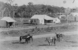
In the late 19th century, a small township was built at Plane Creek centred on Michelmore's Hill. Over time, the township grew and spread down to meet the sugar mill, located on the banks of the creek. By 1904, the town had begun to develop with stores, hotels, a police station, banks, butcheries and a post office all being built. The town, named Sarina, officially came into being on 2 September 1907[19]. The town took its name from Sarina Inlet, a coastal location situated about 8km east of the town, originally named by the surveyor William Wilson in 1869. The original source of inspiration for Wilson's naming of the inlet has not been recorded[22].
The Plane Creek sugar mill and industrial alcohol distillery at Sarina were taken over by Pioneer Sugar Mills in July 1974. Ownership of the mill was transferred to CSR in 1987. CSR changed the name of its sugar mill operations to Sucrogen in March 2010, and announced it was selling Sucrogen to a Singapore-listed agribusiness named Wilmar International Ltd in July 2010[23]. Other significant industries in the Sarina area include tourism, and coal loading facilities at Hay Point and Dalrymple Bay, which opened in the 1970s[24].
End notes
- P Phillips, Sarina Shire in Retrospect (Sarina Bi-Centennial Committee, Sarina; 1988) 25.
- K W Kennedy, Mackay Revisited (Mackay City Council, Mackay; 2002) 5.
- Phillips, above n 1, 8-9.
- Kennedy, above n 2, 8-34; J.A Nillson, Mackay, John (1839-1914) (Australian Dictionary of Biography, 2013) http://adb.anu.edu.au/biography/mackay-john-4106 at 12 April 2013.
- Mackay Family History Society, Early Settlers of Mackay 1860-1885 (Mackay Family History Society, Mackay; 2009) 44-47; Phillips, above n 1, 23-27, 30-31; L Atherton, Atherton, John (1837-1913) (Australian Dictionary of Biography, 2013) http://adb.anu.edu.au/biography/atherton-john-2907 at 12 April 2013.
- C Moore, ‘Blackgin’s Leap: A Window into Aboriginal-European Relations in the Pioneer Valley, Queensland in the 1860s’ (1990) 14, 1-2 Aboriginal History, 61-79; R Evans, ‘Queensland’s First Aboriginal Reserve, Part 1: The Promise of Reform’ (1971) 2, 4 Queensland Heritage, 26-27; Kennedy, above n 4, 35-56.
- Ibid.
- Evans, above n 6, 28; Queensland, Queensland Government Gazette, 1 July 1871, 951.
- Evans, above n 6, 28.
- Evans, above n 6, 28-30; Author unknown, ‘Treatment of the Aborigines’, The Brisbane Courier, 31 May 1875, 3.
- G Bridgman, ‘Report on the Mackay Reserve’ (1878) 2 Votes & Proceedings of the Queensland Parliament, 60; Author unknown, ‘The Bright Side of Life amongst the Aborigines in the Mackay District’, The Brisbane Courier, 5 February 1876, 2.
- Queensland, Queensland Government Gazette, 20 March 1875, 626; Queensland, Queensland Government Gazette, 5 January 1878, 16.
- R Evans, ‘Queensland’s First Aboriginal Reserve, Part 2: The Failure of Reform’ (1971) 2, 5 Queensland Heritage, 8; Author unknown, ‘The Brisbane Courier’, The Brisbane Courier, 15 April 1879, 2; Occasional Correspondent, ‘Settlement in the Mackay District’, The Queenslander, 27 December 1879, 819.
- J Maguire, ‘Catholic Missions to the Aborigines in North Queensland’ (James Cook University, 1984) 4 Lectures on North Queensland History, 54-72; Moore, above n 6, 63.
- R Ganter, Mari Yamba (1887-1902) (Griffith University, date unknown) http://missionaries.griffith.edu.au/qld-mission/mari-yamba-1887-1902 at 12 April 2013.
- R Kidd, The Way We Civilise (University of Queensland Press, St. Lucia; 2005) 47-48.
- Department of Aboriginal and Torres Strait Islander Partnerships, Community and Personal Histories Removals Database (access restricted).
- C Moore, Kanaka: A History of Melanesian Mackay (Institute of Papua New Guinea and University of Papua New Guinea Press, Port Moresby; 1985); Phillips, above n 1, 56-58.
- Phillips, above n 1, 71-75; Author unknown, Title unknown, The Queenslander, 6 March 1880, 315.
- B Wright and L. Clarke, Looking Back & Moving Forward, A Brief History of Mackay Regional Council (Mackay Regional Council, Mackay; 2008) 8.
- Phillips, above n 1, 14-19.
- Queensland Government, Place names details (Department of natural Resources and Mines, 2013) https://www.dnrm.qld.gov.au/mapping-data/place-names/search/queensland-place-names-search at 12 April 2013.
- Phillips, above n 1, 74.
- Phillips, above n 1, 19.