Saibai
Introduction
Saibai is part of the north-western island group of Torres Strait, which consists of Saibai, Dauan and Boigu islands. Saibai lies approximately 5km off the coast of New Guinea and is approximately 20km long and 6km wide[1]. The island is an average of 1m above sea level and consists largely of mangrove fringe, flood plain and brackish swamps. The island is vulnerable to flooding and rising sea levels, particularly during the wet season when around 2m of water regularly falls onto the island. During the dry season however, the island experiences drought-like conditions.
The original inhabitants of Saibai are the Koeybuway (Ker-bu-y) and Moegibuway (Migi-bu-y) peoples and they are acknowledged as the Traditional Owners of Saibai[2]. They are of Melanesian origin and lived in village communities following traditional patterns of hunting, fishing, agriculture and trade for many thousands of years before contact was made with the first European visitors to the region. Strong kinship and trade ties exist between the people of Saibai, Mt Cornwallis and Boigu Islands and coastal Papuan communities[3].
There are now 2 main population centres on Saibai: Saibai Village in the northwest and Churum in the south-west.
History of Saibai
European contact
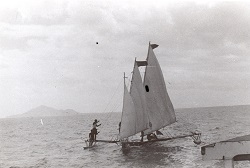
In the 1860s, beche-de-mer (sea cucumber) and pearling boats began working the reefs of Torres Strait. The first European to visit Saibai was probably a beche-de-mer operator named John Delargy, who visited the island with his South Sea Islander crew in 1869 while searching for a lost whaleboat. Delargy established friendly relations with the people of Saibai, trading goods and sharing a feast with the Islanders. Pearling bases were never established on Saibai but in the 1870s European pearl and beche-de-mer operators began recruiting men from Saibai to work on their luggers[4].
Torres Strait Islanders refer to the arrival of London Missionary Society (LMS) missionaries at Erub in July 1871 as ‘the Coming of the Light.’ After visiting Darnley Island and Tudu, the LMS missionaries led by Rev. Samuel McFarlane and Reverend A.W. Murray travelled to Mt Cornwallis and Saibai islands. Two South Sea Islander lay pastors named Josaia and Sivene were appointed to work as missionary teachers at Mt Cornwallis and Saibai. LMS missionaries revisited Mt Cornwallis and Saibai in 1872 and found that Josaia and Sivene had been accepted by the Islanders and given land by the local chiefs[5]. However, increased contact with the outside world brought new diseases to the islands and, during the 1870s, a measles epidemic significantly reduced the population of Saibai.
In 1872, the Queensland Government sought to extend its jurisdiction and requested the support of the British Government[6]. Letters Patent[7] were issued by the British government in 1872 creating a new boundary for the colony which encompassed all islands within a 60 nautical mile radius of the coast of Queensland. This boundary was further extended to 96km by the Queensland Coast Islands Act 1879 (Qld)[8] and included the islands of Boigu, Darnley, Murray and Saibai, which lay beyond the previous 60 nautical mile limit. The new legislation enabled the Queensland Government to control and regulate bases for the beche-de-mer and pearling industries, which previously had operated outside its jurisdiction[9].
From the late 1870s onwards, the coastal communities of Papua and the islands of Saibai, Boigu and Mt Cornwallis were raided by warriors of the Marind-Anim or Tugeri people from Dutch-controlled West Papua. A retaliatory expedition led by British officials based in Daru in 1896 diminished the threat of the Marind-Anim but sporadic raids on Saibai, Boigu and Mt Cornwallis islands and Papua continued well into the 1920s[11].
The English scientist and anthropologist Alfred Cort Haddon first visited the Torres Straits in 1888. Haddon originally came to the Torres Straits to study the coral reefs but soon became fascinated by the traditional culture and way of life of the Torres Strait Islander people. Haddon returned to the Torres Straits in 1898 with the Cambridge University anthropological expedition. The Cambridge expedition spent 7 months in the Torres Straits including a stay at Saibai, documenting the Torres Strait Islander people and their culture. The expedition collected artefacts, took down genealogies, re-created ceremonies and used wax cylinders and early movie cameras to make the first sound recordings and films in the Torres Strait[12].
Over time, the Queensland Government began to exert more influence on the lives of Torres Strait Islander people. John Douglas, the government Resident at Thursday Island, initially shielded Torres Strait Islanders from the controlling provisions of the Aboriginal Protection and Restriction of the Sale of Opium Act 1897. After Douglas passed away in 1904, the administration that followed began to assert control over Torres Strait Islander labour and savings accounts and imposed restrictions on Islander movement to and from the mainland[13].
In November 1912, an area of 35,000 acres of land on Saibai was officially gazetted as an Aboriginal reserve by the Queensland Government. Many other Torres Strait Islands were gazetted as Aboriginal reserves at the same time[14]. Shortages of food on Saibai were mentioned in a government report dating from 1912[15]. Between 1914 and 1918, a religious movement known as ‘German Wislin’ emerged on Saibai. The Wislin believers predicted that the Germans would win World War One and reward the people of Saibai with a cargo of gifts which would be brought to the island by steamer. After Britain and her allies defeated Germany in 1918, the Wislin movement died away[16].
During the 1920s and 1930s racial legislation was strictly applied to Torres Strait Islanders enabling the government to remove Islanders to reserves and mission across Queensland. A small number of documented removals from Saibai occurred between 1909 and 1941: 2 people were removed to Palm Island and 1 person was taken to Yarrabah[17].
In 1936, around 70% of the Torres Strait Islander workforce went on strike in the first organised challenge against government authority made by Torres Strait Islanders. The nine-month strike was an expression of Islanders’ anger and resentment at increasing government control of their livelihoods. The strike was a protest against government interference in wages, trade and commerce and also called for the lifting of evening curfews, the removal of the permit system for inter-island travel and the recognition of Islanders’ right to recruit their own boat crews[18]. Three men were gaoled on Saibai in 1936 by the authorities after strike protests occurred on the island[19].
The strike produced a number of significant reforms and innovations. Unpopular local Protector J D McLean was removed and replaced by Cornelius O’Leary who established a system of regular consultations with elected Islander council representatives. The new Island councils were given a degree of autonomy, including control over local police and courts[20].
On 23 August 1937, O’Leary convened the first Inter Islander Councillors Conference at Masig. Representatives from 14 Torres Strait communities attended the conference. Namabai Atu, Mareko, Soki and Enosa represented Saibai at the conference. After lengthy discussions, unpopular bylaws (including the evening curfews) were cancelled and a new code of local representation was agreed upon[21]. In 1939, the Queensland Government passed the Torres Strait Islander Act 1939, which incorporated many of the recommendations discussed at the conference. A key section of the new act officially recognised Torres Strait Islanders as a separate people from Aboriginal Australians[22].
During World War Two, the Australian Government recruited Torres Strait Islander men to serve in the armed forces. Enlisted men from Saibai and other island communities formed the Torres Strait Light Infantry. While the Torres Strait Light Infantry were respected as soldiers, they only received one third of the pay given to white Australian servicemen.
On 31 December 1943, members of the Torres Strait Light Infantry went on strike calling for equal pay and equal rights[23]. The Australian Government agreed to increase their pay to two thirds the level received by white servicemen. Full back pay was offered in compensation to the Torres Strait servicemen by the Australian Government in the 1980s[24].
At the end of World War Two, the Queensland Government introduced measures to compensate Torres Strait Islanders for their contribution to the war effort and to populate the north as a defence against foreign invasion[25]. After the war, enlisted Torres Strait Islander men from Saibai, Boigu and Mt Cornwallis islands also discussed the possibility of developing a community on the mainland. Saibai elder, Bamaga Ginau, supported the proposal.
In 1947, king tides caused serious damage to properties and gardens across Saibai. Bamaga Ginau called a meeting regarding the future of Saibai and after much discussion a number of families made the decision to leave Saibai and move to the mainland[26].
The first families left Saibai on the pearl luggers Millard and Macoy and arrived at Muttee Heads in June 1947, where they established a temporary settlement in abandoned army facilities[27]. In July 1948, the Queensland Government gazetted 44,500 acres extending from Red Island Point to Kennedy Inlet and the Cowal Creek mission, as a reserve for the use of the Torres Strait Islanders[28].
In 1948, Mugai Elu and Tumena Sagaukaz left Saibai with their families and moved to Red Island Point. The Islanders at Muttee Heads relocated to a new settlement inland from Red Island Point in 1952. The new settlement was named Bamaga in honour of the leader of the migration, Bamaga Ginau. The smaller community at Red Island Point changed its name to Seisia in 1977[29].
After gaining its independence from Australia in 1975, Papua New Guinea asserted its right to the islands and waters of the Torres Straits. In December 1978, a treaty was signed by the Australian and Papua New Guinea governments that described the boundaries between the 2 countries and the use of the sea area by both parties[30]. The Torres Strait Treaty, which operated from February 1985, contains special provision for free movement (without passports or visas) between both countries[31]. There is constant traffic throughout the year between Saibai and Papua New Guinea. Free movement between communities applies to traditional activities, such as fishing, trading and family gatherings, which occur in a specifically created Protected Zone and nearby areas[32]. The Protected Zone also assists in the preservation and protection of the land, sea, air and native plant and animal life of the Torres Strait[33].
Local government and Deed of Grant in Trust communities
On 30 March 1985, the Saibai community elected three councillors to constitute an autonomous Saibai Council established under the Community Services (Torres Strait) Act 1984. This Act conferred local government type powers and responsibilities upon Torres Strait Islander councils for the first time. The council area, previously an Aboriginal reserve held by the Queensland Government, was transferred on 21 October 1985 to the trusteeship of the council under a Deed of Grant in Trust[34].
In March 2000, the elections for the Saibai Council were conducted on a clan basis. Seven councillors were elected to represent each of the 7 traditional clans. Each clan elected its own councillor. This system of representation has been maintained for the Saibai community forum.
In 2007, the Local Government Reform Commission recommended that the 15 Torres Strait Island councils be abolished and the Torres Strait Island Regional Council (TSIRC) be established in their place. In elections conducted under the Local Government Act 1993 on 15 March 2008, members of the 15 communities comprising the TSIRC local government area each voted for a local councillor and a mayor to constitute a council consisting of 15 councillors plus a mayor[35].
End notes
- Australia, Torres Strait Island Regional Authority Community Profiles: Saibai Island <https://www.tsra.gov.au/the-torres-strait/community-profiles/saibai-island> at 12 February 2013.
- In the case of Saibai People v Queensland (1999) FCA 158, the courts found that ‘(n)ative title exists in relation to the determination area, that is, the land and inland waters of Saibai, Mawalmay Thoera Island, Thawpay Kawamag Island and Kuykuthal Kawamag Island on the landward side of the high water mark.’ See also Victor Nona, John Whop, Pili Waigana, Nelson Gibuma and Phillip Bigie on behalf of the Saibai, Dauan, Mabuiag, Badu and Boigu Peoples v The State of Queensland and Ors (2000) FCA 1118.
- R E Johannes & J W MacFarlane, Traditional Fishing in the Torres Strait Islands (CSIRO; 1991) 157-162, 168-170; J Singe, The Torres Strait, People and History (University of Queensland Press, St Lucia; 1979) 174-179.
- S Mullins, Torres Strait, A History of Colonial Occupation and Culture Contact 1864-1897 (Central Queensland University Press, Rockhampton; 1994) 65; Australia, Torres Strait Regional Authority, ‘Saibai Profile’, https://www.tsra.gov.au/the-torres-strait/community-profiles/saibai-island.
- S Mullins, above n4 121; J Singe, above n3, 179-182.
- S B Kaye, Jurisdictional Patchwork: Law of the Sea and Native Title Issues in the Torres Strait (2001) 2, Melbourne Journal of International Law.
- Queensland, Queensland Statutes (1963) vol.2, 712.
- See also Colonial Boundaries Act 1895 (Imp); Wacando v Commonwealth (1981) 148 CLR 1.
- S Mullins, above n4, 139-161.
- Queensland State Archives, Colonial Secretary’s Correspondence, COL/A305, 1881/154, report on the cruise of the 'Pearl' to Cornwallis Island.
- S Mullins, above n4, 146-148; J Singe, above n3, 74-76, 83.
- Australian Dictionary of Biography website, entry for Alfred Cort Haddon, http://adb.anu.edu.au/biography/haddon-alfred-cort-10386; D Moore, The Torres Strait Collections of A. C. Haddon (Cambridge University Press, Cambridge, 1984) 10-12.
- J Beckett, Torres Strait Islanders: Custom and Colonialism (Cambridge University Press, Cambridge; 1987) 45-47.
- Queensland, Queensland Government Gazette, vol.99, no.138 (1912) 1330.
- Queensland, Annual Report of the Chief Protector of Aboriginals for 1912 (193) 26.
- N Sharp, Stars of Tagai, The Torres Strait Islanders (Aboriginal Studies Press, Canberra; 1993) 117-118; J Singe, above n3, 183-184.
- Queensland, Department of Aboriginal and Torres Strait Islander Partnerships, Community and Personal Histories Removals Database.
- N Sharp, above n16, 181-186, 278; J Beckett, above n13, 54.
- N Sharp, above n16, 191-192.
- J Beckett, above n13, 54-55.
- N Sharp, above n16, 210-214; Queensland State Archives, A/3941 Minutes of Torres Strait Councillors Conference held at Yorke Island 23-25 August 1937.
- Sections 3 (a) – (c) of the Torres Strait Islander Act (Qld) 1939. See also: Queensland, Annual Report of the Department of Native Affairs for 1939 (1940) 1; N Sharp, above n16, 214-216.
- Australian War Memorial website, Wartime Issue 12 ‘One Ilan Man’, http://www.awm.gov.au/wartime/12/article.
- J Beckett, above n13, 64-65; Australian War Memorial website, Wartime Issue 12 ‘One Ilan Man’, http://www.awm.gov.au/wartime/12/article; Boigu Community Council, Boigu, Our Culture and History, 89-100.
- D Ober, J Sproats & R Mitchell, Saibai to Bamaga, The Migration from Saibai to Bamaga on the Cape York Peninsula (Bamaga Island Council Joe Sproats and Associates, Townsville; 2000) 14; Queensland State Archives, Director of Native Affairs correspondence, SRS 505/1, 9M/10, Development of Northern Peninsula Area.
- D Ober et al, above n25, 6-8; Queensland, Annual Report of the Department of Native Affairs for 1948 (1949 22.
- D Ober et al, above n25, 16-17.
- Queensland, Annual Report of the Department of Native Affairs for 1949 (1950) 25; Queensland, Queensland Government Gazette, 24 July 1948, 675.
- The name Seisia is derived from the first letters of the names of Mugai Elu’s father and brothers - Sunai, Elu, Ibuai, Sagaukaz, Isua and Aken, Queensland, Queensland Placenames Database, Department of Environment & Resource Management, https://www.dnrm.qld.gov.au/mapping-data/place-names/search/queensland-place-names-search.
- For further information see: Australia, Department of Foreign Affairs and Trade, https://www.dfat.gov.au/geo/torres-strait/Pages/the-torres-strait-treaty; Sharp, 226-227.
- Under Art. 11.
- See also Art 12.
- Further information about the Protected Zone can be found at: http://www.pzja.gov.au/.
- Queensland, Annual Report of the Department of Community Services for 1986 (1987) 3; Queensland, Annual Report of the Department of Community Services for 1987 (1988) 29.
- In the elections conducted under the Local Government Act 1993 members of the 15 communities comprising the TSIRC local government area each voted for a local councillor and a Mayor to constitute a council consisting of 15 councillors plus a mayor.