Ride the Veloway 1
The Veloway 1 provides a safe route for people to ride bikes and personal mobility devices like e-scooters between the Brisbane CBD and Brisbane's southside.
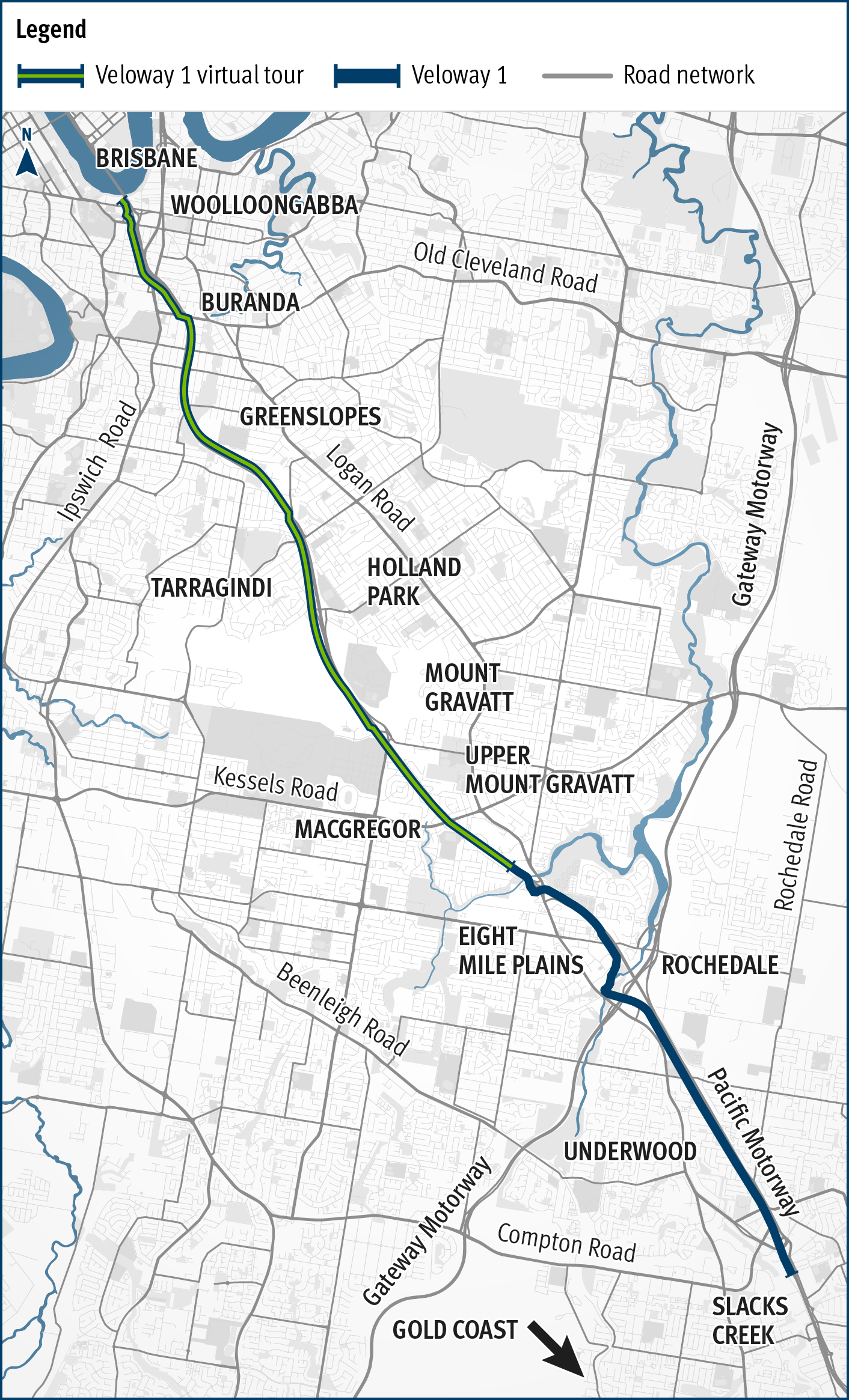
This 20km, 3m wide bikeway runs along the Pacific Motorway from South Brisbane to Slacks Creek*. It provides a direct and convenient way to commute to Brisbane CBD by bicycle or e-scooter. With lots of access points, it's also safe and convenient for you to ride to different destinations along the bikeway, such as schools, public transport, parks and shopping centres.
Find out about the project that delivered the Veloway 1 and further planned improvements:
As a dedicated cycleway, pedestrians are not permitted on the Veloway 1 marked bicycle route unless signed otherwise or where there is a separate footpath provided.
The marked Veloway 1 bicycle route can be used by people riding:
- bicycles and electric bicycles (including tricycles, recumbent and adaptive bicycles)
- personal mobility devices such as e-scooters and e-skateboards
- wheeled recreational devices (foot scooters, skateboards and rollerblades).
* At Laver Street, MacGregor, the V1 transitions to a bicycle awareness zone for approximately 500m along Worrell Street, requiring riders to safely share the road with motor vehicles or use the footpath where available, before rejoining the dedicated cycleway near Veivers Street .
Veloway 1 virtual tour
Our Veloway 1 virtual tour takes you on a virtual journey of the 12km stretch of the cycleway from South Brisbane to MacGregor, so you can experience what it’s like and discover where it could take you before you set out!
View of the Brisbane CBD skyline panning across to South Bank and Goodwill Bridge taken from an aerial position above the Captain Cook Bridge facing west. The Brisbane River and Captain Cook Bridge are in the foreground. Vehicles are travelling on the Captain Cook Bridge in both directions. The sky is clear and blue.
View of the Pacific Motorway and residential apartments on either side of the motorway, taken from an aerial position above the Captain Cook Bridge facing south east.
A blue map pin marker appears on screen marking the location of Lower River Terrace at South Brisbane.
On-screen text: Lower River Terrace
A closer-up aerial view of Lower River Terrace where the Veloway 1 bikeway intersects with Lower River Terrace.
A maroon bicycle rider icon appears on top of the Veloway 1 nearby the Lower River Terrace map pin marker. The bicycle rider icon proceeds to move along the Veloway 1 heading in a southerly direction.
On-screen text: Lower River Terrace
Video changes to show two different types of content on the left and right sides of the screen:
- Left side of the screen shows first person view video footage of a person riding along the Veloway 1
- Right side of the screen shows an animated map of the Veloway 1 with a bicycle icon moving along the Veloway 1 in time with the location of the video footage shown on the left of the screen. The map is accompanied by on-screen text indicating:
- North point with a down arrow
- To Logan with an up arrow
- To Brisbane CBD with a down arrow.
This transcript describes what happens on both sides of the screen.
Left: First person view of bicycle rider starting riding along the Veloway 1 at South Brisbane in a southerly direction. The bicycle rider slows down and turns into an exit.
On-screen text: Veloway 1, Lower River Terrace, South Brisbane. Best exit for >
Right: Bicycle icon on map of Veloway 1 at South Brisbane starts moving along the Veloway 1 in a southerly direction. Icon slows down and on-screen text appears on the map to highlight names of places and services accessible from the exit shown in video footage on left of screen.
On-screen text: Lower River Terrace, Kangaroo Point cliffs, Captain Cook Bridge, Queensland University of Technology – Gardens Point Campus, City Botanic Gardens, Brisbane CBD, Kangaroo Point Bikeway, Maritime Museum Ferry Terminal, Griffith University (South Bank), South Bank train and busway stations, TAFE Queensland South Bank Campus.
Left: First person view of bicycle rider continues along the Veloway 1 in a southerly direction. The bicycle rider slows down and turns into an exit.
On-screen text: Veloway 1, Vulture Street, South Brisbane. Best exit for >
Right: Bicycle icon on map of Veloway 1 continues moving along the Veloway 1 in a southerly direction. Icon slows down and on-screen text appears on the map to highlight names of places and services accessible from the exit shown in video footage on left of screen.
On-screen text: Vulture Street, Mater Hill Hospital, Queensland Children's Hospital, Mater Hill station, Somerville House.
Left: First person view of bicycle rider continues along the Veloway 1 in a southerly direction. The bicycle rider slows down and turns into an exit.
On-screen text: Veloway 1, Stanley Street, Woolloongabba. Best exit for >
Right: Bicycle icon on map of Veloway 1 continues moving along the Veloway 1 in a southerly direction. Icon slows down and on-screen text appears on the map to highlight names of places and services accessible from the exit shown in video footage on left of screen.
On-screen text: Stanley Street, The Gabba – Brisbane Cricket Ground, Woolloongabba station.
Left: First person view of bicycle rider continues along the Veloway 1 in a southerly direction. The bicycle rider slows down and turns into an exit.
On-screen text: Veloway 1, Lockhart Street, Woolloongabba
Right: Bicycle icon on map of Veloway 1 continues moving along the Veloway 1 in a southerly direction. Icon slows down and maroon line appears to highlight Lockhart Street on the map.
On-screen text: Lockhart Street
Left: First person view of bicycle rider continues along the Veloway 1 in a southerly direction. The bicycle rider slows down and turns into an exit.
On-screen text: Veloway 1, Ross Street, Woolloongabba
Right: Bicycle icon on map of Veloway 1 continues moving along the Veloway 1 in a southerly direction. Icon slows down and maroon line appears to highlight Ross Street on the map.
On-screen text: Ross Street
Left: First person view of bicycle rider continues along the Veloway 1 in a southerly direction. The bicycle rider slows down and turns into an exit.
On-screen text: Veloway 1, Abingdon Street, Woolloongabba
Right: Bicycle icon on map of Veloway 1 continues moving along the Veloway 1 in a southerly direction. Icon slows down and maroon line appears to highlight Abindgon Street on the map.
On-screen text: Abingdon Street
Left: First person view of bicycle rider continues along the Veloway 1 in a southerly direction. The bicycle rider slows down and turns into an exit.
On-screen text: Veloway 1, Park Road, Woolloongabba. Best exit for >
Right: Bicycle icon on map of Veloway 1 continues moving along the Veloway 1 in a southerly direction. Icon slows down and on-screen text appears on the map to highlight names of places and services accessible from the exit shown in video footage on left of screen.
On-screen text: Park Road, Brisbane South State Secondary College, Ecosciences Precinct Dutton Park, Park Road station
Left: First person view of bicycle rider continues along the Veloway 1 in a southerly direction. The bicycle rider slows down and turns into an exit.
On-screen text: Veloway 1, Morrissey Street, Woolloongabba
Right: Bicycle icon on map of Veloway 1 continues moving along the Veloway 1 in a southerly direction. Icon slows down and maroon line appears to highlight Morrissey Street on the map. An arch appears at the top of the screen denoting an approximate 2km distance from South Brisbane to this area of the map.
On-screen text: Approximately 2km from South Brisbane. Morrissey Street.
Left: First person view of bicycle rider continues along the Veloway 1 in a southerly direction. The bicycle rider slows down and turns into an exit.
On-screen text: Veloway 1, Buranda Active Transport Overpass, Woolloongabba. Best exit for >
Right: Bicycle icon on map of Veloway 1 continues moving along the Veloway 1 in a southerly direction. Icon slows down and maroon line appears to highlight names of places and services accessible from the exit shown in video footage on left of screen.
On-screen text: Approximately 2km from South Brisbane. Buranda Active Transport Overpass.
Left: First person view of bicycle rider continues along the Veloway 1 in a southerly direction. The bicycle rider slows down and passes an exit on the right.
On-screen text: Veloway 1, O’Keefe Street (north exit), Buranda. Best exit for >
Right: Bicycle icon on map of Veloway 1 continues moving along the Veloway 1 in a southerly direction. Icon slows down and on-screen text appears on the map to highlight names of places and services accessible from the exit shown in video footage on left of screen.
On-screen text: O’Keefe Street, Hanlon Park, Stones Corner shopping precinct, Stones Corner station, Norman Creek Bikeway, Buranda busway station, Buranda train station, Princess Alexandra Hospital, Dutton Park station, University of Queensland
Left: First person view of bicycle rider continues along the Veloway 1 in a southerly direction. The bicycle rider slows down and passes an exit on the left.
On-screen text: Veloway 1, O’Keefe Street (south exit), Buranda. Best exit for >
Right: Bicycle icon on map of Veloway 1 continues moving along the Veloway 1 in a southerly direction. Icon slows down and on-screen text appears on the map to highlight names of places and services accessible from the exit shown in video footage on left of screen.
On-screen text: Approximately 2km from South Brisbane. O’Keefe Street
Left: First person view of bicycle rider continues along the Veloway 1 in a southerly direction. The bicycle rider slows down and turns into an exit.
On-screen text: Veloway 1, Ridge Street, Greenslopes. Best exit for >
Right: Bicycle icon on map of Veloway 1 continues moving along the Veloway 1 in a southerly direction. Icon slows down and on-screen text appears on the map to highlight names of places and services accessible from the exit shown in video footage on left of screen.
On-screen text: Ridge Street, Greenslopes station, Thomson Estate Reserve.
Left: First person view of bicycle rider continues along the Veloway 1 in a southerly direction. The bicycle rider slows down and turns into an exit.
On-screen text: Veloway 1, Greenslopes Private Hospital, Greenslopes. Best exit for >
Right: Bicycle icon on map of Veloway 1 continues moving along the Veloway 1 in a southerly direction. Icon slows down and on-screen text appears on the map to highlight names of places and services accessible from the exit shown in video footage on left of screen. An arch appears at the top of the screen denoting an approximate 4km distance from South Brisbane to this area of the map.
On-screen text: Approximately 4km from South Brisbane, Greenslopes Private Hospital.
Left: First person view of bicycle rider continues along the Veloway 1 in a southerly direction. The bicycle rider slows down and turns into an exit.
On-screen text: Veloway 1, Birdwood Road, Holland Park
Right: Bicycle icon on map of Veloway 1 continues moving along the Veloway 1 in a southerly direction. Icon slows down and maroon line appears to highlight Birdwood Road on the map.
On-screen text: Birdwood Road
Left: First person view of bicycle rider continues along the Veloway 1 in a southerly direction. The bicycle rider slows down and turns into an exit.
On-screen text: Veloway 1, Bapaume Road, Holland Park. Best exit for >
Right: Bicycle icon on map of Veloway 1 continues moving along the Veloway 1 in a southerly direction. Icon slows down and on-screen text appears on the map to highlight names of places and services accessible from the exit shown in video footage on left of screen. An arch appears at the top of the screen denoting an approximate 6km distance from South Brisbane to this area of the map.
On-screen text: Approximately 6km from South Brisbane, Bapaume Road, Holland Park State High School, Holland Park West station
Left: First person view of bicycle rider continues along the Veloway 1 in a southerly direction. The bicycle rider slows down and turns into an exit.
On-screen text: Veloway 1, Gaza Road, Holland Park West
Right: Bicycle icon on map of Veloway 1 continues moving along the Veloway 1 in a southerly direction. Icon slows down and maroon line appears to highlight Gaza Road on the map.
On-screen text: Gaza Road
Left: First person view of bicycle rider continues along the Veloway 1 in a southerly direction. The bicycle rider slows down and turns into an exit.
On-screen text: Veloway 1, Sports Road, Mount Gravatt. Best exit for >
Right: Bicycle icon on map of Veloway 1 continues moving along the Veloway 1 in a southerly direction. Icon slows down and on-screen text appears on the map to highlight names of places and services accessible from the exit shown in video footage on left of screen. An arch appears at the top of the screen denoting an approximate 8km distance from South Brisbane to this area of the map.
On-screen text: Approximately 8km from South Brisbane, Sports Road, Griffith University station, Griffith University Mount Gravatt Campus, Toohey Forest Park
Left: First person view of bicycle rider continues along the Veloway 1 in a southerly direction. The bicycle rider slows down and turns into an exit.
On-screen text: Veloway 1, University Road, Mount Gravatt. Best exit for >
Right: Bicycle icon on map of Veloway 1 continues moving along the Veloway 1 in a southerly direction. Icon slows down and on-screen text appears on the map to highlight names of places and services accessible from the exit shown in video footage on left of screen.
On-screen text: University Road, Hibiscus Sports Complex, Griffith University Nathan Campus
Left: First person view of bicycle rider continues along the Veloway 1 in a southerly direction. The bicycle rider slows down and turns into an exit.
On-screen text: Veloway 1, Worrell Street, Mount Gravatt. Best exit for >
Right: Bicycle icon on map of Veloway 1 continues moving along the Veloway 1 in a southerly direction. Icon slows down and on-screen text appears on the map to highlight names of places and services accessible from the exit shown in video footage on left of screen.
On-screen text: Worrell Street, State Netball Centre, Queensland Sport and Athletics Centre
Left: First person view of bicycle rider continues along the Veloway 1 in a southerly direction. The bicycle rider slows down and turns into an exit.
On-screen text: Veloway 1, Kessels Road, MacGregor. Best exit for >
Right: Bicycle icon on map of Veloway 1 continues moving along the Veloway 1 in a southerly direction. Icon slows down and on-screen text appears on the map to highlight names of places and services accessible from the exit shown in video footage on left of screen. An arch appears at the top of the screen denoting an approximate 10km distance from South Brisbane to this area of the map.
On-screen text: Approximately 10km from South Brisbane, Kessels Road, MacGregor State High School, Mains Road park'n'ride (Kessels Road)
Left: First person view of bicycle rider continues along the Veloway 1 in a southerly direction. The bicycle rider slows down and turns into an exit.
On-screen text: Veloway 1, Wadley Street, Upper Mount Gravatt. Best exit for >
Right: Bicycle icon on map of Veloway 1 continues moving along the Veloway 1 in a southerly direction. Icon slows down and on-screen text appears on the map to highlight names of places and services accessible from the exit shown in video footage on left of screen.
On-screen text: Wadley Street, Upper Mount Gravatt station, Garden City station, Garden City shopping precinct
Left: First person view of bicycle rider continues along the Veloway 1 in a southerly direction. The bicycle rider slows down and turns into an exit.
On-screen text: Veloway 1, Freesia Street, MacGregor. Best exit for >
Right: Bicycle icon on map of Veloway 1 continues moving along the Veloway 1 in a southerly direction. Icon slows down and on-screen text appears on the map to highlight names of places and services accessible from the exit shown in video footage on left of screen.
On-screen text: Freesia Street, Bulimba Creek bikeway, DM Henderson Park/SunPAC
Split screen is replaced with solid dark blue background
On-screen text: Queensland, Good jobs, Better services, Great lifestyle
On-screen text: Veloway 1, Queensland Government
Bike riding in Brisbane
Brisbane City Council provides information and resources about bike riding routes and shared pathways.