


Surveying Queensland's borders
On 6 June 1859, Queen Victoria signed the letters patent that allowed for the formation of a new colony from New South Wales and this colony was to be called Queensland. Borders between Queensland and New South Wales, South Australia, and the Northern Territory were then surveyed.
Where possible, borders followed straight lines of latitude and longitude except for areas where natural features existed (e.g. mountain ranges or watercourses). For ease of effort in surveying and administering land, these features were adopted. This is why the beginning of the Queensland and New South Wales border from Point Danger is not a straight line. The border follows the top of ranges and rivers until flat country. A lack of watercourses in the West meant that the line of latitude of 29o was adopted as the border.
Queensland–New South Wales border
The survey of the Queensland–New South Wales border was to be made up of 3 components:
- Point Danger to the Dumaresq River
- Dumaresq to the Macintyre and Barwon rivers
- 29th parallel of south latitude.
The parallel of latitude and the border ranges had to be surveyed. The river section did not require survey as it is a natural feature and readily identifiable.
Point Danger to Dumaresq River
In 1863, surveyors Francis Edward Roberts from Queensland and Isaiah Rowland from New South Wales were chosen to survey the boundary line.
They conducted their surveys separately. Starting from Point Danger in June 1863, the surveyors marked a rock with their initials. Angles were marked with posts, rock cairns, or trees. Measurements were taken with a Gunter’s chain. A circumferentor (compass) was used for direction; Roberts later used a theodolite.
Rowland finished his survey in 1865, and Roberts finished his in 1866. As a result of the 2 surveys, Rowland and Roberts defined the border in different positions in many places.
The New South Wales and Queensland governments adopted the survey of Roberts as the official boundary.
29th parallel of south latitude
The initial survey of latitude 29ºS was fixed in 1865 by the Queensland Surveyor General, Sir Augustus Charles Gregory and District Surveyor from Armidale, New South Wales, William Greaves.
The purpose of the survey was to give landholders, in the vicinity of the border, an indication of the extent of their leases and rent payable in each colony.
The official survey of the 29ºS parallel was conducted by John Cameron (NSW) and George Watson (Qld) between 1879 and 1881.
Astronomical observations were taken at the Barringun telegraph station to determine the latitude and longitude. Following these observations, the zero obelisk was erected on the banks of the Warrego River, just north of the town.
Starting from this mark, the first 5-mile chord was surveyed westward, with the mile posts adjusted from this line to follow the curve of the Earth (surveying uses ‘chord’ and ‘arc’ to account for the Earth’s curvature). This process continued until the survey reached longitude 141º, now known as Cameron Corner, a distance of 285 miles (24.96 chains).
Watson withdrew from the survey and Cameron returned to the zero obelisk at Barringun and marked the line to the east in a similar fashion. Cameron then erected a one-ton post on the west bank of the Barwon River to mark the end of the survey.
Queensland–South Australia border
The survey of the Queensland–South Australian border was first carried out by South Australian surveyor, William Barron, as Queensland did not have a surveyor available at the time. Barron carried the marking of the 141st meridian up to its intersection with the 29th parallel of south latitude (Cameron Corner), and then on to Cooper Creek (90 miles north of that intersection).
When Barron fell ill, South Australian surveyors, Augustus Poeppel and assistant Lawrence Wells, took over the survey in January of 1880. The line to the 26th parallel was continued, a distance of 552¼ miles from the river Murray.
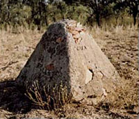
Here, Poeppel met up with Queensland surveyor, Alexander Salmond. Together they took star observations for latitude using both a transit theodolite and sextant to fix the position of that parallel. They marked the corner with a willow post 12 feet long, which was sunk over an iron bar.
The line was marked by mile posts mounded and trenched. A zinc plate was attached to the posts declaring the distance from the centre of the Murray River.
Poeppel then continued to mark the 26th parallel to the west. He reached the 138th meridian by the end of 1880 and returned to Adelaide in March 1881 due to the prevailing drought conditions. Many hardships were encountered on this survey as the line passed through vast stony, waterless plains, salt lakes and large sand hills. It was thought to be the most inhospitable country in Australia.
While Poeppel was recuperating in Adelaide, the South Australian triangulation survey had reached beyond the border. It was found that when checking the mile posts, they were in error because Poeppel's chain was 1 inch too long as a result of wear.
Queensland–Northern Territory border
The work of running the line true north along the 138th meridian from the intersection of the 26th parallel (Poeppel Corner) to the Gulf of Carpentaria, was carried out in early 1884 by Augustus Poeppel. He was assisted by Lawrence Wells, along with 6 assistants and 2 cameleers.

At the 250 mile post, the survey ceased for the 1884 Christmas break, allowing the survey party to have a well earned rest. Up until then drought conditions had prevailed.
In January 1885, rainy conditions delayed the surveying process. After conditions had improved, the survey recommenced with rapid progress until they reached the ranges north of the Nicholson River.
At the 324 mile post, Poeppel had to return to Adelaide due to severe eye problems. John Carruthers took his place as leader of the survey and Lawrence Wells continued as second in command. After rocky terrain, the country improved as the survey continued northwards and the pastoral stations became more frequent and closer to the boundary. Once they had reached the shores of the Gulf of Carpentaria in September 1886, they erected a large terminal survey post, 50 links above high-water mark.
It was later discovered that due to problems with Poeppel's theodolite, the line was surveyed at about 359°58'30" instead of true north (360°). This resulted in a discrepancy of about 600 metres into the Northern Territory at the shores of the Gulf of Carpentaria.
Checking the longitude
While Queensland did not provide a team for the Queensland–Northern Territory survey, they did check the position of the mile post on the border line west of Boulia.
Staff surveyor Cecil Twisden Bedford was chosen to carry out this check survey. Arriving in Boulia in August 1885, Bedford established his starting point in the post and telegraph reserve. This was the location where the longitude reading determined by electric telegraph was recorded. He traversed westward, connecting to the border with 77 chain posts to February 1886.
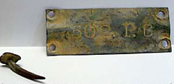
Bedford's traverse was marked with wooden mile posts for the 147 miles to the border. A bottle containing concrete and an empty brass cartridge case was sunk 2½ feet below every fifth wooden post.
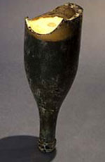
In 1988, as a special project for the Bicentennial year, the Queensland Division of the Institute of Engineering and Mining Surveyors of Australia retraced Bedford's survey and found his bottles.
Fixing the longitude
In 1887, Queensland staff surveyors, Robert Hoggan and Robert Grant McDowall, carried out observations at the post and telegraph station in Boulia. This fixed the longitude of Bedford's initial starting point. The method used was the exchange of time signals via the electric telegraph. This was between the Brisbane Observatory of known longitude, and Bedford's starting point beside the telegraph office in Boulia.