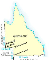
Queensland's borders since proclamation
On 6 June 1859, Queensland was proclaimed as a separate colony from New South Wales establishing the first borders of the state. A subsequent change was introduced in 1862 with a view to including a potential port on our north western shore, giving the state the borders that exist today.
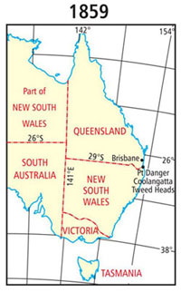
1859 Queensland – New South Wales border proclaimed
On 6 June 1859, Queen Victoria signed the letters patent that allowed for the formation of a new colony from New South Wales and this colony was to be called Queensland.
‘...Now know you, that We have, in pursuance of the powers vested in Us by the said Bill and Act, and of all other powers and authorities in Us in that behalf vested separated from our Colony of New South Wales, and erected in to a separate Colony, so much of the said colony of New South Wales as lies northward of a line commencing on the sea coast at Point Danger, in latitude about 28º 8’ south, and following the range thence which divides the waters of the Tweed, Richmond, and Clarence Rivers from those of the Logan and Brisbane Rivers, westerly, to the great dividing range between the waters falling to the east coast and those of the River Murray; following the great dividing range southerly to the range dividing the waters of Tenterfield Creek from those of the main head of the Dumaresq River; following that range westerly to the Dumaresq River; and following that river (which is locally known as the Severn) downward to its confluence with the Macintyre River; thence following the Macintyre River, which lower down becomes the Barwan, downward to the 29th parallel of south latitude, and following that parallel westerly to the 141st meridian of east longitude, which is the eastern boundary of South Australia, together with all and every the adjacent Islands, their members and appurtenances, in the Pacific Ocean: And do by these presents separate from our said colony of New South Wales and erect the said territory so described into a separate colony to be called the colony of Queensland...’ (Letters Patent 1859. Queensland Government Gazette, 1859, p. 1.)
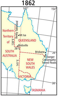
1862 change to Queensland's western border
The western boundary of the colony of Queensland was not clearly described in the Letters Patent of 1859:
‘...downward to the 29th parallel of south latitude and following that parallel westerly to the 141st meridian of east longitude which is the easterly boundary of South Australia...’ (Letters Patent 1859. Queensland Government Gazette, 1859, p. 1.)
Legal opinion given at the time stated that the 141st meridian was the western boundary of the colony.
In a memorandum to the Governor of Queensland dated 28 September 1860, the Surveyor General of Queensland, AC Gregory, described his views on the division of Northern Australia. This was with reference to the adjustment of the political boundaries. On Queensland's western boundary, he said:
‘The western boundary of Queensland, as at present defined, appears to be the 141st meridian, but it is probable that it was not described in the Letters Patent erecting the Colony, with greater distinctness, expressly with a view to a future adjustment, when more certain information should have been collected as to the natural features of the country.’
He went on to say:
‘It is now submitted that the 141st meridian passes through the tract of country known as the “Plains of Promise”, and that the eastern shore possesses no harbours. It would therefore be desirable to adopt the 138th meridian as the boundary; as that line would pass through a barren tract of country, and bring “Investigator Road” [harbour] within the limits of Queensland.’ (AC Gregory, 'Respecting the Western Boundary of Queensland', Queensland Parliamentary Papers, 1861, p. 3.)
In 1861, the South Australian, Victorian and Queensland governments funded expeditions to rescue Robert O'Hara Burke and his party. They had failed to return from their journey to the Gulf of Carpentaria in 1860.
The Queensland Government realised that these expeditions would increase the knowledge of the country in the vicinity of the Gulf.
On 5 September 1861, Queensland Governor Bowen informed the Secretary of State for the Colonies that Queensland legislature would protect any settlers who moved into the area. This was on the provision that the western boundary of Queensland was extended to include the Gulf of Carpentaria.
This proposal was accepted by the English Government, provided that the Queensland Government understood that the additional territory west of the 138th meridian could be taken back at a later date. This was with a view for the formation of another separate colony in that area.
On 12 April 1862, a supplementary commission altering the boundary of Queensland was issued by the English Government. These Letters Patent described the additional territory annexed to the Colony of Queensland as:
‘So much of our Colony of New South Wales as there to the northward of the twenty-sixth parallel of south latitude and between the one hundred and forty first and one hundred and thirty-eighth meridians of east longitude, together with all and every, the adjacent islands, their members and appurtenances in the Gulf of Carpentaria.’ (Letters Patent 1862. Queensland Government Gazette, 1859, p. 295.)
It was at this stage that the bend in the western boundary of Queensland came into existence.