Surveying the Queensland Northern Territory border
The work of running the line true north along the 138th meridian from the intersection of the 26th parallel (Poeppel Corner) to the Gulf of Carpentaria, was carried out in early 1884 by Augustus Poeppel. He was assisted by Lawrence Wells, along with 6 assistants and 2 cameleers.

At the 250 mile post, the survey ceased for the 1884 Christmas break, allowing the survey party to have a well earned rest. Up until then drought conditions had prevailed.
In January 1885, the rains came and local stations recorded as much as 43 centimetres in a few days. After the rains, conditions had improved and the survey recommenced with rapid progress until they reached the ranges north of the Nicholson River. Here the team experienced all sorts of difficulties including rocky terrain, a fire that destroyed their camp and raids by Aboriginals.
At the 324 mile post, Poeppel had to return to Adelaide due to severe eye problems.
John Carruthers took his place as leader of the survey and Lawrence Wells continued as second in command. The country improved as the survey continued northwards and the pastoral stations became more frequent and closer to the boundary. Once they had reached the shores of the Gulf of Carpentaria in September 1886, they erected a large terminal survey post, 50 links above high water mark.
It was later discovered that due to problems with Poeppel's theodolite he and his team ran the line at about 359°58'30" instead of true north 360°. This resulted in a discrepancy of about 600 metres into the Northern Territory at the shores of the Gulf of Carpentaria.

Checking longitude 138 degrees
While Queensland did not provide a team for the survey, they did check the position of the mile post on the border line west of Boulia.
Staff surveyor Cecil Twisden Bedford was chosen by the Queensland Surveyor General, William Alcock Tully to carry out this check survey.
Arriving in Boulia in August 1885, Bedford established his starting point in the post and telegraph reserve. This was the location where the longitude reading determined by electric telegraph was recorded.
Bedford then traversed westward to the border, connecting on to the border between the 255 mile and 255 mile 77 chain posts in February 1886.
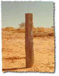
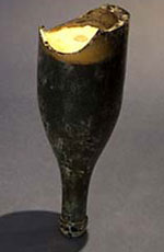
Bedford's traverse was marked with wooden mile posts for the 147 miles to the border. A bottle containing concrete and an empty brass cartridge case was sunk 2½ feet below every fifth wooden post.

Bedford's second in command, William Davidson, in later years wrote:
‘As white ants were very bad out there, it is quite possible that very few traces remain of our work above ground, but perhaps the bottles of cement we placed at every five miles along our line may prove interesting to scientists of some future generation, should they ever be unearthed.’ (WH Davidson 1885–6, 'Western Experiences', Queensland Geographical Journal, vol. 34-35, no. 20-21, p. 58.)
In 1988, as a special project for the Bicentennial year, the Queensland Division of the Institute of Engineering and Mining Surveyors of Australia retraced Bedford's survey and found his bottles.
Fixing the longitude
In 1887, Queensland staff surveyors Robert Hoggan and Robert Grant McDowall carried out observations at the post and telegraph station in Boulia. This fixed the longitude of Bedford's initial starting point.
The method used was the exchange of time signals via the electric telegraph. This was between the Brisbane Observatory of known longitude, and Bedford's starting point beside the telegraph office in Boulia. By using a traverse they were able to obtain a longitude value for the mile post out on the border west of Boulia. Bedford's observation revealed that the mile posts placed on the border by the South Australian surveyors were accurate.


