Laura
Introduction
The Laura community is located along the Laura River. The hilly, sandstone bluffs surrounding the town contain some of the largest galleries of Aboriginal rock art to be found in Australia. Many of the galleries feature depictions of Quinkans, spirits or supernatural beings who are traditionally believed to inhabit the sandstone bluffs. For this reason the Laura area is often referred to as Quinkan country. The ancient rock art sites provide historical evidence that Aboriginal people of the Laura region have lived in this area for many thousands of years prior to first contact with European explorers in the 19th century.
History of Laura
European contact
In 1872 the explorer and pastoralist William Hann led an expedition into the interior of Cape York. During the expedition, Hann visited the Laura area and members of his party opened fire on a group of Aboriginal men at the Laura River. Hann’s expedition discovered gold at the Palmer River on 5 August 1872[1]. The first gold prospectors led by James Mulligan arrived at the Palmer River in 1873[2]. A government surveyor, A C Macmillan, with a group of engineers protected by a detachment of Native Police, blazed a track from Cooktown to the Palmer River goldfields in October 1873. MacMillan named the Laura River after his wife Laura Bower[3].
Thousands of miners and prospectors soon flooded into the area. The town of Laura was founded as a staging camp on the road from Cooktown to the Palmer River goldfields, taking its name from the nearby river[4]. Pastoral stations were established in the Laura area in 1874. Harry Jones was the manager of stations at Boralga on the Laura River and also at Koolburrra. Donald Mackenzie established a station at Lakefield to the north of Laura[5].
Aboriginal people resisted the invasion of their lands by the miners and pastoralists. Frontier violence in the Laura region was a frequent occurrence during the 1870s, resulting in hundreds of casualties. By 1876, a Native Police camp was established at the Boralga junction of the Laura and Deighton Rivers[6]. In 1880 an entire detachment of Native Police troopers based at the Upper Laura barracks deserted, with 1 trooper attempting to kill their commanding officer Sub Inspector Stafford[7]. The Native Police maintained an active presence in the Laura region for more than 30 years. The Native Police camp at Laura was reclassified as a police station around 1910 but continued to employ a small group of Aboriginal police trackers[8].
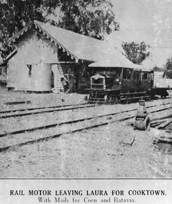
Work began on a railway from Cooktown to the Palmer River goldfields in 1885. The railway line reached Laura in 1888. During this period an overland telegraph line was also constructed from Laura running north to Somerset at the tip of Cape York. In the 1890s, mining activity in the Laura region slowly declined. Aboriginal men began to be employed as stockmen and workers on the pastoral stations and Aboriginal fringe camps were established on the outskirts of Laura[9]. An Aboriginal reserve on the Boggy Creek run at Butcher’s Hill, south east of Laura was gazetted by the Queensland Government in 1894. The reserve status of the land was rescinded in January 1908[10].
In 1897, the Queensland Government passed the Aboriginals Protection and Restriction of the Sale of Opium Act 1897. Under this Act and subsequent Aboriginal ‘protection’ Acts, local protectors were appointed to districts across Queensland including Laura. Protectors exercised control over Aboriginal labour and savings accounts and were authorised to remove Aboriginal people to reserves and missions across Queensland. There were 140 documented removals of Aboriginal people from the Laura area made between 1904 and 1959, including about 70 people from Laura to Palm Island and 29 people to Yarrabah[11].
In August 1967, 23 acres of land were officially gazetted as an Aboriginal reserve at Laura. The site had been used for many years as an Aboriginal camping ground and burial site[12].
The area around Laura is home to some of the most well-known and extensive Aboriginal rock art galleries in the world. During construction of the Peninsula Development Road in 1960, the Split Rock and Giant Horse rock art galleries were encountered by road construction crews. Percy Trezise, recognising the importance of the galleries, recorded them and actively campaigned for their protection. The sites were declared a protected area in 1972 and the Eastern and Western Quinkan Reserves were established in 1977. The Ang-Gnarra Aboriginal Corporation manages the rock art galleries today[13].
End notes
- Australian Dictionary of Biography, Hann, William (1837-1889) (2012) http://adb.anu.edu.au/biography/hann-william-3708 at 17 December 2012; P. Trezise, Last Days of a Wilderness (Collins, Sydney, 1973) 14, 16.
- Australian Dictionary of Biography, Mulligan, James venture (1837-1907) (2012) http://adb.anu.edu.au/biography/mulligan-james-venture-4269 at 17 December 2012.
- Queensland, Queensland place names online search (2012) https://www.dnrm.qld.gov.au/mapping-data/place-names/search/queensland-place-names-search at 17 December 2012;Trezise; above n 1 16-17.
- F Mackeith (ed.), Letters from Laura (James Cook University, Townsville, 1987), 1; Queensland, Queensland place names online search (2012) https://www.dnrm.qld.gov.au/mapping-data/place-names/search/queensland-place-names-search at 17 December 2012.
- G Pike, The Last Frontier (Pinevale Publications, Mareeba, 1983) 95.
- Author unknown, ‘The New Goldfields’, Brisbane Courier, 27 March 1876, 3.
- COL/A296, 80/3846; J. Richards, The Secret War: a history of Queensland’s Native Police (University of Queensland Press, St Lucia, 2008) 168-169.
- Richards; Above n 7,108.
- Mackeith; Above n 4, 10.
- Queensland, Queensland Government Gazette, 11 January 1908, 75.
- Smaller numbers were removed to Cape Bedford, Taroom, Barambah and Woorabinda. See Department of Aboriginal and Torres Strait Islander Partnerships, Community and Personal Histories Removals Database (access restricted).
- Queensland, Queensland Government Gazette, 26 August 1967, 1648.
- G Musgrave and T. George, The Quinkan Reserves (James Cook University, 2012) www.jcu.edu.au/rockart/quinkan_booklet at 17 December 2012; T George, Quinkan Rock Art: Images on Rock from the Laura Area (Ang-Gnarra Aboriginal Corporation, Laura, 1996); Above n 1, 203-206.