Kowanyama
Introduction
Kowanyama is located on the far west coast of Cape York, 600km northwest of Cairns. The community is positioned on the banks of Magnificent Creek, which joins the South Mitchell River.
Kowanyama means ‘place of many waters’ in the local Yir Yoront language. The Kokoberra, Yir Yoront (or Kokomnjen) and Kunjen clans are recognised as the Traditional Owners for this area[1]. Each group has its own distinct language and culture[2].
History of Kowanyama
European contact
The first European land explorers to visit the Kowanyama area came from the south. In his published journal for the years 1844 to 1845,[3] Dr Ludwig Leichhardt describes how he left Moreton Bay in 1845, on his way to Port Essington on Australia’s north coast. As the expedition approached Scrutton Creek, he describes how they were attacked by Aboriginal men who had been following their movements:
‘[A]s soon as it was dark, sneaked upon us, and threw a shower of spears at the tents … Charley and Brown … discharged their guns into the crowd of the natives, who instantly fled, leaving Roper and Calvert pierced with several spears, and severely beaten by their waddies. Not seeing Mr. Gilbert, I asked for him. He was lying on the ground at a little distance from our fire, and, upon examining him, I soon found, to my sorrow, that every sign of life had disappeared … Very early in the morning we heard the cooees of the natives, who seemed wailing, as if one of their number was either killed or severely wounded’[4].
In 1865, the settlement of Somerset was formed at the tip of Cape York after a recommendation from Governor Sir George Bowen that it would be a favourable location for a harbour of refuge and a well-positioned international trading port. Frank and Alexander Jardine formed a pastoral station at Cape York to supply the settlement[5].
The Jardine brothers had several skirmishes with Aboriginal people on their journey to Cape York that culminated in what the Jardine brothers named the ‘Battle of the Mitchell’[6]. On arriving at the Mitchell River:
(W)hilst the cattle halted … they came on to a number of blacks fishing, these immediately crossed to the other side, but on their return, swam across again in numbers, armed with large bundles of spears and some nullahs and met them ... The natives at first stood up courageously, but … they got huddled in a heap, in, and at the margin of the water, when ten carbines poured volley after volley into them from all directions, killing and wounding with every shot with very little return. About thirty being killed.[7]’
Gold mining brought further European settlement to Cape York after William Hann’s expedition found gold on the Palmer River in 1872[8]. In 1876, Robert Sefton found gold at Coen River and in 1878, there was a gold rush to Coen following Sefton’s return to Cooktown with 140 ounces of gold[9].
The town of Normanton was established by 1868 and a Native Police detachment was stationed there shortly afterwards[10]. The Overland Telegraph to Cape York was built between 1883 and 1887 and pastoral stations were established to supply the growing population of north Queensland. European settlement progressed further into Cape York with the help of Native Police protection after Native Police camps were established at Highbury in 1885 and Coen in 1888[11].
In 1896, Archibald Meston reported that the tribes from Albatross Bay down to the Mitchell River and the Gilbert River were still in ‘a perfectly wild state’[12]. He argued that the land was not needed for European settlement so there was no need to establish a mission in the area[13].
Closer settlement around Kowanyama began with the establishment of Rutland Plains Station in 1900[14]. Some Aboriginal people began to be employed on pastoral stations. Others continued to live as they always had. Moving through traditional lands became increasingly difficult as Aboriginal people were now ‘subject to the pleasure and approval of the pastoralists’[15].
In 1900, the Church of England created the Diocese of Carpentaria, which included Cape York Peninsula[16]. Gilbert White was appointed the first bishop of the diocese, based on Thursday Island. White was keen to establish a mission on Cape York Peninsula and gained support from the Northern Protector of Aboriginals, Walter Roth[17]. White requested and secured the help of Ernest Gribble to establish the mission[18].
Approximately 500 square miles was gazetted between the Mitchell and Nassau Rivers as an Aboriginal reserve[19]. The land was gazetted on 10 January 1903[20]. In 1905, Gribble, Bishop White and their staff established a permanent mission at Mitchell River[21].
The relationship between the Mitchell River Mission residents and the owners of the surrounding pastoral stations was strained, as the mission in some ways afforded its residents a form of protection against their abduction and kidnapping by pastoralists[22]. This relationship hit an all-time low when Frank Bowman of neighbouring Rutland Plains was fatally speared while trying to run several Aboriginal men off his property who were suspected of spearing cattle[23]. Bowman’s widow blamed the mission for her husband’s death because she thought that the mission harboured ‘undesirables’ such as those who had killed her husband. She mounted a vigorous campaign to have the mission removed further north[24].
The mission remained, but staff became more complicit with the pastoralists. The mission became a place where pastoralists came to recruit labour rather than a place to hide[25]. After Bowman’s death, pastoralists conducted a concerted campaign to remove from the district any Aboriginal people who they considered ‘troublesome’[26].
Between 1897 and 1972, there were 60 people removed from Mitchell River Mission. Most were removed to Palm Island and several others were removed to K’gari (formerly Fraser Island), Barambah and Lockhart River. Most of the mission residents came from the local area, but there were 59 removals to the mission from places such as Normanton, the Staaten River, Inkerman and the Gilbert River[27].
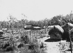
In 1917, the mission was moved because of saltwater seeping into local waterholes and creeks. The superintendent of the mission, Joseph Chapman, and two Aboriginal men, Peter Bendigo and Pindi, chose a new site for the mission 15 miles from the old mission on Magnificent Creek[28]. The name Kowanyama meaning ‘many waters’ was given to the new site, but for many years the mission was still referred to as the Mitchell River Mission[29].
By 1919, there were 160 people living on the mission and about 600 living in bush camps on the reserve. The population comprised members of the Kokoberra, Kunjen and Kokomnjen peoples.
Three outstations were also developed based on tribal affiliations and the mission segregation policy. The married Kokoberra lived at Daphne outstation, married Kunjen lived at Angeram outstation and married Kokomnjen lived at Koongalara[30]. In the early 1920s, the children were transferred from the main village to a small settlement of their own 2 miles away, where they received practical training in gardening[31].
In 1923, the mission superintendent, Joseph Chapman, began to visit the large semi-permanent Aboriginal camp at the mouth of the Edward River, which eventually became the Edward River Mission in 1939[32].
The introduction of a cattle herd was probably one of the most important innovations in the mission. The cattle industry at the Mitchell River Mission began in 1908. By 1923, the herd numbered 1,200 and by 1977 consisted of 16,759 beasts[33]. The mission became a valuable source of skilled stockmen and domestic servants, who went to work on the surrounding pastoral stations. The cattle industry at the Mitchell River Mission became so successful that it financed the whole of the Diocese of Carpentaria, but at the expense of the Mitchell River Mission and its people, who gained very little from its success[34].
By 1931, a school had been built and, in 1939, a new dormitory for girls was added[35]. In the 1950s, a boys’ dormitory was established. As of 31 March 1958, the mission had 40 boys and 59 girls attending the school[36]. The dormitories were officially closed on 1 May 1967[37].
Cyclone ‘Dora’ hit the mission on 3 February 1964 and caused extensive damage[38]. The Queensland Government put considerable funds into rebuilding the mission. The rebuilding program transformed the character of the mission. Previously there had been 3 villages of palm-leaf houses segregated by tribal affiliation. These were replaced by 1 village of metal-clad prefabricated houses. In 1966, the Anglican Church approached the government to take control of the mission. Responsibility for the mission was handed over to the Queensland Government on 1 May 1967. The mission became a government-administered reserve known as Kowanyama[39].
Local government and Deed of Grant in Trust community
On 30 March 1985, the Kowanyama community elected 5 councillors to constitute an autonomous Kowanyama Aboriginal Council established under the Community Services (Aborigines) Act 1984. The Act conferred Local Government-type powers and responsibilities upon Aboriginal councils for the first time.
On 23 July 1987, the council area (previously an Aboriginal reserve held by the Queensland Government) was transferred to the trusteeship of the council under a Deed of Grant in Trust (DOGIT).
On 1 January 2005, under the Local Government (Community Government Areas) Act 2004 (CGA), Kowanyama Aboriginal Council became the Kowanyama Aboriginal Shire Council.
End notes
- Kowanyama People v State of Queensland [2009] FCA 1192 (‘Kowanyama People’).
- Kowanyama Aboriginal Shire Council, Annual Report 2010-2011 (2011).
- L Leichhardt, Journal of Dr. Ludwig Leichhardt's overland expedition to Port Essington in the years 1844-45 (1846).
- Ibid.
- F Jardine and A Jardine, Narrative of the Overland Expedition of the Messrs. Jardine, from Rockhampton to Cape York, Northern Queensland (1867). Please note this book has been re-edited by Frederick J. Byerley (1949) and was last accessed 14 November 2012 at <http://www.gutenberg.org/files/4521/4521-h/4521-h.htm>.
- Ibid.
- Ibid.
- G Pike, Queen of the North: A Pictorial History of Cooktown and Cape York Peninsula (G Pike, Mareeba, 1979) 22-23.
- G Pike, The Last Frontier – Cape York Peninsula Wilderness (Pinevale Publications, 1983), 63-64; Author unknown, ‘The Coen’, The Queenslander, 13 July 1878.
- P Saenger, Sweers Island: Changes over two hundred years since Flinders’ visit (Southern Cross University, Lismore, 2005) 15.
- J Richards, The Secret War: A True History of Queensland’s Native Police (University of Queensland Press, St Lucia, 2008).
- Queensland, A. Meston, Report on the Aboriginals of Queensland (1896).
- Author unknown, ‘Aboriginals of Queensland’, Brisbane Courier, 21 October 1896, 6-7.
- LAN/AF160 (Lands Department, Pastoral Run File for Rutland Plains Station).
- P Freier, Living With the Munpitch: The History of the Mitchell River Mission, 1905-1967 (Unpublished PhD thesis, James Cook University, Townsville, 1999) 92.
- Anglican Diocese of Brisbane, Records of Diocese of Carpentaria (2006) <http://www.anglicanarchives.org.au/HDMS-HTML/Carpentaria/about.htm> at 14 November 2012.
- N Loos, White Christ, Black Cross: the emergence of a black church (Aboriginal Studies Press, 2007). 64; Queensland, Annual Report of the Northern Protector of Aboriginals for 1903 (1904).
- Loos, above n 17, 64-65.
- Loos, above n 17, 64.
- Freier, above n 15, 126.
- Ibid, 146-149.
- Ibid, 145-191.
- Ibid, 170-171.
- Ibid, 170-173.
- Ibid, 174-175.
- Ibid, 173-183.
- Department of Aboriginal and Torres Strait Islander Partnerships, Community and Personal Histories removals database (access restricted).
- Papers relating to the Mitchell River Mission (QSA Item ID: R 254, Box 318).
- Ibid.
- Freier, above n 16, 180, 183.
- Ibid, 185-186.
- Ibid, 185-194, 202.
- Ibid, 198-199.
- Ibid, 195-199.
- 1E/73 (Statement by the Bishop of Carpentaria, 29/6/1961); 1D/133: (Report on visit to Aboriginal Mission Stations, Gulf of Carpentaria, 12/4/1950 – 1/5/1950’, 9/5/1950, page 3); Loos, above n 17, 71-72.
- Queensland, Native Affairs, Information contained in Report of Director of Native Affairs for the Twelve Months ended 30th June 1958 (1958) 9.
- Admin, Child endowment, Mitchell River, 11 May 1967 (QSA Item ID SRS 505 Box 422, File 1H/118).
- Freier, above n 16.
- Ibid, 381-383.