Gondwana—Post-fire ecological assessment
A more detailed assessment of the ecological impacts of the fires was undertaken for each national park in this project. This was initiated with detailed fire severity mapping for the fire-impacted Lamington, Mt Barney and Main Range National Parks.
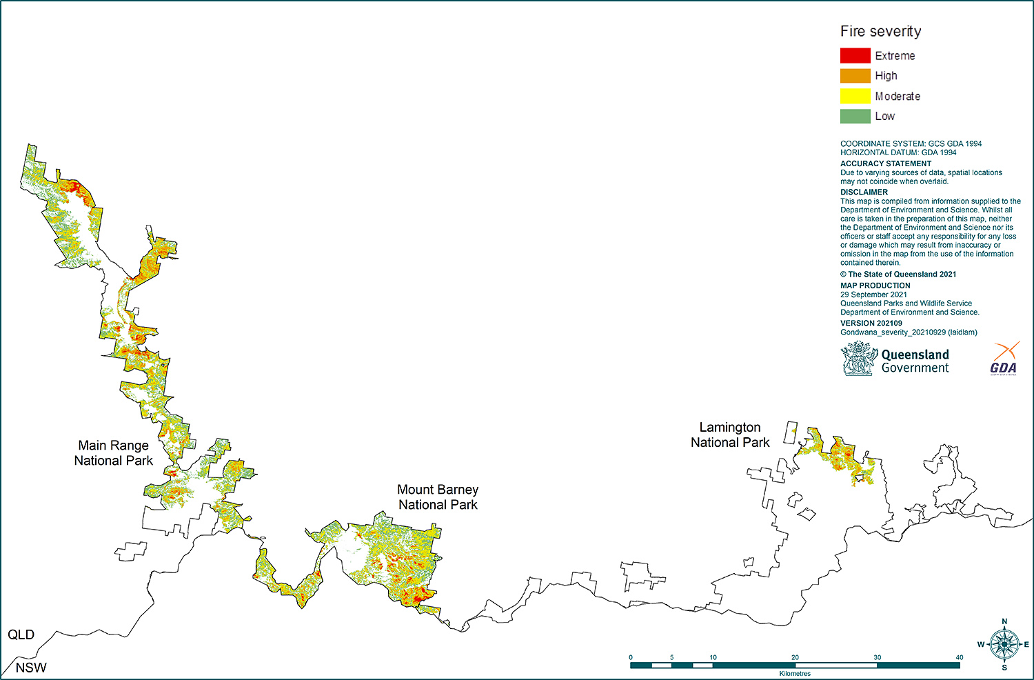
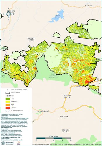
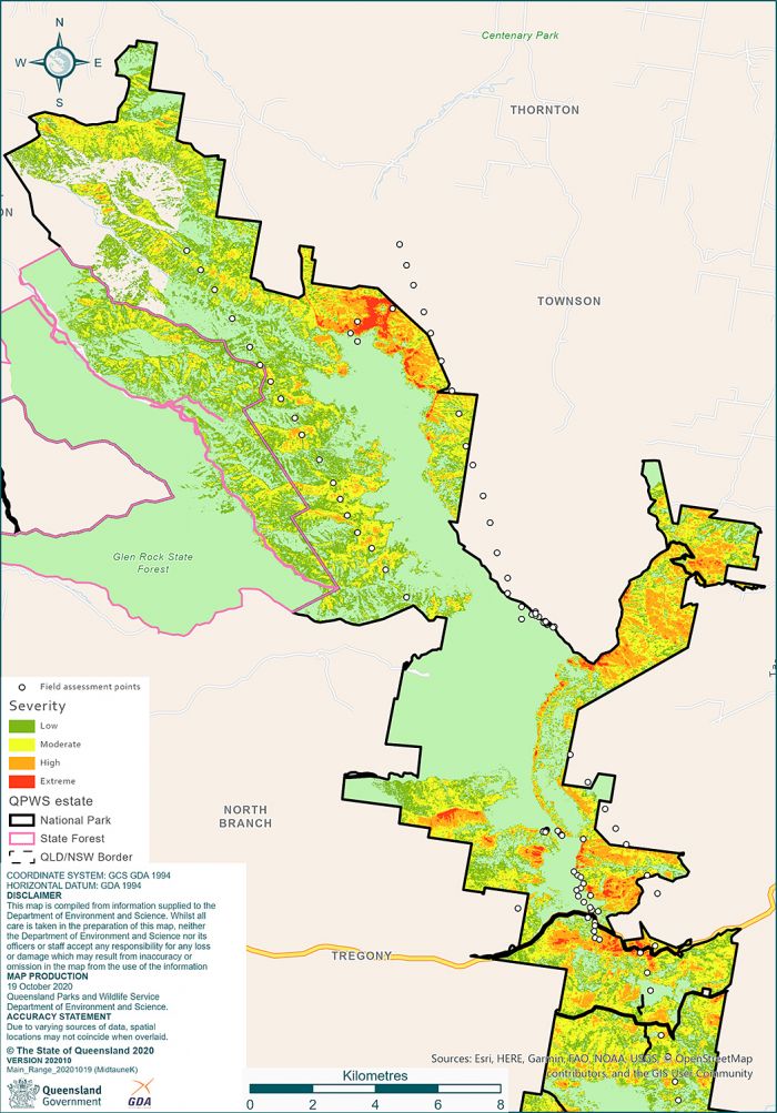
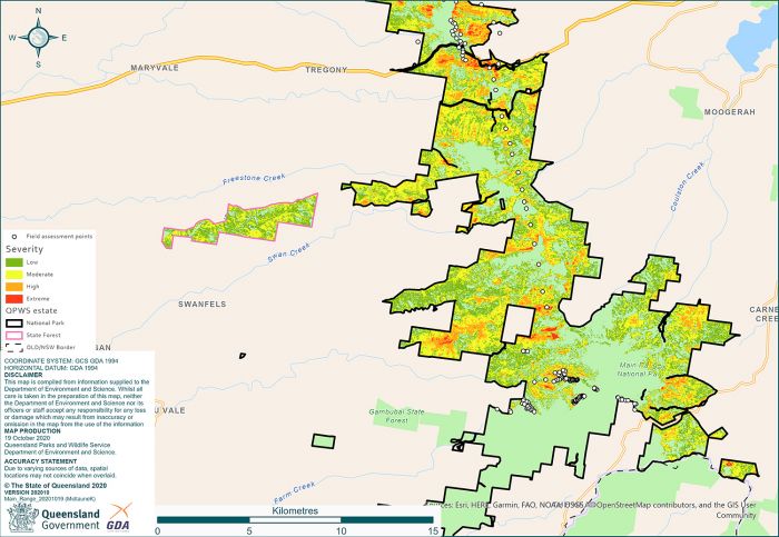
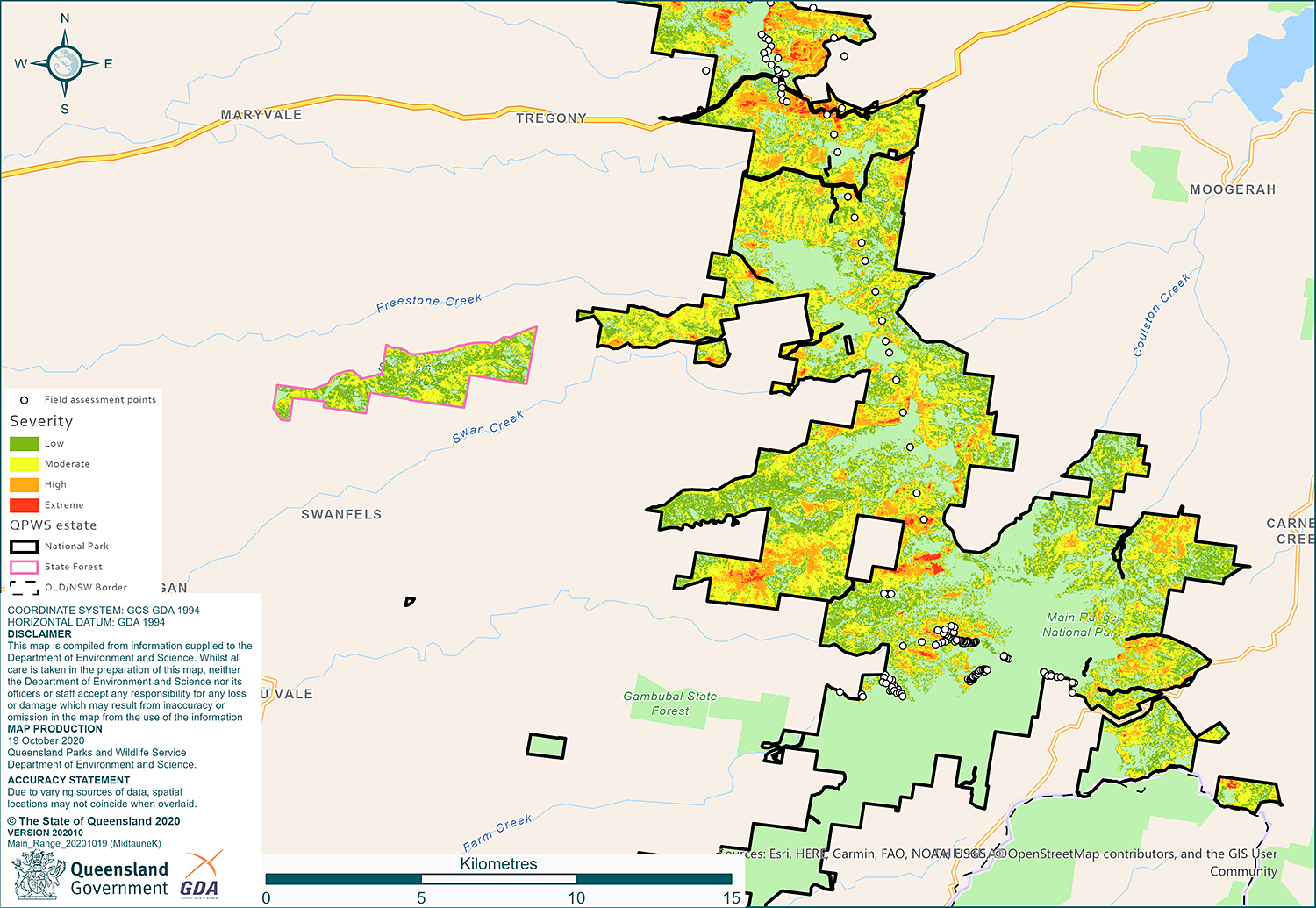
The overall extent and patterns of fire severity across the Gondwana World Heritage Area in Queensland are shown in the map below. Mt Barney and Main Range National Parks experienced very significant impacts in terms of fire extent and severity. In Lamington National Park the fires impacted a much smaller area, in the northern section of the park.

On this page
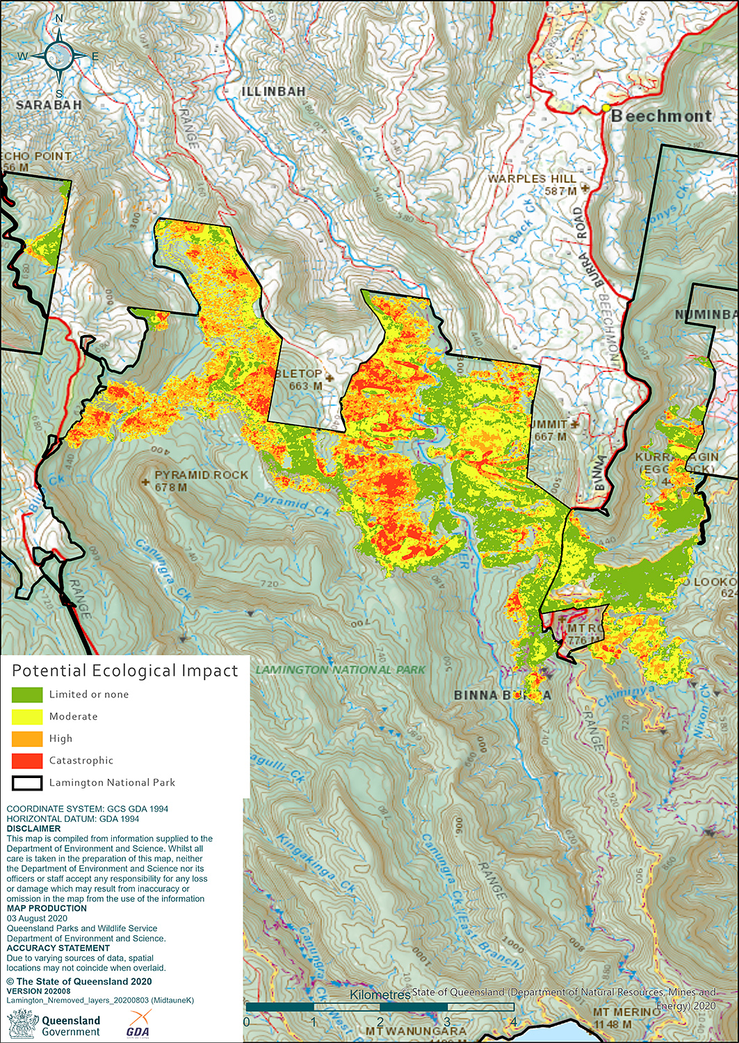
Lamington National Park
Overall, 1,532 hectares of land was burnt in Lamington National Park, mostly in the north-eastern corner of the park.
Read the full Post-fire assessment report for Lamington National Park (PDF, 1.7MB).
Fire severity
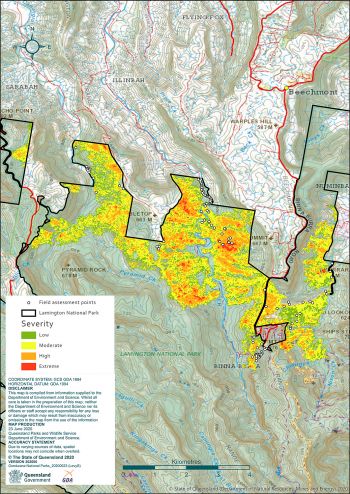
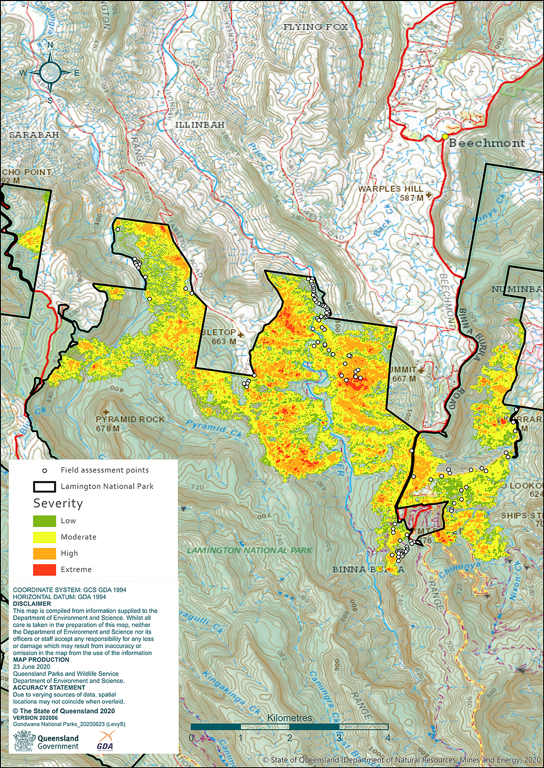
Half of the area burnt was at a moderate level of fire severity, where fire partially reached into the canopy. A quarter of the area burnt was at a high level of fire severity and almost another quarter of the area burnt was at a low level of severity. Two percent of the area burnt was at an extreme level which resulted in everything being completely consumed by the fire, including the canopy.
| Fire severity | Hectares |
|---|---|
| Low | 358 |
| Moderate | 765 |
| High | 378 |
| Extreme | 31 |
Ecological impacts
The ecological impacts of fire depend on the level of fire severity and the sensitivity of different types of plant communities to fire.
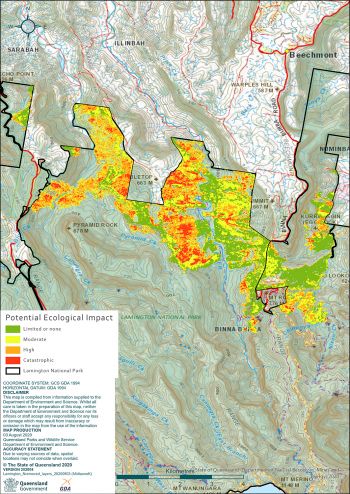
Dry eucalypt communities and woodlands are fire tolerant with both the canopy and the understorey adapted to fire and therefore capable of a relatively quick recovery, provided fires are not too severe or frequent.
At Lamington National Park, 663 hectares of this type of habitat burnt, with one-third having predicted ecological impacts at a moderate to high level.
Riparian corridors, wet eucalypt open forests and ecotones between these forests and rainforest typically have a fire tolerant canopy with a fire sensitive understorey that will be slower to recover after fire.
More than 200 hectares of this habitat type burnt with just over half having a potential ecological impact at a moderate level and just under a quarter experiencing a high to catastrophic level of potential impact, with a slow recovery process dependant on exclusion of future fires.
Plant communities in Lamington National Park that have both fire sensitive canopy and understorey are mostly lowland sub-tropical rainforest and dry vine forests.
More than 650 hectares of these communities burnt, with half burnt at a high potential ecological impact level and one-fifth at a catastrophic level.
The capacity of these plant communities to recover, will rely on a very slow process of regeneration, the right climate, the removal of invasive weeds and pest animals and no future fire events.
| Potential ecological impact class | Fire sensitive canopy and understorey | Fire tolerant canopy/fire sensitive understorey | Fire tolerant canopy and understorey |
|---|---|---|---|
| Limited or none | 0 | 50 | 432 |
| Moderate | 202 | 113 | 212 |
| High | 326 | 46 | 19 |
| Catastrophic | 130 | 2 | 0 |
Mt Barney National Park
Overall, 8,729 hectares of land was burnt across an extensive area of Mt Barney National Park.
Read the full Post-fire assessment report for Mt Barney National Park (PDF, 1.7MB).
Fire severity

At Mt Barney National Park, almost half of the area burnt was at a moderate level of fire severity, where the fire partially reached into the canopy. An additional 42% was burnt at low level of fire severity with the understorey, and not the canopy, mostly impacted. The rest, approximately 340 hectares, was burnt at a high to extreme level of fire severity, where flames scorched or consumed vegetation, including the canopy.
| Fire severity | Hectares |
|---|---|
| Low | 3645 |
| Moderate | 4016 |
| High | 801 |
| Extreme | 267 |
Ecological impact
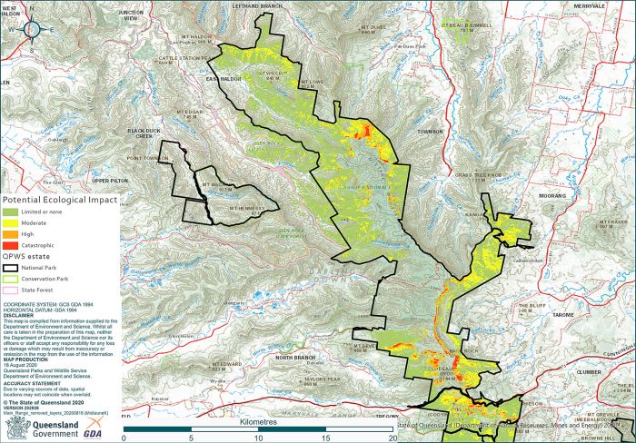
Considering the type of vegetation burnt, and its sensitivity to fire, the map of predicted ecological impacts highlights the areas of greatest ecological concern across Mt Barney National Park.
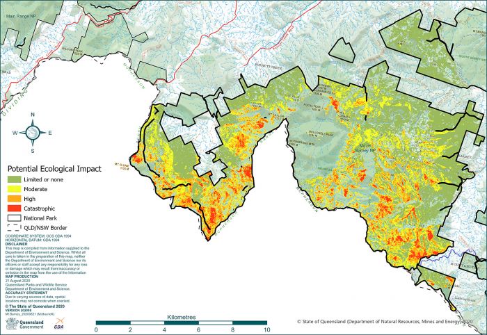
Almost half of the area burnt was vegetation that has a fire tolerant canopy and understorey. However, given the fire severity, approximately 10% is predicted to have a moderate to high level of ecological impact. This includes montane heath and shrublands, as well as eucalypt open forests and woodlands that will need to be protected from subsequent fires until natural regeneration has occurred.
Those plant communities with a fire tolerant canopy but a fire sensitive understorey represented nearly 30% of the burnt area. Almost two-thirds of this burnt habitat type had a moderate to catastrophic level of potential ecological impact. Riparian corridors and wet eucalypt forest and ecotones fall into this category.
The most fire sensitive communities, those with both the canopy and understorey not adapted to fire, also burnt at Mt Barney, representing a quarter of the fire-scarred landscape. For this habitat, the fire severity levels were such that 60% of the burnt habitat (more than 1,300 hectares) had a high to catastrophic level of potential ecological impact. This includes a wide range of microphyll, notophyll and mesophyll vine forests, some with hoop pine emergents, which may struggle to recover.
| Potential ecological impact class | Fire sensitive canopy and understorey | Fire tolerant canopy/fire sensitive understorey | Fire tolerant canopy and understorey |
|---|---|---|---|
| Limited or none | 0 | 918 | 3643 |
| Moderate | 855 | 1247 | 273 |
| High | 998 | 264 | 97 |
| Catastrophic | 341 | 94 | 0 |
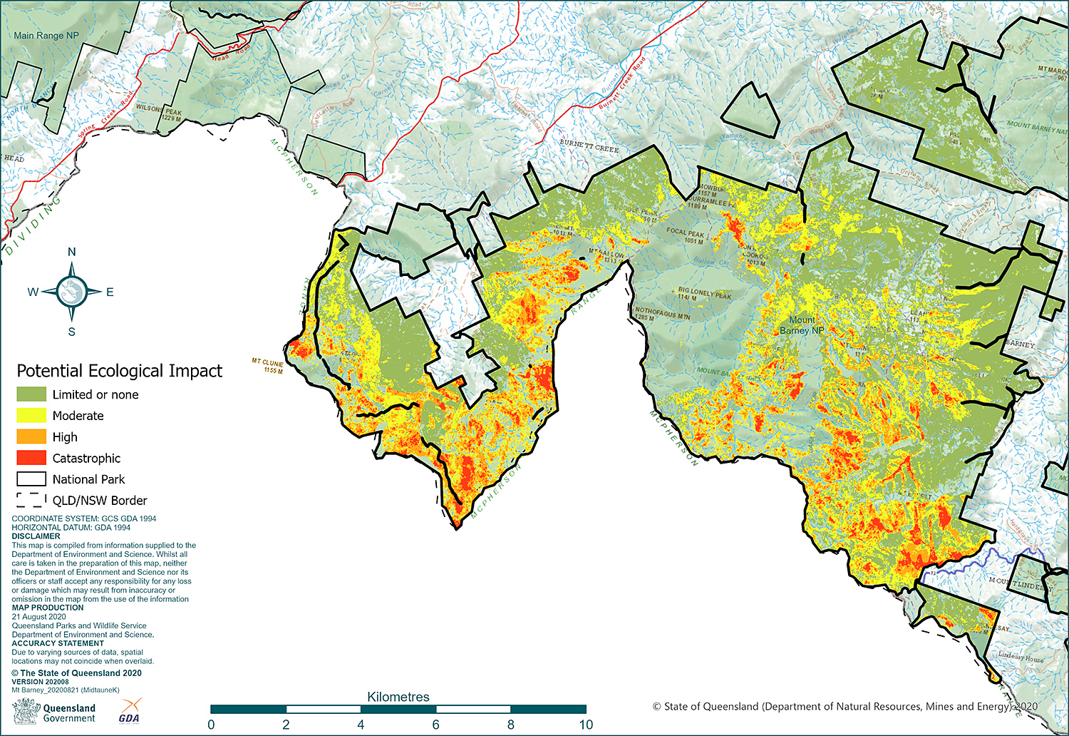
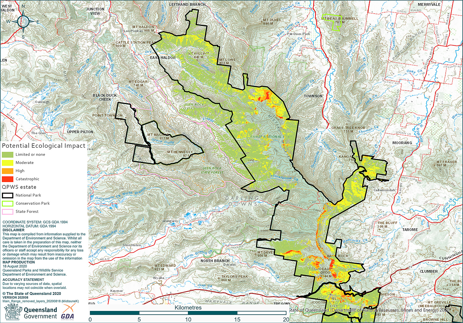
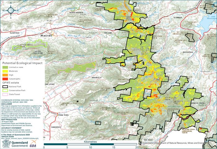
Main Range National Park
Overall, 19,592 hectares of land burnt across the Main Range National Park and adjoining protected areas, of which 11,723 hectares were within the Gondwana World Heritage Area.
Read the full Post-fire assessment report for Main Range (PDF, 1.7MB).
Fire severity
Approximately 40% of the area burnt at both a moderate and low level of fire severity. The remaining 17% was burnt at a high to extreme level of fire severity. This resulted in the understorey being destroyed and the vegetation canopy being partially or fully consumed by the fire.

| Fire severity | Hectares |
|---|---|
| Low | 8447 |
| Moderate | 7490 |
| High | 2910 |
| Extreme | 346 |
Ecological impact
Across Main Range National Park, moderate to high potential ecological impacts were spread across numerous areas.

| Potential ecological impact class | Fire sensitive canopy and understorey | Fire tolerant canopy/fire sensitive understorey | Fire tolerant canopy and understorey |
|---|---|---|---|
| Limited or none | 0 | 1742 | 11178 |
| Moderate | 842 | 1624 | 2029 |
| High | 551 | 632 | 218 |
| Catastrophic | 302 | 75 | 0 |
More than 13,400 hectares of vegetation with both a fire tolerant canopy and understorey was burnt. This included dry eucalypt forests and woodlands and montane heath and shrublands. More than 80% had limited potential ecological impacts, with possible short-term effects on fauna and a relatively quick regeneration of native plants (assuming there are no subsequent fires during the recovery phase). The other 17% had moderate to high levels of potential ecological impact. These impacts can include a longer period of absent food resources for fauna and a permanent loss of important habitat features such as large hollow bearing trees that can take decades to hundreds of years to replace.
Vegetation with a fire tolerant canopy but a fire sensitive understorey (such as wet eucalypt forests, rainforest/eucalypt forest ecotones or some riparian corridors) had more than 4,000 hectares burnt. Just over 40% of this habitat type was burnt at low fire severity with limited, short-term potential ecological impacts on the understorey. Another 40% had moderate potential ecological impacts with possible localised decline of some understorey species with poor regenerative capacity. The remaining areas had moderate to catastrophic level potential impacts where flora and fauna species may be permanently lost.
Almost 13% of the area that burnt (nearly 1,700ha) were plant communities with both fire-sensitive canopy and understorey. Half of this area, represented by rainforests or palm-dominated riparian corridors, had potential ecological impacts at a moderate level with the other half at a high to catastrophic level. Damage to, or loss of, a plant canopy removes the critical moist microclimate that sustains the presence and germination of the typical plant species of these habitats. Large canopy trees, such as figs, can be directly killed by the fire or succumb over time due to disease or a lack of moisture. The fleshy seeds characteristic of rainforests are readily destroyed by heat or flames and regeneration may require animal dispersal of seeds from other unburnt sites. The fire-induced changes present a significant risk to recovery for these ecosystems.