Ground cover explained
What is ground cover?
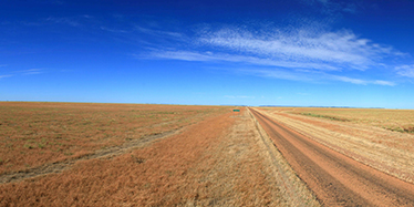
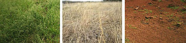
Ground cover is the vegetation (living and dead) and biological crusts that are in contact with the soil surface. Ground cover includes both green (i.e. photosynthetic vegetation) and non-green (i.e. non-photosynthetic dry vegetation and plant litter) areas.
The level of ground cover is the result of interactions between landscape attributes (soil type, topography and vegetation dynamics), climate, and land management. Some areas support naturally higher levels of ground cover due to factors such as high soil fertility and consistently high annual rainfall.
The amount and type of ground cover affects many soil processes including infiltration, runoff and surface erosion. Maintenance of ground cover is essential for sustainable production, especially in rangeland environments where rainfall is highly variable.
Remote sensing scientists use satellite imagery, captured on a regular basis, to measure and monitor ground cover across Queensland. By analysing the imagery, the scientists can investigate how areas of ground cover and bare soil surface change through time and space.
How is ground cover data used?

Ground cover information is used by landholders, natural resource managers and government to improve land management. For example, fire intensity is related to fuel load, which is in turn related to the amount and type of ground cover.
Areas of persistently low or high cover may be identified through analysis of the ground cover data. Land managers can then consider if they need to respond. For example, an area of persistently low cover may require a lower stocking rate. Monitoring changes in ground cover thus plays an important role in:
- protecting valuable soil resources from wind and water erosion
- planning activities like stocking rates and fire management
- maintaining biodiversity by mapping changes in habitat resources
- understanding nutrient cycling.
Contact us
For more information about accessing ground cover products, contact our Principal Scientist via email at deanna.vandenberg@des.qld.gov.au.