Glossary
On this page
Astronomical tide
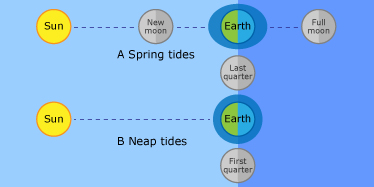
Refers to the periodic rise and fall of water along the coast due to gravitational interactions between the moon, sun and the earth.
When the moon, sun and earth are in line, their combined attraction is stronger and the tide range is greater (spring tides).
When the moon and sun are at right angles to each other (in relation to the earth), the effect of the attraction is somewhat reduced and the tide range is smaller (neap tides).
Australian Eastern Standard Time (AEST)
The standard time for Queensland, Australia, as defined by the Standard Time Act 1894.
AEST is based on the meridian 150 degrees east and is 10 hours earlier than universal time, which is expressed in relation to the 0 degree meridian at Greenwich, England.
Australian height datum (AHD)
The datum (adopted by the National Mapping Council of Australia) to which all vertical control for mapping is to be referred to.
Chart datum
The level of water to which all depths and drying heights on a chart are related.
It is a level so low that the tide will not frequently fall below it.
For Australian waters, chart datum is defined as the lowest astronomical tide.
Highest astronomical tide (HAT)
The highest level of water that can be predicted to occur under average meteorological conditions and any combination of astronomical conditions. This level may not be reached every year.
When a storm tide level is higher than the highest astronomical tide it is more likely to cause inundation and flooding in coastal areas.
King tides
The term king tide has no scientific definition. In popular use, it refers to the highest tide (see astronomical tide) that occurs at a location per year.
King tides generally occur in summer. However, they sometimes also occur in winter.
The highest winter tides occur at night and are not as apparent as those during summer, which generally occur during the daylight hours.
During normal weather conditions, the height of the king tides will be similar from year to year. In abnormal weather conditions (severe storms or tropical cyclones), the low air pressures and strong winds can elevate the sea level above the expected height.
Read more about king tides at the Maritime Safety Queensland website.
Lowest astronomical tide (LAT)
The lowest tide level that can be predicted to occur under average meteorological conditions and any combination of astronomical conditions. This level may not be reached every year.
Mean sea level (MSL)
The value obtained at a site by averaging hourly tide heights observed over a long period of time (preferably 18.6 years). It is also the average water level that would exist in the absence of tides.
Predicted tide
Tide expected to occur under average meteorological conditions.
Tide predictions are typically based on actual tide readings gathered over 1 year or more.
The sun, moon and earth are not in the same relative position from year to year. Accordingly, the gravitational forces that generate the tides, and the tides themselves, are not the same each year.
The official tide predictions for Queensland ports are supplied by the Bureau of Meteorology, National Tidal Centre.
For some ports where a storm tide gauge is the only tide gauge, the storm tide data is used as the basis of the official tide predictions.
Residual
The difference between the predicted tide—under average weather conditions—and the actual tide height.
Actual tides include the height of the tide itself, and the height variations (residuals) that result from the effects of the weather on the height of the sea level.
The residuals give a measure of height of storm surges during severe (cyclonic) weather conditions.
The components of the residuals are (see illustration under storm tide):
Seiche
A standing oscillation in an enclosed or semi-enclosed body of water that continues after the end of the original force.
They can be triggered in an otherwise still body of water by strong winds, changes in atmospheric pressure, earthquakes, tsunami or tides.
The waves in a seiche are stationary in the horizontal plane and do not progress forward. The waves move up and down, but not forward like wind waves at sea.
Storm surge
An increase in water level associated with some significant meteorological event such as:
- persistent strong winds
- falling barometric pressure
- tropical cyclone.
A storm surge is an abnormal rise of water level generated by a storm over and above the predicted tide level.
Storm surges are the combined effect of wind set-up and wave set-up, and falling barometric pressure. In some situations, when winds blow offshore, sea level can fall lower than the predicted tide level too.
The magnitude of the storm surge depends on the severity and duration of the event and the seabed topography at the site. In Queensland, most large surges are caused by tropical cyclones.
Storm tide
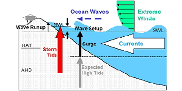
The combination of a storm surge and the normal astronomical tide.
If the storm surge arrives at the same time as the high tide, the potential risk of inundation, flooding and erosion is greater than at a lower tide. An additional threat at this time could come from the presence of very high waves (wave run-up).
The inundation produced by a storm tide is often exacerbated by wave run-up, waves overtopping natural or constructed levees and localised intense rainfall. This can lead to coincident flooding if combined with the effects of riverine (freshwater) flooding.
Storm tide gauge

A specially designed structure, built to withstand severe weather and storm surge, housing instruments that digitally record sea level at regular intervals.
The basic components of the typical storm tide gauge include a:
- stilling-well tube (steel 600mm diameter or PVC 150mm diameter) with straightening plates and an opening that serves to dampen the effects of waves, and to eliminate any effects of debris in the water.
- free-to-air sensor—a radar unit mounted above the highest expected storm surge height. It uses high frequency microwave pulses that reflect off the water surface to measure the water level.
- stilling-well sensor—a microwave wire sensor mounted inside the stilling well. The microwave- wire sensor measures the water level by sending high frequency pulses along the wire. These pulses reflect off the water surface. Similarly to the free-to-air sensor, a water level is obtained by measuring the time taken for the impulse to travel from the sensor to the water surface and reflect back to the sensor.
- data logger—the sensors are connected to the data logger which logs the water level referenced to lowest astronomical tide. This level is stored every minute along with the time of the recording.
- modem—the data logger is connected to the internet so that storm tide data can be transferred to our central computer system (data server) in Brisbane for checking, processing and archiving. We then publish the storm tide data online—see our storm tide monitoring sites to view the data plots.
All instruments are battery-powered, with mains-powered charger recharging the battery during normal operation as a safeguard to ensure the system will keep up during severe weather.
Tropical cyclone
A non-frontal low pressure system (below 1000hPa) rotating clockwise (in the southern hemisphere) that is of tropical origin and in which 10-minute mean wind speeds exceed gale force (63km/hr, 34kt or 17.5m/s).
Tsunami
A wave generated by seismic activity. It is also called a seismic sea wave, or incorrectly a tidal wave.
Barely visible in the open ocean, the amplitude of a tsunami may increase greatly as it approaches shallow coastal waters.
Tsunami waves travel in groups (wave trains) and often the largest wave occurs long after the arrival of the first wave. This is particularly evident within harbours and bays where seiching can increase the height of the tsunami wave.
Storm tide gauges along the Queensland coast have detected tsunami signals from seismic events in Central and South America, from Japan and Indonesia.
Read more about tsunamis and tsunami warnings at the Bureau of Meteorology website.
Wave run-up
This is the rush of water up a beach after a wave reaches the shoreline.
The amount of wave run-up is the vertical distance between the maximum height the rush of water reaches on the beach and the still water level.
Wave run-up depends on many factors including wave height, wave period, and the slope and composition of the beach.
Wave set-up
Refers to an increase in the mean water level towards the shoreline, caused by wave action. This can be important during storm events as it results in an increase in water level above the tide.
Wind set-up
The vertical rise of a body of water above still water level, caused by wind stresses on the surface of the water.
Wind setup at the coast can force the sea level higher or lower than the predicted tide depending on the direction of the wind relative to the coast.
When the wind is blowing towards the coast (onshore), water will be piled up against the coast and raise the sea level.
When the wind is blowing offshore, water is pushed away from the coast and sea levels fall.