About wave monitoring
We maintain a network of wave monitoring sites to measure the height and direction of waves along the Queensland coast.
Collecting wave data helps us understand how waves behave in calm and stormy weather conditions. This can be used to protect lives and property.
For example, when a cyclone is approaching the coast, we provide data to the Bureau of Meteorology and to Emergency Management Queensland to evaluate the potential impacts of waves on coastal communities.
Find out more:
- Who uses wave data?
- How are waves monitored?
- Wave monitoring buoy calibration checks
- Online wave data
- Publications
Who uses wave data?
Queensland’s wave information is used by:
- planners and engineers in the design and construction of coastal structures and the investigation of natural coastal processes, including accretion and erosion
- emergency services during the cyclone season
- individuals, tourism and recreational businesses for planning of fishing or small craft activities
- maritime organisations to plan port activities and to support navigational safety
- large ocean-going vessels for calibration and verification of numerical wave models. These models cover large-scale areas and provide guidance and input to forecasts and warnings on the high seas for periods of up to 24 hours in advance.
- global wave modelling to improve the reliability of wave forecasting worldwide
- the Bureau of Meteorology as input to forecasts for specific coastal areas and up to 60 nautical miles seaward.
How are waves monitored?
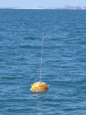
We use wave monitoring buoys to continuously measure wave height, wave direction and wave period.
As a wave monitoring buoy floats up and down each passing wave, its motion (or heave) is measured and electronically processed.
Data from the wave monitoring buoys are transmitted to a nearby receiver station as a radio signal.
Receiver station configuration
Our receiver stations are comprised of a radio receiver, a computer, a modem and power components. The radio receiver is linked to a computer that stores, analyses and summarises the wave data. The computer controls the timing of data recording, and processes the data in near-real time.
The recorded data and analysis results are automatically downloaded from each receiver station every hour to a central computer system (data server) in Brisbane for checking, further processing and archiving.
Each receiver station is maintained and updated by specialised technicians and can be remotely accessed via the internet.
Batteries are used to ensure that all equipment at each receiver station is backed up in case of power failure, which is likely to occur in critical events such as cyclones.
If the transmission between the wave monitoring buoy and the receiver station is interrupted for an extended period, the data can be recovered from the internal memory of the wave monitoring buoy once it has been retrieved from the ocean.
Online wave data
Wave monitoring data is downloaded from receiver stations every hour, and new wave plots are uploaded to the web after approximately 20 minutes.
Where available, plots show wave height, wave direction, wave period and sea surface temperature.
Check the wave monitoring data of the last 3.5 days.
Check the longer-term data at the coastal data system—waves section of the Queensland Government Open Data portal.
Publications
We report on the wave data collected at our wave monitoring sites in a range of publications.
To access these publications, go to the library catalogue and search for:
- Queensland wave climate annual summary—to view our annual reports since 2000
- wave data recording program—to view data summaries from selected wave monitoring sites.
Queensland Government Hydraulics Laboratory Waves Publications can also be found at: