Flood warning infrastructure
Queensland’s flood warning infrastructure network
In Queensland, more than 3200 rainfall and river gauges inform statewide flood warnings and forecasts. These are owned and operated by multiple entities including state and local government, the private sector, and the Bureau of Meteorology.
Flood waters don’t respect boundaries so it is extremely important for all areas of Queensland to work together and share information from other warning systems. This will help keep our communities safe by ensuring they are well informed by timely weather and flood warnings and forecasts. A high level of collaboration and information sharing is necessary to ensure accurate and consistent flood warning information is being provided to the Bureau of Meteorology and to our local communities.
Types of flood warning infrastructure
There are several different types of flood warning infrastructure used in Queensland including: automatic rain gauges, automatic rain and river gauges, manual rain gauges and manual river gauges. Learn about the different types of gauges.
| Gauge type and description | Image |
|---|---|
Automatic rain gaugesRain gauges are placed around catchments across Queensland to monitor the level of rainfall. These gauges can vary in their appearance and how they work. This one is an automatic rain gauge and can relay data to the Bureau of Meteorology on a real time basis using either 3G/4G or UHF technology. | 
|
Automatic rain and river gaugesAutomatic rain and river gauges use a range of sensors that relay data to the Bureau of Meteorology on a real time basis using either 3G/4G or UHF technology. Some automatic rain and river height may also have a traffic camera strategically located near a river crossing so water levels can be monitored for road safety. |  |
Manual river gaugesOur river gauges measure water levels along our river systems. This manual river gauge is read by volunteers who visit the gauge location and report to the Bureau of Meteorology on the height of that river on a daily, or sometimes as the river rises, hourly basis | 
|
Manual rain gaugesRain gauges are placed around the catchments all over Queensland to monitor the level of rainfall. These gauges can vary in their appearance and gauges. They can be automatic or manual. This is an example of a manual rain gauge. |  |
Alternative flood warning infrastructure - rain and level gaugesAlternative flood warning infrastructure rain and level gauges complement the existing Flood Warning Infrastructure Standard gauge network to provide near real-time rainfall and water level data to local and state government agencies as well as the Bureau of Meteorology around catchments across Queensland. Alternative flood warning infrastructure gauges use a range of sensor technologies to measure rainfall and water and are generally small, lightweight, waterproof units installed on posts, signage, bridges or other infrastructure. | 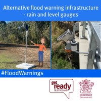 |
How flood warning infrastructure works: Rain and river gauges, cameras and signs
This 7 minute educational video covers the Queensland Flood Warning Infrastructure Network (FWIN) project for the Far North, North West and Townsville regions. It explains the differences between the four types of flood warning assets that have been installed for councils, including technology features and specifications, and how they work to provide the best possible flood warnings. Learn how these Rain gauges, Rain /River Towers, Flood Warning Cameras, and Flood Warnings Signs are helping to protect our Queensland communities.