The new zoning plan came into effect 21 May 2024
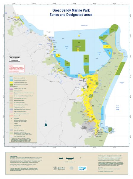
Located in Queensland’s Wide Bay-Burnett Region, the Queensland Parks and Wildlife Service (QPWS) manages the Great Sandy Marine Park. The management arrangements for this marine park are detailed in its zoning plan.
The zoning plan identifies different zones within the marine park, what kind of activities can be undertaken in each, and levels of protection to maintain environments and habitats.
The new zoning plan came into effect on 21 May following a comprehensive review aimed at increasing the long-term conservation of marine life and their habitats. Read more about the development of the new zoning plan for the Great Sandy Marine Park.

New zoning plan from 21 May 2024
How the new zoning works
The marine park’s management arrangements are detailed in a new zoning plan. Four zones ranging from no-take marine national park (green) zones to general use zones and eleven designated areas protect the marine park’s natural and cultural values, conserving migratory shorebirds, marine turtles and dugong.
How the new zoning plan was developed
The Queensland Government completed its review of the zoning plan for the Great Sandy Marine Park in July 2023.
New Marine Parks app
A new marine parks zoning app has been developed, so you can pinpoint your exact location and find out what zones and designated area rules apply to you.
What you can and can’t do in each zone
An overview of the different activities that can be carried out in the different marine park zones.
Changes affecting recreational fishing and boating
- zone extensions across the marine park
- new and expanded Go Slow Areas and strengthened rules
- three new No Anchoring Areas in Platypus Bay, Gatakers Bay and Gables Point (Point Vernon)
- new No Motorised Vessel Areas in Searys Creek and Cooloola Creek
- a new designated area in northeast Platypus Bay prohibiting motorised water sports
- changes to line/hookuse in yellow zones
Changes affecting commercial fishing
The new Great Sandy Marine Park Zoning prohibits large mesh gill nets and ring nets from the Conservation Park zones within large areas of the marine park and other zoning changes bringing changes for the commercial fishing sector.
Do the right thing
Penalties apply for non-compliance with zoning plan rules.
Rangers patrol the marine park and are on the lookout for inappropriate activities such as:
- travelling on the plane in ‘Go Slow’ areas
- fishing or collecting in ‘green zones’
- not abiding by whale watching approach distances.
Frequently asked questions
Learn more about the zoning plan, designated areas and rules.
Why did the zoning plan change?
Globally, marine biodiversity is under threat from a range of factors including climate change, population growth, pollution and increasing use. The Great Sandy Marine Park is being impacted by these global trends and the new zoning plan will help address threats to the long-term conservation of wildlife and their habitats and preserve and enhance the region’s lifestyle and economic strengths.
The Great Sandy Marine Park:
- boasts 23 broad habitat types, however several of these are under-represented in the highly protected zones under the existing zoning plan, placing the marine park’s biodiversity and critical species at risk
- has seen a significant decrease in its extent of seagrass habitat
- is seeing a significant increase in mature marine turtle and dugong strandings resulting from a range of causes including boat strike, poor health and flooding
- includes the only known gestation site on the east coast of Australia for the critically endangered grey nurse shark, however the existing zoning plan does not effectively protect sharks at this key aggregation site from being hooked or accidentally caught by recreational and commercial line fishers
- is seeing a decrease in the numbers of many migratory shorebird species, some by more than 10% per year
- is subject to increasing coastal impacts from severe weather events caused by climate change.
What are the opportunities and benefits?
The new zoning plan provides the opportunity to:
- better protect cultural values, respect and recognise First Nations peoples’ native title rights and responsibilities for caring for their sea Country
- improve biodiversity and provide better protection of several iconic and threatened species, which are significant nationally and internationally including whales, dolphins, dugongs, turtles, grey nurse sharks and shorebirds
- largely maintain the use of the marine park by the commercial trawl, crab, line and harvest fisheries, and those components of the net fishery that are of a lesser risk to threatened species
- enhance the region’s enviable nature-based and recreational fishing lifestyle
- support future economic growth in the region based on nature-based tourism, recreational and charter fishing and, where appropriate, aquaculture
- assist local councils to address coastal impacts of climate change
- is subject to a range of demands from competing uses.