Bamaga
Introduction
Bamaga is 1 of 5 communities that collectively form the Northern Peninsula Area (NPA) at the tip of Cape York. Injinoo, Umagico (Alau), New Mapoon and Seisia communities make up the remainder of the NPA.
There are several Native Title applications currently before the courts from the following groups in this region: Atambaya (Ut-tam-bye-a)[1], Gudang (Good-ung)[2], Yadhaykenu (Yad-ak-ken-u)[3], Ankamuthi (Ang-a-muty)[4], the Wuthathi (Wuth-th-thi)[5] and the Kaurareg People[6]. At the time of writing this history, however, there has been no determination of native title.
The Aboriginal language name for the Bamaga area is Ichuru.[7]
History of Bamaga
European contact
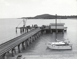
During World War Two, a military airstrip was constructed inland from Red Island Point by American army engineers. The airstrip, known as the Jacky Jacky or Higgins airstrip, is still used today as the airport for the NPA. New jetties and wharves were built by the engineers at Muttee Heads and Red Island Point.[8]
At the end of World War Two, the Queensland Government introduced measures to compensate Torres Strait Islanders for their contribution to the war effort, and to populate the north as a defence against foreign invasion.[9] In his address to the 1947 Island Councillors’ Conference, Director of Native Affairs Cornelius O’Leary, spoke of the government’s ‘wish for the expansion of the Torres Strait Race as a healthy industrial unit in North Queensland’.[10]
After the war, enlisted Torres Strait Islander men from Saibai, Dauan and Boigu also discussed the possibility of developing a community on the mainland. Saibai elder Bamaga Ginau supported the proposal. In 1947, king tides caused serious damage to properties and gardens across Saibai. Bamaga Ginau called a meeting regarding the future of Saibai and after much discussion a number of families made the decision to leave Saibai and move to the mainland.[11]
The first Torres Strait Islander families left Saibai on the pearl luggers Millard and Macoy and arrived at Muttee Heads in June 1947, where they established a temporary settlement.[12] The Islanders set up four camps (Jungle, Radar Hill, Surum and Dry Damper) and used old army buildings as housing. Work began on building new houses and a church. An Islanders Board of Industry and Service (IBIS) store, medical post and vegetable garden were also established. By 1949, the population of the settlement was close to 300 people.[13]
In July 1948, the Queensland Government gazetted 44,500 acres extending from Red Island Point to Kennedy Inlet and the Cowal Creek mission as a reserve for the ‘use of the Torres Strait Islanders’.[14] In May 1949, the government authorised the movement of the settlement at Muttee Heads to a new location inland from Red Island Point. The land for the new settlement was consecrated by Father Bowey on 9 September 1949. The settlement was named Bamaga in honour of the leader of the migration, Bamaga Ginau.[15]
Work on the new settlement began in 1949. Land was cleared and army installations in the area demolished. A sawmill was acquired and areas for fruit and vegetable production established. By 1952, new housing, a school and a hospital had been completed and the community at Muttee Heads moved into the settlement at Bamaga ‘without mishap’.[16] Bamaga has since become the administrative centre of the NPA, receiving numerous tourists travelling to the tip of Cape York.
Local government and Deed of Grant in Trust community
On 30 March 1985, the Bamaga community elected three councillors to constitute an autonomous Bamaga Island Council established under the Community Services (Torres Strait) Act 1984. The Act conferred local government type powers and responsibilities upon Torres Strait Island councils for the first time. Umagico, Seisia, New Mapoon and Cowal Creek also elected council representatives at this time.
On 27 October 1986, the council area (previously an Aboriginal reserve held by the Queensland government), was transferred to the trusteeship of the council under a Deed of Grant in Trust (DOGIT).[17]
In 2007, the Local Government Reform Commission recommended that the three NPA Aboriginal shire councils and the two NPA Torres Strait Island councils be abolished and that the Northern Peninsula Area Regional Council (NPARC) be established in their place. The first NPARC was elected on 15 March 2008 in elections conducted under the Local Government Act 1993.
Endnotes
- Ankamuthi People: Native Title Tribunal file no: QC99/26.
- Wuthathi, Kuuku Y’au and Northern Kaanju Peoples: Native Title Tribunal file no: QC02/26.
- Wuthathi People #2: Native Title Tribunal file no: QC02/25.
- Gudang Yadhaykenu People: Native Title Tribunal file no: QC08/8.
- The Northern Cape York Group #1: Native Title Tribunal file no: QC11/2.
- Kaurareg People #3: Native Title Tribunal file no: QC10/3.
- N Sharp, Footprints Along the Cape York Sandbeaches (Aboriginal Studies Press, Canberra, 1992) 12.
- R Marks, Queensland Airfields, World War Two, 50 Years On (R Marks, Queensland, 1994) 14-17; Students of Bamaga State High School, North of the Jardine, A Look at the Five Communities of the NPA (Bamaga State High School, Bamaga, 1997) 13.
- Queensland State Archives, Director of Native Affairs Office, Series SRS 505/1, Correspondence Files, Item 9M/10, part 1, Administration Cape York Peninsula, development of Northern Peninsula Area, corr.4.10.1948 (The Director of Native Affairs reported “in order to make a practical contribution to the post war rehabilitation of the Torres Strait Islanders as a recompense for their contribution to the war effort, the State government has acquired extensive areas on Cape York Peninsula to give these people an opportunity for the expansion of their race.”); Queensland, Report of the Director of Native Affairs for the Twelve Months ended 30th June 1948 (1948) 2.
- D Ober, J Sproats and R Mitchell, Saibai to Bamaga, The Migration from Saibai to Bamaga on the Cape York Peninsula (Joe Sproats and Associates, Australia; 2000) 14; Queensland State Archives, Director of Native Affairs Office, Series SRS 505/1, Correspondence Files, Item 9M/10, Part 1, Administration, Cape York Peninsula, Development of Northern Peninsula Area.
- Ober and Mitchell, above n 10, 6-8; Queensland, Report of the Director of Native Affairs for the Twelve Months ended 30th June 1948 (1948) 22.
- Ober and Mitchell, above n 4,16-17.
- Ober and Mitchell, above n 4, 21-22; Queensland, Report of the Director of Native Affairs for the Twelve Months ended 30 June 1949 (1949) 25.
- Queensland, Report of the Director of Native Affairs for the Twelve Months ended 30 June 1949 (1949) 25; Queensland, Queensland Government Gazette, 24 July 1948, 675.
- Ober and Mitchell, above n 4, 26-28.
- A European official named G H Thomas, who had previously worked at Woorabinda, oversaw much of the development work at Bamaga. See: Queensland, Report of the Director of Native Affairs for the Twelve Months ended 30 June 1949 (1949) 25; Queensland, Report of the Director of Native Affairs for the Twelve Months ended 30th June 1950 (1950) 30; Queensland, Report of the Director of Native Affairs for the Twelve Months ended 30th June 1952 (1952) 26.
- Queensland, Annual Report of the Department of Community Services for 1986 (1987) 3; Queensland, Annual Report of the Department of Community Services for 1987 (1988) 28.