Reports and publications
We have over 2,000 publications on Queensland soils and land systems, use, suitability and capability. These publications consist of technical reports, fact sheets, land management manuals, project reports and detailed investigations.
This collection provides descriptions of landscapes (including their characteristics and attributes), which are useful for land management and planning.
Land management manuals

Land management manuals provide summaries of soil and other land characteristics of a given area. They increase awareness of land resource information within the community and provide a tool to support planning and management from the property level to the catchment scale. The manuals include:
- information on how to identify soils, using visual aids including diagrams, tables, summary sheets and landscape/soil photographs.
- recommendations about appropriate land use and management
- chapters on geology, climate, vegetation, soil descriptions, land use history, crop suitability, water resources, and soil conservation
- an array of local and scientific knowledge about the land resources, agricultural practices and sustainable land management of an area
- links to technical reports
- contacts for further information and support.
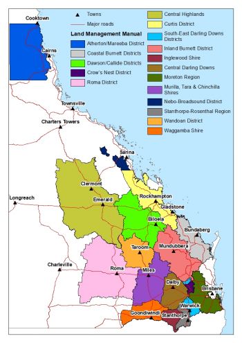

There are 17 land management manuals covering the following areas in Queensland:
- Atherton–Mareeba Districts
- Coastal Burnett Districts
- Dawson/Callide Districts
- Crow’s Nest District
- Roma District
- Central Highlands
- Curtis
- South-East Darling Downs
- Inland Burnett District
- Inglewood Shire
- Central Darling Downs
- Moreton Region
- Murilla, Tara and Chinchilla Shires
- Nebo-Broadsound District
- Stanthorpe-Rosenthal Region
- Wandoan District
- Waggamba Shire
Accessing soil publications
To find these publications, search the:
- Library catalogue – for land management manuals, factsheets and reports.
- Queensland Spatial Catalogue – for the guide to the soil project areas across Queensland, the soil and land resource project boundaries Queensland spatial dataset (shows areas of detailed soil mapping available and provides a connection to soil reports and data), and detailed metadata for specific projects.
- Queensland Globe – for soil mapping and soil site data. Read the step-by-step guide to accessing soils information from the Globe (PDF, 4 MB). This is an interactive tool that displays physical, geographical and spatial data about a particular location in map format.