Preventing and managing erosion
Programs to control erosion in Queensland began in the 1950s and have been very successful.
The 3 main principles to control erosion are to:
- use land according to its capability
- protect the soil surface with some form of cover
- control runoff before it develops into an erosive force.
Land capability
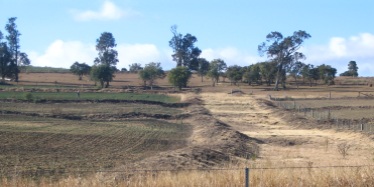
Soil erosion can be avoided by using land within its capability.
The land’s position, soil type and slope determine how vulnerable it will be to erosion. It may not be suitable for agriculture, or suitable only for an activity which limits erosion.
There are a number of resources to help determine how land should be used to avoid erosion:
- for cropping lands—land management field manuals map and describe the land types in many districts and provide advice on land use and management for each soil type. Go to our library catalogue and search for land management field manuals to view manuals available in your region.
- for grazing lands—maps of soils and land types are available for most areas. These give graziers an indication of what soils their property may have and are a useful planning tool. Search for soils maps and reports in your region.
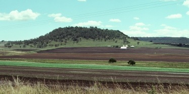
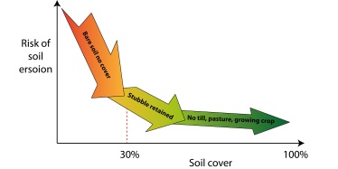
Surface cover and runoff
Surface cover is a major factor to control erosion because it reduces the impact of raindrops falling on bare soils and wind removing soil particles. It also reduces the speed of water flowing over the land.
Erosion risk is significantly reduced when there is more than 30% soil cover. Total cover is achievable for many grazing and cropping systems.
Runoff concentrates as it flows downslope. By the time rivers draining large catchments reach the coast, they are usually just a few hundred meters wide. Even though surface cover encourages runoff to spread, runoff concentration is inevitable.
Coordination across the catchment is important when implementing runoff control measures. Runoff may pass through several properties and cross several roads (sometimes railway lines) as it passes from the most remote part of a catchment to a major drainage line or creek.
Experiment: the importance of cover
The importance of cover was shown in an experiment at Mt Mort, near Ipswich (see table below). In treatment C, where the land was almost bare, 70% of rainfall from a 54mm storm was lost as runoff. The soil loss from this one event was 22 tonnes per hectare. Treatments A and B with higher cover levels had much less runoff, soil and nutrient loss.
It can take thousands of years to form an inch of soil. The depth of soil lost from treatment C from this one storm event may take hundreds of years to replace, provided no further erosion occurs.
| Treatment | A | B | C |
|---|---|---|---|
| Per cent cover | 87 | 69 | 6 |
| Total runoff from storm (mm) | 1.5 | 14 | 38 |
| Per cent of rainfall that ran off | 3 | 26 | 70 |
| Soil loss (t/ha) | 0.03 | 0.3 | 22 |
| Depth of soil lost (mm) | 0.002 | 0.02 | 1.7 |
| Sediment concentration (g/L) | 1.5 | 1.9 | 63 |
| Nitrogen removed (kg/ha) | 0.14 | 1.9 | 15.3 |
| Phosphorous removed (kg/ha) | 0.02 | 0.26 | 4.3 |
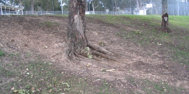
Using trees to control erosion
Trees are often considered to be the universal answer to control soil erosion. Tree roots help prevent landslides on steep slopes and stream bank erosion but they don’t stop erosion on moderately sloping hillslopes.
In forests, the soil surface is usually protected by a layer of mulch from decaying vegetation as well as a variety of surface growing plants. If the soil is bare under the tree canopy from over grazing, vehicles or pedestrians, soil erosion will still occur.
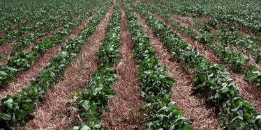
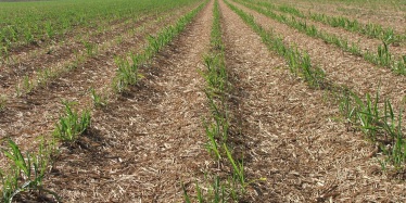
Erosion control in cropping lands
Tillage
Conservation cropping practices that maintain cover on soils include minimum and zero tillage practices. Nowadays during the fallow period, farmers use tillage implements that kill weeds without burying stubble and herbicides to minimise the frequency of tillage.

Contour banks and strip cropping
Runoff concentration is managed by structural measures such as contour banks in upland areas, or strip cropping on floodplains. These systems involve a total change in the way a farm is managed.
Runoff systems must be carefully planned. Flow between properties and across roads and railway lines must be coordinated and suit those affected by the changes.
When runoff water can impact neighbouring properties or infrastructure, land owners are encouraged to discuss with their neighbours and seek professional advice.
Approximately 80% of soil lost as a result of poor cover can be trapped in the paddock by contour banks. The banks channel the runoff at low speed into grassed waterways. Good surface cover between contour banks and in waterways will ensure their stability and dramatically reduce the amount of soil deposited in waterways.
On flood plains, strip cropping is used to spread flood flows rather than allowing it to concentrate.
Green cane harvesting
Another measure that maintains soil cover is green cane harvesting or ‘trash blanketing’. When a cane crop is harvested, the leaves and tops of the cane are left on the ground as a ‘trash blanket’. This protects the soil from erosion by raindrop impact. This practice has been widely adopted in many Queensland cane growing districts.
More information
Read more about managing erosion in cropping lands:
- Erosion control in cropping land
- Soil conservation planning in cropping lands (PDF, 442KB)
- Runoff control measures for erosion control in cropping land
- Maintaining contour banks
- Contour bank specifications
- Controlled traffic farming—soil conservation considerations for extensive cropping
- Soil conservation waterways—planning and design
- Soil conservation waterways—construction and management
- Soil conservation waterways—plants for stabilisation.
Erosion control in grazing lands
Surface cover
Surface cover is the key to erosion control in grazing lands. It prevents erosion by maintaining the soil so it can absorb rainfall.
A well-managed pasture with good cover will ensure that runoff spreads rather than concentrates. Bore drains, tracks, roads, cattle pads and fences concentrate runoff, so careful planning is required to ensure that property improvements are located where they will not contribute to erosion.
The critical level of cover for pastures in tussock grasslands is about 40% cover and 1000 kilograms per hectare of dry grass. Ideally, this level of cover will exist at the beginning of the summer storm season.
The ideal stocking rate is flexible, and stock numbers should match available feed. Regular monitoring of pastures is necessary to achieve this. Long-term weather forecasting, using predictive tools such as the Southern Oscillation Index (SOI), has improved the options available for predicting droughts.
Opportunistic spelling
Opportunistic spelling should also be part of a grazing strategy. A total spell in a good year may be required to allow desirable grasses to recover from past grazing. Grazing pressure can also be managed by locating watering points away from areas vulnerable to erosion.
Fire
Fire is useful for controlling woody weeds but it needs to be managed carefully. Regular burning of pastures will further reduce ground cover and promote runoff and erosion.
More information
Read more about managing erosion in grazing lands:
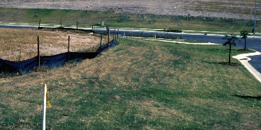
Managing erosion in urban areas
Queensland’s rapidly increasing population and continued economic development require numerous construction projects and activities that expose soils to erosion.
The following approaches will help reduce erosion on development sites:
- disturb minimal area when excavating
- where possible, divert upslope stormwater around the work site and other disturbed areas
- install sediment barriers (e.g. sediment fences or turf buffer strips) downslope of the building site to filter coarse sediments
- restrict vehicle access to one entry point where possible. Gravelling the access point will allow all weather access and minimise erosion.
- connect a temporary or permanent downpipe to a stormwater system before laying the roof
- place all stockpiles on the construction site and behind a sediment barrier
- landscape all bare areas as soon as possible after construction is completed.