Two arrows and a "U" – hydrographic survey mark is heritage listed
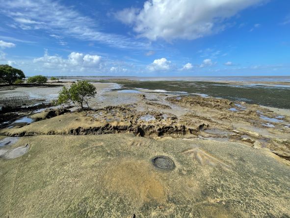
Two arrows and a “U” carved into rock at Sandstone Point overlooking the southern tip of Bribie Island have been entered in the Queensland Heritage Register.
The markings, made in 1867, are a little faded, but remain distinct and are a reminder of Queensland’s significant early European maritime history.
“These rock engravings were a surveying bench mark, carved during the British Admiralty survey of Moreton Bay,” Queensland Heritage Council Chair Leslie Shirreffs said.
“Now heritage listed as the ‘Sandstone Point Hydrographic Survey Bench Mark’, the markings survive as a physical reminder of the early work of Queensland’s maritime surveyors, in particular the survey of Moreton Bay from 1865 to 1868.
“This was important work, crucial to safe navigation in the bay and the development of Brisbane as a port, at a time when the capital and surrounding settlements began to grow.”
The Sandstone Point Hydrographic Survey Bench Mark, on the traditional lands of the Kabi Kabi people, is also known as Leut. Bedwell’s Hydrographic Survey Bench Mark.
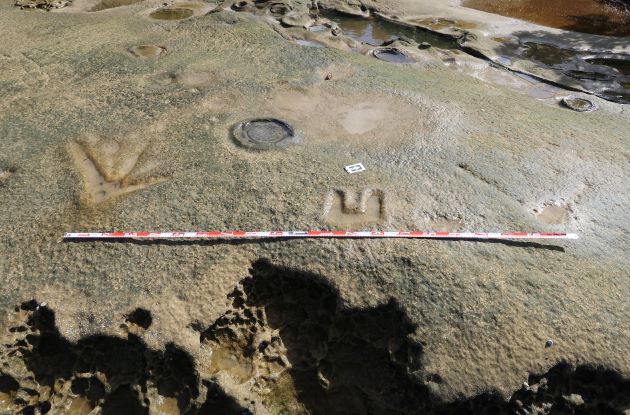
The bench mark comprises two broad arrows flanking a small ‘U’, arranged in a row running northeast to southwest and inscribed into the top surface of a horizontal sandstone ledge.
The marks were originally filled with lead, which is no longer visible, with the arrows pointing southeast and set approximately two metres apart. They are submerged at high tide.
Hydrographic surveying, a highly specialised undertaking in 19th century Britain, mapped the seabed and coastal features to enable safe marine navigation.
It included establishing a triangulation network over survey areas, from the mainland to the sea or adjacent islands, with control points on coastal hills or headlands.
“In 1860, the Queensland Government agreed to share the annual costs of hydrographic surveying, which were then about £3000, with the British Admiralty,” Ms Shirreffs said.
The survey of Queensland waters began in 1862 under Queensland's first Admiralty Surveyor, James Jeffery, with Master (later Navigating Lieutenant, then Staff-Commander) Edward Parker Bedwell succeeding Mr Jeffrey by the time the Sandstone Point bench mark was carved.
The hydrographic survey of Moreton Bay (spanning the traditional lands and seas of the Quandamooka, Kabi Kabi, Gubbi Gubbi, Jagera and Turrbal First Nations peoples) began in 1865.
By 1868, the entire Admiralty survey of Moreton Bay, along with the coastline between Point Danger and a point 6 miles (9.7km) north of Cape Moreton, had been completed.
Ms Shirreffs said the Queensland Heritage Council’s listing of the Sandstone Point Hydrographic Survey Bench Mark on 25 November 2022 showed the variety of places that can qualify for state heritage listing.
“The Queensland Heritage Register contains places many would see as understandable inclusions, such as halls, theatres, homes, commercial and government buildings, and churches.
“But it also contains roads, bridges, railways, mining sites, burial places, public recreation areas, parks and gardens, trees, and now survey marks carved 155 years ago.
“The Queensland Heritage Council noted the Sandstone Point Hydrographic Survey Bench Mark was important surviving evidence of 19th century hydrographic surveys in Queensland waters, retaining a high degree of integrity despite being submerged by tides for a century and a half.”
Any person, community group, organisation or government agency can apply to have a Queensland place heritage listed, with the application to enter the Sandstone Point Hydrographic Survey Bench Mark made by a member of the public.
As well as at Sandstone Point, other confirmed Queensland examples of broad arrow bench marks cut into rocks are at Bessie Point in Cairns Harbour (1878); on the waterfront at Bowen (1887); and at Princess Charlotte Bay in the Flinders group of islands (1899).
The Sandstone Point Hydrographic Survey Bench Mark can be accessed on foot from Bayswater Court, Sandstone Point.