Grazing support programs
Across industry, and the Queensland and Australian governments, there are a number of programs and support tools that help graziers adopt improved farming practices. In addition, the Queensland Government is continuing to invest in tools and research that support graziers to undertake the most appropriate management practices to suit their specific conditions.
On this page
More information is available at land management for graziers.
Support programs and tools for graziers
Good land condition and pasture quality enhance property productivity. Paddocks in good land condition are more sustainable and less susceptible to losing soil through run-off and hence adversely impacting on water quality. Adopting improved practices requires time and effort in the first instance; however they have been proven to achieve long term improvements to productivity and profitability.
Support programs for graziers
Grazing Resilience and Sustainable Solutions (GRASS) program – This Queensland Government program supports graziers in the Burdekin, Fitzroy and Burnett Mary regions to improve poor (C) or degraded (D) grazing land. Graziers are provided with assistance to develop and implement tailored action plans focusing on improving ground cover, pasture quality and enhanced production. The program is funded through the Queensland Reef Water Quality Program and delivered by the Department of Primary Industries (DPI), Burnett Mary Regional Group, Fitzroy Basin Association and NQ Dry Tropics. For more information on the benefits of being involved, visit recognised programs and acknowledged projects.
Extension programs — The Department of Primary Industries (DPI) offers grazing extension services throughout Queensland and has dedicated officers working with graziers in the Reef catchment.
Meat and Livestock Australia’s (MLA), EDGEnetwork® offers practical learning opportunities to help producers gain knowledge and develop necessary skills to improve their livestock enterprises. As part of this program, MLA has developed Grazing Land Management and The Nutrition EDGE courses. The Grazing Land Management course develops grazing management strategies to increase profit and sustainability. Completing this workshop allows graziers to assess the condition of their paddock, understand more about the grazing ecosystem, meet target markets while remaining sustainable in the long-term, and determine the financial impact of grazing management options. The Nutrition EDGE course gives a comprehensive look at ruminant nutrition. The topics covered include minerals and managing deficiencies, pasture growth and quality, and grazing management. For more information about either program, please visit Future Beef or contact MLA at info@mla.com.au or 1800 023 100.
Support tools for graziers
Land management support tools do not provide answers to land management issues. They use the latest technology to provide information for extension officers or graziers to support land management decision making. They are user-friendly products to support graziers in making management decisions across their property—for keeping land in good condition and improving land in poor condition.
Property maps are the simplest and most important tool for property planning. One of the best ways to develop your own property map is by using the free Queensland Globe overlay on a Google Earth base. Property maps may be obtained from a number of sources. Training on how this can be achieved and extended is available through organisations such as NQ Dry Tropics, the Natural Resource Management (NRM) body for the Burdekin catchment.
Breedcow & Dynama is an online software package for graziers, that helps with planning, evaluating and improving the profitability and financial management of extensive beef cattle enterprises.
A limited number of computer mapping workshops are available through AgForce Projects in conjunction with the Fitzroy Basin Association.
Overlaying land type information provides guidance for decisions regarding infrastructure development, such as location of tracks, fences and watering points. Information about land types in your region and management guidelines can be found through Future Beef.
FORAGE is a web-based system which generates and distributes information relating to climate and pasture condition at user-specified locations. These property reports provide maps and information for a specified lot on plan or adjoining lots on plan in Queensland. FORAGE information available for any location in Queensland includes reports on:
- rainfall and pasture
- rainfall and pasture by land type
- ground cover
- regional comparison ground cover
- indicative land type
- foliage projective cover
- rainfall and pasture growth outlook
- regional climate projections
- drought assessment.
In addition, FORAGE also has a report on erodible soils which is currently only available for the Burdekin region.
Watch videos about what FORAGE does, locating agistment paddocks and properties, body condition and managing land condition.
VegMachine® is another tool to help inform land condition assessment and management. It is ground cover monitoring software developed by the Commonwealth Scientific and Industrial Research Organisation (CSIRO) that enables land managers to better monitor changes in their ground cover and landscape health.
Stocktake Plus training package and app can assist with decisions around managing stock numbers to maintain good land condition. It is an easy to use smart phone app with a simple table input facility. This tool will help calculate long-term carrying capacity, which is the average number of animals that a paddock can support over a planning period (5–10 years). Stocktake Plus will also assist with forage budgeting, the practice of balancing the amount of feed available against the feed needed to maintain land condition and meet production targets. Forage budgeting answers two key questions:
- How long will a paddock last when grazed by a defined number of livestock?
- How many livestock can I put into a paddock while still maintaining a desirable level of residual pasture cover?
The FarmMap4D Spatial Hub is an environment for creating, managing, analysing, accessing and sharing digital farm maps to help improve productivity and sustainability.
Controls on chemical use provided by DPI, is also a useful guideline for safe use of agricultural and veterinary chemicals.
Training programs for graziers
Training programs are delivered by government, private companies and regional Natural Resource Management bodies. The one-stop-shop to find local workshops and programs is available through Future Beef.
EDGEnetwork programs, such as Grazing Land Management, developed by Meat and Livestock Australia are delivered throughout Queensland by the Department of Agriculture and Fisheries and other extension providers.
Grazing Land Management (GLM) EDGE workshop helps graziers develop grazing management strategies to increase profit and sustainability. This workshop will help you assess the condition of your paddock, understand more about the grazing ecosystem, meet target markets while remaining sustainable in the long-term and determine the financial impact of grazing management options.
GLM focuses on managing cattle (numbers, types and location) to make the most of pastures while maintaining or improving land condition and biodiversity. It is essential in order to manage nutrition for optimal cattle performance. Managing for climate, wherever possible, also plays a significant role in grazing land management strategies.
Regional Natural Resource Management bodies, such as Terrain, NQ Dry Tropics, Fitzroy Basin Association, Reef Catchments and the Burnett Mary Regional Group frequently run programs to assist farmers and graziers improve their land and water health.
Information about other training programs that might be useful can be accessed through Future Beef.
Sustainable vs unsustainable grazing practices
When properties are not managed sustainably, the economic and environmental impacts are far reaching. Overstocking can run down pasture, which means less infiltration of rainfall, and increased risk of valuable top soil being lost and eroded areas getting worse.

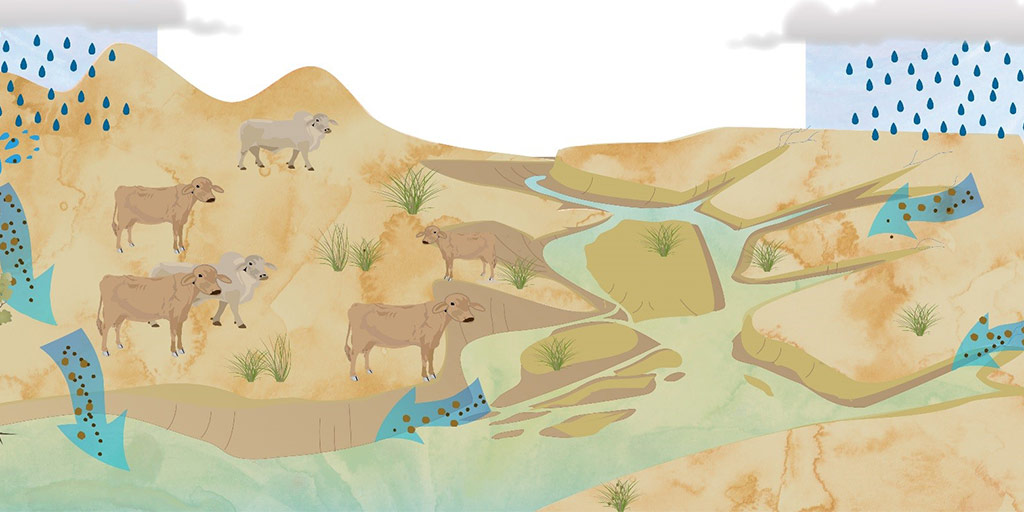
This reduces productivity and means fewer, less healthy cattle on the land. Sediment discharged from rivers in excess of natural erosion rates is a key contributor to the declining health of Great Barrier Reef ecosystems.
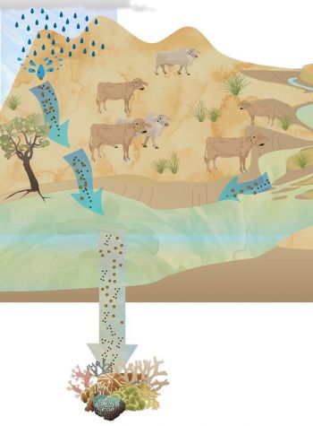

The science behind reducing sediment runoff is clear. When graziers adopt management practices that improve their pasture and ground cover, this minimises soil loss and reduces the risk of sediment run-off to the Reef.
This positively benefits both water quality downstream and cattle production—thereby improving your profitability. Two practices in particular can minimise sediment runoff from your land:
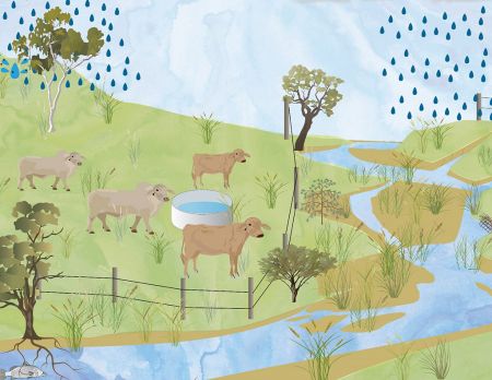
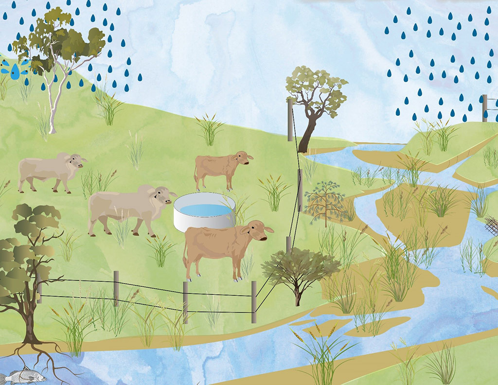
- Maintain good cover of productive, perennial and palatable (3P) pastures throughout the year by setting sustainable stocking rates.
- Redistribute grazing pressure away from areas vulnerable to erosion, such as riparian and frontage country, rilled, scalded and gullied areas and wetlands.

Watch how managing erosion in grazing lands can have a better impact on your property and the Great Barrier Reef.
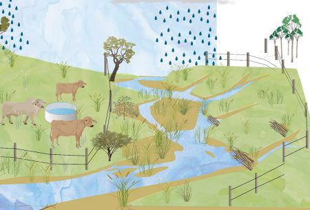
Erosion in grazing lands
Controlling erosion reduces soil loss from properties and sediment flowing to local creeks and rivers.
It includes managing hillslopes, gullies and streambanks
Hillslope erosion can be managed in a number of ways:
Base stocking rates on forage budgets to maintain and improve land condition.
Maintain even grazing with appropriate fencing and water points.
And, rest pasture during the wet season to promote the growth of perennial, palatable and productive grasses, known as 3P grasses.
With good cover of 3P pastures, rain soaks into soil rather than running off and carrying sediment and nutrients into waterways.
The rate of gully erosion can be controlled by managing the catchment above to reduce the run-off that enters the gully. Options such as fences to reduce grazing pressure, stick bundles to trap litter and restoring vegetation to slow water flow may also be applicable.
Streambanks can be maintained by protecting and restoring vegetation, fencing around streambanks and providing watering points off stream for cattle. In some locations, large alluvial gullies and erosion along streambanks may need additional engineering works and expert advice to deal with erosion.
By controlling erosion, the quality of water entering rivers and creeks is improved, as is graziers’ profitability.
Healthy waterways means healthy, productive land and a healthy reef.