The Statewide Landcover and Trees Study (SLATS) monitors woody vegetation extent, and changes to that extent due to clearing and regrowth, using Sentinel-2 satellite imagery as its primary monitoring tool. For more information about SLATS methods, refer to the SLATS methodology.
This report provides clearing data only for the 2023-24 monitoring period, with selected statewide breakdowns included. Regrowth data and additional breakdowns will be added as they become available.
The 2023–24 SLATS reporting period is nominally from August 2023 to August 2024. Data summaries that provide analysis of the clearing data with other key data sets of interest are presented in the report and are accessible as Open Data. Regional summary data for bioregions are also included. The SLATS clearing spatial data are also released as Open Data. For information about how to access these data, refer to SLATS data.
The 2023–24 SLATS clearing report and data are directly comparable with clearing data reported in SLATS reports published from 2018–19 onwards.
The SLATS vegetation management analysis, undertaken by the Department of Natural Resources and Mines, Manufacturing, and Regional and Rural Development, provides a detailed breakdown of the SLATS data in the context of the vegetation management framework.
Key findings
Key findings
In the 2023–24 monitoring period, 274,616ha of woody vegetation was affected by clearing activity. This is a 17% decrease in clearing activity from 2022–23 (332,015ha) and about two-and-half times less clearing activity than was reported in 2018-19.
Of the total clearing activity, 233,253ha (85%) resulted in full removal of the woody vegetation. This is a decrease of 14% in full clearing from 2022–23. The remaining 41,363ha of clearing activity in 2023–24 was partial clearing.
Key findings—clearing activity
Clearing activity in Category X (unregulated) areas accounted for 75% (206,889ha) of the total clearing activity in Queensland, a 19% decrease from 2022–23 (254,647ha). Most of this resulted in full removal of the woody vegetation (190,480ha or 92% of all Category X clearing activity).
About 22% (61,405ha) of the statewide clearing activity was in Category B (regulated remnant) areas—a 13% decrease from 2022–23 (70,799ha). About 62% (or 38,341ha) of the Category B clearing activity resulted in full removal of the woody vegetation.
About 2% (4,876ha) of the statewide clearing activity was in Category C (high-value regrowth vegetation), a similar figure to 2022–23 (4,728ha). Less than 1% (1,249ha) was in Category R (regrowth watercourse area)—a 28% decrease from 2022–23 (1,725ha)
About 1% (3,678ha) of the statewide clearing activity was in areas that have endangered regional ecosystems present, a 21% increase from 2022–23 (3,040ha). About 4% (10,075ha) of the clearing activity was in areas that have of concern regional ecosystems, and 20% (53,620ha) was in areas that have least concern regional ecosystems present, both decreases from 2022–23.
Of the state’s 13 bioregions, the Brigalow Belt (53% or 145,844ha) and Mulga Lands (21% or 57,359ha) together accounted for nearly three-quarters (74%) of the state’s woody vegetation clearing activity. This is consistent with the past four SLATS reports.
Clearing activity in the Great Barrier Reef (GBR) catchment areas accounted for 43% (117,005ha) of the state’s total clearing. This is a decrease of 21% from 2022–23 (147,705ha). About 82% (95,707ha) of the clearing activity in GBR catchments resulted in the full removal of the woody vegetation.
About 86% (235,935ha) of the statewide clearing activity was attributed to the pasture landcover replacement class. Of this, about 90% (213,154ha) was full clearing. A further 5% (14,759ha) of the clearing activity was attributed to forestry and about 60% (8,894ha) of this was partial clearing. Mine activity resulted in around 3% (7,025ha) of the state’s clearing activity, while infrastructure (3,178ha), crop (3,037ha) and settlement (994ha) landcover replacement classes each contributed 1% or less to the state’s total clearing activity.
Statewide overview
Key findings
In the 2023–24 monitoring period, 274,616ha of woody vegetation was affected by clearing activity. This is a 17% decrease in clearing activity from 2022–23 (332,015ha) and about two-and-half times less clearing activity than was reported in 2018-19.
Of the total clearing activity, 233,253ha (85%) resulted in full removal of the woody vegetation. This is a decrease of 14% in full clearing from 2022–23. The remaining 41,363ha of clearing activity in 2023–24 was partial clearing.
Area of clearing activity from 2018–19 to 2023–24.
Full clearing refers to areas which have been converted from woody to non-woody (i.e. less than 10% crown cover remains).
Partial (major) are clearing areas where the woody vegetation has been significantly modified but remains woody (i.e. greater than 10% crown cover remains but more than 50% of the area has been affected by the clearing).
Partial (minor) are clearing areas where some modification of the woody vegetation has occurred, remaining woody (i.e. greater than 10% crown cover remains but less than 50% of the area has been affected by the clearing).
Spatial distribution of clearing activity 2023–24
View larger image
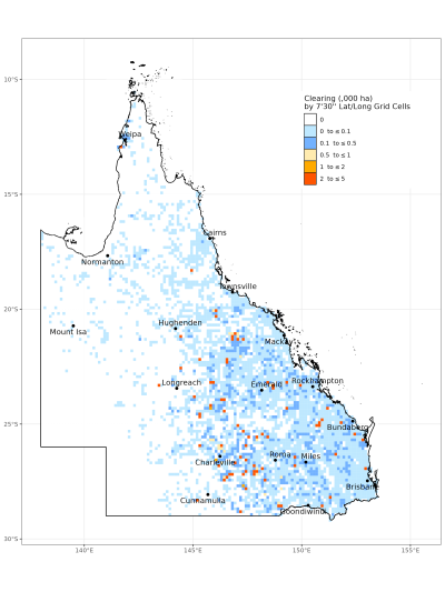
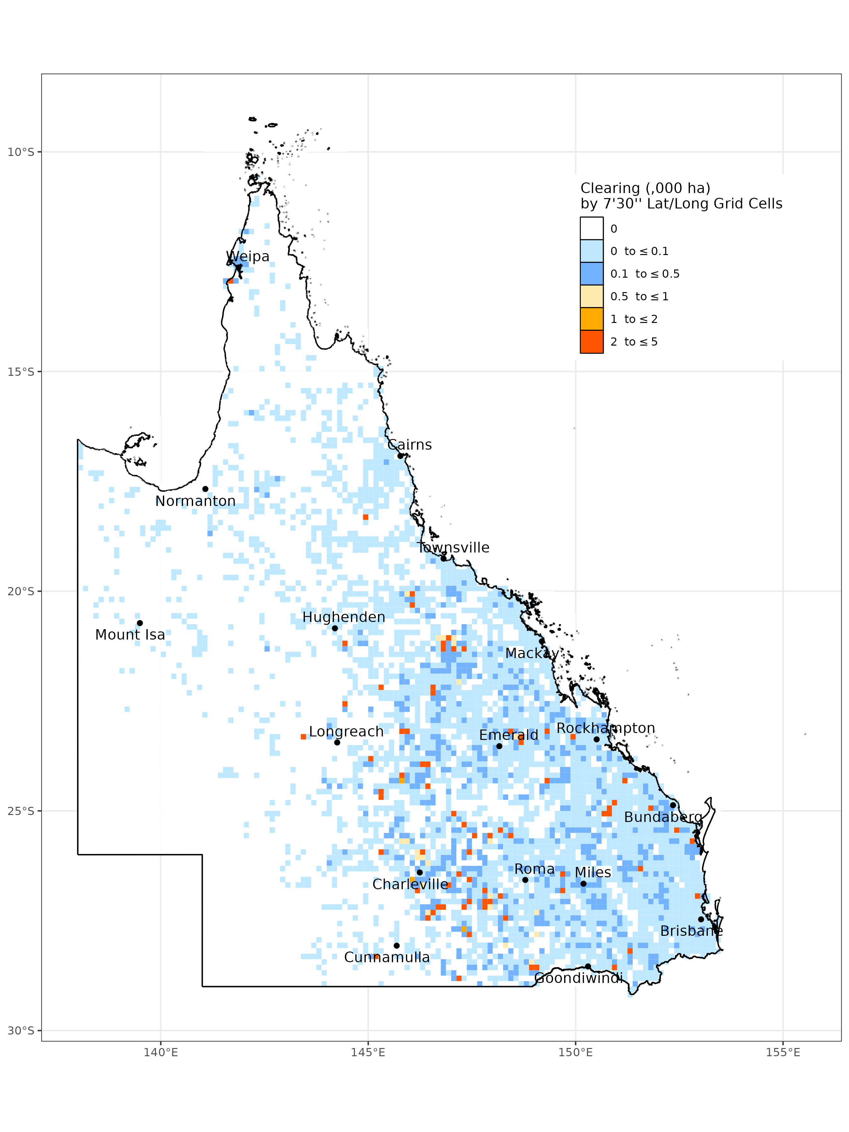
Map of the spatial distribution of all clearing activity mapped in Queensland in 2023–24, summarised by 7’30” latitude/longitude grid cells (each cell is approx. 17,500ha). Red and orange cells indicate that a greater area of clearing activity has occurred at that location.
For more detailed breakdowns of clearing activity in the 2023–24 monitoring period, refer to the Statewide breakdown.
Statewide breakdown
Key findings—clearing activity
Clearing activity in Category X (unregulated) areas accounted for 75% (206,889ha) of the total clearing activity in Queensland, a 19% decrease from 2022–23 (254,647ha). Most of this resulted in full removal of the woody vegetation (190,480ha or 92% of all Category X clearing activity).
About 22% (61,405ha) of the statewide clearing activity was in Category B (regulated remnant) areas—a 13% decrease from 2022–23 (70,799ha). About 62% (or 38,341ha) of the Category B clearing activity resulted in full removal of the woody vegetation.
About 2% (4,876ha) of the statewide clearing activity was in Category C (high-value regrowth vegetation), a similar figure to 2022–23 (4,728ha). Less than 1% (1,249ha) was in Category R (regrowth watercourse area)—a 28% decrease from 2022–23 (1,725ha)
About 1% (3,678ha) of the statewide clearing activity was in areas that have endangered regional ecosystems present, a 21% increase from 2022–23 (3,040ha). About 4% (10,075ha) of the clearing activity was in areas that have of concern regional ecosystems, and 20% (53,620ha) was in areas that have least concern regional ecosystems present, both decreases from 2022–23.
Of the state’s 13 bioregions, the Brigalow Belt (53% or 145,844ha) and Mulga Lands (21% or 57,359ha) together accounted for nearly three-quarters (74%) of the state’s woody vegetation clearing activity. This is consistent with the past four SLATS reports.
Clearing activity in the Great Barrier Reef (GBR) catchment areas accounted for 43% (117,005ha) of the state’s total clearing. This is a decrease of 21% from 2022–23 (147,705ha). About 82% (95,707ha) of the clearing activity in GBR catchments resulted in the full removal of the woody vegetation.
About 86% (235,935ha) of the statewide clearing activity was attributed to the pasture landcover replacement class. Of this, about 90% (213,154ha) was full clearing. A further 5% (14,759ha) of the clearing activity was attributed to forestry and about 60% (8,894ha) of this was partial clearing. Mine activity resulted in around 3% (7,025ha) of the state’s clearing activity, while infrastructure (3,178ha), crop (3,037ha) and settlement (994ha) landcover replacement classes each contributed 1% or less to the state’s total clearing activity.
Area of clearing activity in regulated vegetation management map categories in 2023–24.
Regulated vegetation management maps show the different vegetation categories that are present on a parcel of land. This information helps land managers determine the type of approval needed for vegetation clearing. The categories are as follows:
Category A—vegetation that is subject to compliance notices, offsets and voluntary declarations
Category B—remnant vegetation shown on a regional ecosystem or remnant map as an endangered regional ecosystem, an of concern regional ecosystem or a least concern regional ecosystem
Category C—high-value regrowth vegetation
Category R—regrowth watercourse area
Category X—vegetation that is not generally regulated by the vegetation management laws.
Area of clearing activity in vegetation management classes in 2023–24.
The vegetation management class refers to the current regulated extent of a regional ecosystem. The categories are endangered, of concern and least concern. No VM class refers to areas with no vegetation management class due to no regulated vegetation being present. For reporting here, the highest vegetation management class is used, regardless of the proportion present in regional ecosystem mapping. For example, where a mapped regional ecosystem contains least concern regional ecosystems as the dominant ecosystems, and an endangered regional ecosystem as subdominant, this will be reported as clearing in areas containing endangered regional ecosystems.
Area of clearing activity in landcover replacement classes in 2023–24.
The landcover replacement class is determined as part of the SLATS mapping process. It provides an indication of the purpose for which the vegetation was cleared. Read more about this in SLATS methodology.
Pasture is clearing activity associated with grazing and other general agricultural land management practices—this class includes clearing for pasture, internal property tracks, fence lines or fire breaks.
Crop is clearing activity for cropping or horticulture.
Forestry is clearing activity for timber harvesting in state or privately owned native or exotic (e.g. pine) forests or plantations (where it can be reliably attributed using authoritative data or other ancillary data sources).
Mine is clearing activity for mining activities (including coal seam gas infrastructure).
Infrastructure is clearing activity for utilities such as roads, railways, water storage, pipelines and powerlines.
Settlement is clearing activity for urban development.
Other refers to partial (minor) clearing activity that is not able to be reliably attributed to a landcover replacement class due to the low level of modification associated with these clearing events.
Area of clearing activity in Brigalow Belt from 2018–19 to 2023–24.
Full clearing refers to areas which have been converted from woody to non-woody (i.e. less than 10% crown cover remains).
Partial (major) are clearing areas where the woody vegetation has been significantly modified but remains woody (i.e. greater than 10% crown cover remains but more than 50% of the area has been affected by the clearing).
Partial (minor) are clearing areas where some modification of the woody vegetation has occurred, remaining woody (i.e. greater than 10% crown cover remains but less than 50% of the area has been affected by the clearing).
Area of clearing activity in Brigalow Belt in regulated vegetation management map categories in 2023–24.
Regulated vegetation management maps show the different vegetation categories that are present on a parcel of land. This information helps land managers determine the type of approval needed for vegetation clearing. The categories are as follows:
Category A—vegetation that is subject to compliance notices, offsets, and voluntary declarations
Category B—remnant vegetation shown on a regional ecosystem or remnant map as an endangered regional ecosystem, an of concern regional ecosystem or a least concern regional ecosystem
Category C—high-value regrowth vegetation
Category R—regrowth watercourse area
Category X—vegetation that is not generally regulated by the vegetation management laws.
Area of clearing activity in Brigalow Belt in vegetation management classes in 2023–24.
The vegetation management class refers to the current regulated extent of a regional ecosystem. The categories are endangered, of concern and least concern. No VM class refers to areas with no vegetation management class due to no regulated vegetation being present. For reporting, the highest vegetation management class is used, regardless of the proportion present in regional ecosystem mapping. For example, where a mapped regional ecosystem contains least concern regional ecosystems as the dominant ecosystems, and an endangered regional ecosystem as subdominant, this will be reported as clearing in areas containing endangered regional ecosystems.
Area of clearing activity in Brigalow Belt in landcover replacement classes in 2023–24.
The landcover replacement class is determined as part of the SLATS mapping process. It provides an indication of the purpose for which the vegetation was cleared. Read more about this in the SLATS methodology.
Pasture is clearing activity associated with grazing and other general agricultural land management practices—this class includes clearing for pasture, internal property tracks, fence lines or fire breaks.
Crop is clearing activity for cropping or horticulture
Forestry is clearing activity for timber harvesting in state or privately owned native or exotic (e.g. pine) forests or plantations (where it can be reliably attributed using authoritative data or other ancillary data sources).
Mine is clearing activity for mining activities (including coal seam gas infrastructure).
Infrastructure is clearing activity for utilities such as roads, railways, water storage, pipelines and powerlines.
Settlement is clearing activity for urban development.
Other refers to Partial (minor) clearing activity that is not able to be reliably attributed to a landcover replacement class due to the low level of modification associated with these clearing events.
Channel Country
Clearing activityChannel Country, 2018–19 to 2023–24
Area of clearing activity in Channel Country from 2018–19 to 2023–24.
Full clearing refers to areas which have been converted from woody to non-woody (i.e. less than 10% crown cover remains).
Partial (major) are clearing areas where the woody vegetation has been significantly modified but remains woody (i.e. greater than 10% crown cover remains but more than 50% of the area has been affected by the clearing).
Partial (minor) are clearing areas where some modification of the woody vegetation has occurred, remaining woody (i.e. greater than 10% crown cover remains but less than 50% of the area has been affected by the clearing).
Area of clearing activity in Channel Country in regulated vegetation management map categories in 2023–24.
Regulated vegetation management maps show the different vegetation categories that are present on a parcel of land. This information helps land managers determine the type of approval needed for vegetation clearing. The categories are as follows:
Category A—vegetation that is subject to compliance notices, offsets, and voluntary declarations
Category B—remnant vegetation shown on a regional ecosystem or remnant map as an endangered regional ecosystem, an of concern regional ecosystem or a least concern regional ecosystem
Category C—high-value regrowth vegetation
Category R—regrowth watercourse area
Category X—vegetation that is not generally regulated by the vegetation management laws.
Area of clearing activity in Channel Country in vegetation management classes in 2023–24.
The vegetation management class refers to the current regulated extent of a regional ecosystem. The categories are endangered, of concern and least concern. No VM class refers to areas with no vegetation management class due to no regulated vegetation being present. For reporting, the highest vegetation management class is used, regardless of the proportion present in regional ecosystem mapping. For example, where a mapped regional ecosystem contains least concern regional ecosystems as the dominant ecosystems, and an endangered regional ecosystem as subdominant, this will be reported as clearing in areas containing endangered regional ecosystems.
Area of clearing activity in Channel Country in landcover replacement classes in 2023–24.
The landcover replacement class is determined as part of the SLATS mapping process. It provides an indication of the purpose for which the vegetation was cleared. Read more about this in the SLATS methodology.
Pasture is clearing activity associated with grazing and other general agricultural land management practices—this class includes clearing for pasture, internal property tracks, fence lines or fire breaks.
Crop is clearing activity for cropping or horticulture
Forestry is clearing activity for timber harvesting in state or privately owned native or exotic (e.g. pine) forests or plantations (where it can be reliably attributed using authoritative data or other ancillary data sources).
Mine is clearing activity for mining activities (including coal seam gas infrastructure).
Infrastructure is clearing activity for utilities such as roads, railways, water storage, pipelines and powerlines.
Settlement is clearing activity for urban development.
Other refers to Partial (minor) clearing activity that is not able to be reliably attributed to a landcover replacement class due to the low level of modification associated with these clearing events.
Central Queensland Coast
Clearing activityCentral Queensland Coast, 2018–19 to 2023–24
Area of clearing activity in Central Queensland Coast from 2018–19 to 2023–24.
Full clearing refers to areas which have been converted from woody to non-woody (i.e. less than 10% crown cover remains).
Partial (major) are clearing areas where the woody vegetation has been significantly modified but remains woody (i.e. greater than 10% crown cover remains but more than 50% of the area has been affected by the clearing).
Partial (minor) are clearing areas where some modification of the woody vegetation has occurred, remaining woody (i.e. greater than 10% crown cover remains but less than 50% of the area has been affected by the clearing).
Area of clearing activity in Central Queensland Coast in regulated vegetation management map categories in 2023–24.
Regulated vegetation management maps show the different vegetation categories that are present on a parcel of land. This information helps land managers determine the type of approval needed for vegetation clearing. The categories are as follows:
Category A—vegetation that is subject to compliance notices, offsets, and voluntary declarations
Category B—remnant vegetation shown on a regional ecosystem or remnant map as an endangered regional ecosystem, an of concern regional ecosystem or a least concern regional ecosystem
Category C—high-value regrowth vegetation
Category R—regrowth watercourse area
Category X—vegetation that is not generally regulated by the vegetation management laws.
Area of clearing activity in Central Queensland Coast in vegetation management classes in 2023–24.
The vegetation management class refers to the current regulated extent of a regional ecosystem. The categories are endangered, of concern and least concern. No VM class refers to areas with no vegetation management class due to no regulated vegetation being present. For reporting, the highest vegetation management class is used, regardless of the proportion present in regional ecosystem mapping. For example, where a mapped regional ecosystem contains least concern regional ecosystems as the dominant ecosystems, and an endangered regional ecosystem as subdominant, this will be reported as clearing in areas containing endangered regional ecosystems.
Area of clearing activity in Central Queensland Coast in landcover replacement classes in 2023–24.
The landcover replacement class is determined as part of the SLATS mapping process. It provides an indication of the purpose for which the vegetation was cleared. Read more about this in the SLATS methodology.
Pasture is clearing activity associated with grazing and other general agricultural land management practices—this class includes clearing for pasture, internal property tracks, fence lines or fire breaks.
Crop is clearing activity for cropping or horticulture
Forestry is clearing activity for timber harvesting in state or privately owned native or exotic (e.g. pine) forests or plantations (where it can be reliably attributed using authoritative data or other ancillary data sources).
Mine is clearing activity for mining activities (including coal seam gas infrastructure).
Infrastructure is clearing activity for utilities such as roads, railways, water storage, pipelines and powerlines.
Settlement is clearing activity for urban development.
Other refers to Partial (minor) clearing activity that is not able to be reliably attributed to a landcover replacement class due to the low level of modification associated with these clearing events.
Cape York Peninsula
Clearing activityCape York Peninsula, 2018–19 to 2023–24
Area of clearing activity in Cape York Peninsula from 2018–19 to 2023–24.
Full clearing refers to areas which have been converted from woody to non-woody (i.e. less than 10% crown cover remains).
Partial (major) are clearing areas where the woody vegetation has been significantly modified but remains woody (i.e. greater than 10% crown cover remains but more than 50% of the area has been affected by the clearing).
Partial (minor) are clearing areas where some modification of the woody vegetation has occurred, remaining woody (i.e. greater than 10% crown cover remains but less than 50% of the area has been affected by the clearing).
Regulated vegetation management map category
Clearing activity—regulated vegetation management map categoryCape York Peninsula, 2023–24
Area of clearing activity in Cape York Peninsula in regulated vegetation management map categories in 2023–24.
Regulated vegetation management maps show the different vegetation categories that are present on a parcel of land. This information helps land managers determine the type of approval needed for vegetation clearing. The categories are as follows:
Category A—vegetation that is subject to compliance notices, offsets, and voluntary declarations
Category B—remnant vegetation shown on a regional ecosystem or remnant map as an endangered regional ecosystem, an of concern regional ecosystem or a least concern regional ecosystem
Category C—high-value regrowth vegetation
Category R—regrowth watercourse area
Category X—vegetation that is not generally regulated by the vegetation management laws.
Area of clearing activity in Cape York Peninsula in vegetation management classes in 2023–24.
The vegetation management class refers to the current regulated extent of a regional ecosystem. The categories are endangered, of concern and least concern. No VM class refers to areas with no vegetation management class due to no regulated vegetation being present. For reporting, the highest vegetation management class is used, regardless of the proportion present in regional ecosystem mapping. For example, where a mapped regional ecosystem contains least concern regional ecosystems as the dominant ecosystems, and an endangered regional ecosystem as subdominant, this will be reported as clearing in areas containing endangered regional ecosystems.
Area of clearing activity in Cape York Peninsula in landcover replacement classes in 2023–24.
The landcover replacement class is determined as part of the SLATS mapping process. It provides an indication of the purpose for which the vegetation was cleared. Read more about this in the SLATS methodology.
Pasture is clearing activity associated with grazing and other general agricultural land management practices—this class includes clearing for pasture, internal property tracks, fence lines or fire breaks.
Crop is clearing activity for cropping or horticulture
Forestry is clearing activity for timber harvesting in state or privately owned native or exotic (e.g. pine) forests or plantations (where it can be reliably attributed using authoritative data or other ancillary data sources).
Mine is clearing activity for mining activities (including coal seam gas infrastructure).
Infrastructure is clearing activity for utilities such as roads, railways, water storage, pipelines and powerlines.
Settlement is clearing activity for urban development.
Other refers to Partial (minor) clearing activity that is not able to be reliably attributed to a landcover replacement class due to the low level of modification associated with these clearing events.
Desert Uplands
Clearing activityDesert Uplands, 2018–19 to 2023–24
Area of clearing activity in Desert Uplands from 2018–19 to 2023–24.
Full clearing refers to areas which have been converted from woody to non-woody (i.e. less than 10% crown cover remains).
Partial (major) are clearing areas where the woody vegetation has been significantly modified but remains woody (i.e. greater than 10% crown cover remains but more than 50% of the area has been affected by the clearing).
Partial (minor) are clearing areas where some modification of the woody vegetation has occurred, remaining woody (i.e. greater than 10% crown cover remains but less than 50% of the area has been affected by the clearing).
Area of clearing activity in Desert Uplands in regulated vegetation management map categories in 2023–24.
Regulated vegetation management maps show the different vegetation categories that are present on a parcel of land. This information helps land managers determine the type of approval needed for vegetation clearing. The categories are as follows:
Category A—vegetation that is subject to compliance notices, offsets, and voluntary declarations
Category B—remnant vegetation shown on a regional ecosystem or remnant map as an endangered regional ecosystem, an of concern regional ecosystem or a least concern regional ecosystem
Category C—high-value regrowth vegetation
Category R—regrowth watercourse area
Category X—vegetation that is not generally regulated by the vegetation management laws.
Area of clearing activity in Desert Uplands in vegetation management classes in 2023–24.
The vegetation management class refers to the current regulated extent of a regional ecosystem. The categories are endangered, of concern and least concern. No VM class refers to areas with no vegetation management class due to no regulated vegetation being present. For reporting, the highest vegetation management class is used, regardless of the proportion present in regional ecosystem mapping. For example, where a mapped regional ecosystem contains least concern regional ecosystems as the dominant ecosystems, and an endangered regional ecosystem as subdominant, this will be reported as clearing in areas containing endangered regional ecosystems.
Area of clearing activity in Desert Uplands in landcover replacement classes in 2023–24.
The landcover replacement class is determined as part of the SLATS mapping process. It provides an indication of the purpose for which the vegetation was cleared. Read more about this in the SLATS methodology.
Pasture is clearing activity associated with grazing and other general agricultural land management practices—this class includes clearing for pasture, internal property tracks, fence lines or fire breaks.
Crop is clearing activity for cropping or horticulture
Forestry is clearing activity for timber harvesting in state or privately owned native or exotic (e.g. pine) forests or plantations (where it can be reliably attributed using authoritative data or other ancillary data sources).
Mine is clearing activity for mining activities (including coal seam gas infrastructure).
Infrastructure is clearing activity for utilities such as roads, railways, water storage, pipelines and powerlines.
Settlement is clearing activity for urban development.
Other refers to Partial (minor) clearing activity that is not able to be reliably attributed to a landcover replacement class due to the low level of modification associated with these clearing events.
Einasleigh Uplands
Clearing activityEinasleigh Uplands, 2018–19 to 2023–24
Area of clearing activity in Einasleigh Uplands from 2018–19 to 2023–24.
Full clearing refers to areas which have been converted from woody to non-woody (i.e. less than 10% crown cover remains).
Partial (major) are clearing areas where the woody vegetation has been significantly modified but remains woody (i.e. greater than 10% crown cover remains but more than 50% of the area has been affected by the clearing).
Partial (minor) are clearing areas where some modification of the woody vegetation has occurred, remaining woody (i.e. greater than 10% crown cover remains but less than 50% of the area has been affected by the clearing).
Area of clearing activity in Einasleigh Uplands in regulated vegetation management map categories in 2023–24.
Regulated vegetation management maps show the different vegetation categories that are present on a parcel of land. This information helps land managers determine the type of approval needed for vegetation clearing. The categories are as follows:
Category A—vegetation that is subject to compliance notices, offsets, and voluntary declarations
Category B—remnant vegetation shown on a regional ecosystem or remnant map as an endangered regional ecosystem, an of concern regional ecosystem or a least concern regional ecosystem
Category C—high-value regrowth vegetation
Category R—regrowth watercourse area
Category X—vegetation that is not generally regulated by the vegetation management laws.
Area of clearing activity in Einasleigh Uplands in vegetation management classes in 2023–24.
The vegetation management class refers to the current regulated extent of a regional ecosystem. The categories are endangered, of concern and least concern. No VM class refers to areas with no vegetation management class due to no regulated vegetation being present. For reporting, the highest vegetation management class is used, regardless of the proportion present in regional ecosystem mapping. For example, where a mapped regional ecosystem contains least concern regional ecosystems as the dominant ecosystems, and an endangered regional ecosystem as subdominant, this will be reported as clearing in areas containing endangered regional ecosystems.
Area of clearing activity in Einasleigh Uplands in landcover replacement classes in 2023–24.
The landcover replacement class is determined as part of the SLATS mapping process. It provides an indication of the purpose for which the vegetation was cleared. Read more about this in the SLATS methodology.
Pasture is clearing activity associated with grazing and other general agricultural land management practices—this class includes clearing for pasture, internal property tracks, fence lines or fire breaks.
Crop is clearing activity for cropping or horticulture
Forestry is clearing activity for timber harvesting in state or privately owned native or exotic (e.g. pine) forests or plantations (where it can be reliably attributed using authoritative data or other ancillary data sources).
Mine is clearing activity for mining activities (including coal seam gas infrastructure).
Infrastructure is clearing activity for utilities such as roads, railways, water storage, pipelines and powerlines.
Settlement is clearing activity for urban development.
Other refers to Partial (minor) clearing activity that is not able to be reliably attributed to a landcover replacement class due to the low level of modification associated with these clearing events.
Area of clearing activity in Gulf Plains from 2018–19 to 2023–24.
Full clearing refers to areas which have been converted from woody to non-woody (i.e. less than 10% crown cover remains).
Partial (major) are clearing areas where the woody vegetation has been significantly modified but remains woody (i.e. greater than 10% crown cover remains but more than 50% of the area has been affected by the clearing).
Partial (minor) are clearing areas where some modification of the woody vegetation has occurred, remaining woody (i.e. greater than 10% crown cover remains but less than 50% of the area has been affected by the clearing).
Area of clearing activity in Gulf Plains in regulated vegetation management map categories in 2023–24.
Regulated vegetation management maps show the different vegetation categories that are present on a parcel of land. This information helps land managers determine the type of approval needed for vegetation clearing. The categories are as follows:
Category A—vegetation that is subject to compliance notices, offsets, and voluntary declarations
Category B—remnant vegetation shown on a regional ecosystem or remnant map as an endangered regional ecosystem, an of concern regional ecosystem or a least concern regional ecosystem
Category C—high-value regrowth vegetation
Category R—regrowth watercourse area
Category X—vegetation that is not generally regulated by the vegetation management laws.
Area of clearing activity in Gulf Plains in vegetation management classes in 2023–24.
The vegetation management class refers to the current regulated extent of a regional ecosystem. The categories are endangered, of concern and least concern. No VM class refers to areas with no vegetation management class due to no regulated vegetation being present. For reporting, the highest vegetation management class is used, regardless of the proportion present in regional ecosystem mapping. For example, where a mapped regional ecosystem contains least concern regional ecosystems as the dominant ecosystems, and an endangered regional ecosystem as subdominant, this will be reported as clearing in areas containing endangered regional ecosystems.
Area of clearing activity in Gulf Plains in landcover replacement classes in 2023–24.
The landcover replacement class is determined as part of the SLATS mapping process. It provides an indication of the purpose for which the vegetation was cleared. Read more about this in the SLATS methodology.
Pasture is clearing activity associated with grazing and other general agricultural land management practices—this class includes clearing for pasture, internal property tracks, fence lines or fire breaks.
Crop is clearing activity for cropping or horticulture
Forestry is clearing activity for timber harvesting in state or privately owned native or exotic (e.g. pine) forests or plantations (where it can be reliably attributed using authoritative data or other ancillary data sources).
Mine is clearing activity for mining activities (including coal seam gas infrastructure).
Infrastructure is clearing activity for utilities such as roads, railways, water storage, pipelines and powerlines.
Settlement is clearing activity for urban development.
Other refers to Partial (minor) clearing activity that is not able to be reliably attributed to a landcover replacement class due to the low level of modification associated with these clearing events.
Mitchell Grass Downs
Clearing activityMitchell Grass Downs, 2018–19 to 2023–24
Area of clearing activity in Mitchell Grass Downs from 2018–19 to 2023–24.
Full clearing refers to areas which have been converted from woody to non-woody (i.e. less than 10% crown cover remains).
Partial (major) are clearing areas where the woody vegetation has been significantly modified but remains woody (i.e. greater than 10% crown cover remains but more than 50% of the area has been affected by the clearing).
Partial (minor) are clearing areas where some modification of the woody vegetation has occurred, remaining woody (i.e. greater than 10% crown cover remains but less than 50% of the area has been affected by the clearing).
Area of clearing activity in Mitchell Grass Downs in regulated vegetation management map categories in 2023–24.
Regulated vegetation management maps show the different vegetation categories that are present on a parcel of land. This information helps land managers determine the type of approval needed for vegetation clearing. The categories are as follows:
Category A—vegetation that is subject to compliance notices, offsets, and voluntary declarations
Category B—remnant vegetation shown on a regional ecosystem or remnant map as an endangered regional ecosystem, an of concern regional ecosystem or a least concern regional ecosystem
Category C—high-value regrowth vegetation
Category R—regrowth watercourse area
Category X—vegetation that is not generally regulated by the vegetation management laws.
Area of clearing activity in Mitchell Grass Downs in vegetation management classes in 2023–24.
The vegetation management class refers to the current regulated extent of a regional ecosystem. The categories are endangered, of concern and least concern. No VM class refers to areas with no vegetation management class due to no regulated vegetation being present. For reporting, the highest vegetation management class is used, regardless of the proportion present in regional ecosystem mapping. For example, where a mapped regional ecosystem contains least concern regional ecosystems as the dominant ecosystems, and an endangered regional ecosystem as subdominant, this will be reported as clearing in areas containing endangered regional ecosystems.
Area of clearing activity in Mitchell Grass Downs in landcover replacement classes in 2023–24.
The landcover replacement class is determined as part of the SLATS mapping process. It provides an indication of the purpose for which the vegetation was cleared. Read more about this in the SLATS methodology.
Pasture is clearing activity associated with grazing and other general agricultural land management practices—this class includes clearing for pasture, internal property tracks, fence lines or fire breaks.
Crop is clearing activity for cropping or horticulture
Forestry is clearing activity for timber harvesting in state or privately owned native or exotic (e.g. pine) forests or plantations (where it can be reliably attributed using authoritative data or other ancillary data sources).
Mine is clearing activity for mining activities (including coal seam gas infrastructure).
Infrastructure is clearing activity for utilities such as roads, railways, water storage, pipelines and powerlines.
Settlement is clearing activity for urban development.
Other refers to Partial (minor) clearing activity that is not able to be reliably attributed to a landcover replacement class due to the low level of modification associated with these clearing events.
Area of clearing activity in Mulga Lands from 2018–19 to 2023–24.
Full clearing refers to areas which have been converted from woody to non-woody (i.e. less than 10% crown cover remains).
Partial (major) are clearing areas where the woody vegetation has been significantly modified but remains woody (i.e. greater than 10% crown cover remains but more than 50% of the area has been affected by the clearing).
Partial (minor) are clearing areas where some modification of the woody vegetation has occurred, remaining woody (i.e. greater than 10% crown cover remains but less than 50% of the area has been affected by the clearing).
Area of clearing activity in Mulga Lands in regulated vegetation management map categories in 2023–24.
Regulated vegetation management maps show the different vegetation categories that are present on a parcel of land. This information helps land managers determine the type of approval needed for vegetation clearing. The categories are as follows:
Category A—vegetation that is subject to compliance notices, offsets, and voluntary declarations
Category B—remnant vegetation shown on a regional ecosystem or remnant map as an endangered regional ecosystem, an of concern regional ecosystem or a least concern regional ecosystem
Category C—high-value regrowth vegetation
Category R—regrowth watercourse area
Category X—vegetation that is not generally regulated by the vegetation management laws.
Area of clearing activity in Mulga Lands in vegetation management classes in 2023–24.
The vegetation management class refers to the current regulated extent of a regional ecosystem. The categories are endangered, of concern and least concern. No VM class refers to areas with no vegetation management class due to no regulated vegetation being present. For reporting, the highest vegetation management class is used, regardless of the proportion present in regional ecosystem mapping. For example, where a mapped regional ecosystem contains least concern regional ecosystems as the dominant ecosystems, and an endangered regional ecosystem as subdominant, this will be reported as clearing in areas containing endangered regional ecosystems.
Area of clearing activity in Mulga Lands in landcover replacement classes in 2023–24.
The landcover replacement class is determined as part of the SLATS mapping process. It provides an indication of the purpose for which the vegetation was cleared. Read more about this in the SLATS methodology.
Pasture is clearing activity associated with grazing and other general agricultural land management practices—this class includes clearing for pasture, internal property tracks, fence lines or fire breaks.
Crop is clearing activity for cropping or horticulture
Forestry is clearing activity for timber harvesting in state or privately owned native or exotic (e.g. pine) forests or plantations (where it can be reliably attributed using authoritative data or other ancillary data sources).
Mine is clearing activity for mining activities (including coal seam gas infrastructure).
Infrastructure is clearing activity for utilities such as roads, railways, water storage, pipelines and powerlines.
Settlement is clearing activity for urban development.
Other refers to Partial (minor) clearing activity that is not able to be reliably attributed to a landcover replacement class due to the low level of modification associated with these clearing events.
New England Tableland
Clearing activityNew England Tableland, 2018–19 to 2023–24
Area of clearing activity in New England Tableland from 2018–19 to 2023–24.
Full clearing refers to areas which have been converted from woody to non-woody (i.e. less than 10% crown cover remains).
Partial (major) are clearing areas where the woody vegetation has been significantly modified but remains woody (i.e. greater than 10% crown cover remains but more than 50% of the area has been affected by the clearing).
Partial (minor) are clearing areas where some modification of the woody vegetation has occurred, remaining woody (i.e. greater than 10% crown cover remains but less than 50% of the area has been affected by the clearing).
Regulated vegetation management map category
Clearing activity—regulated vegetation management map categoryNew England Tableland, 2023–24
Area of clearing activity in New England Tableland in regulated vegetation management map categories in 2023–24.
Regulated vegetation management maps show the different vegetation categories that are present on a parcel of land. This information helps land managers determine the type of approval needed for vegetation clearing. The categories are as follows:
Category A—vegetation that is subject to compliance notices, offsets, and voluntary declarations
Category B—remnant vegetation shown on a regional ecosystem or remnant map as an endangered regional ecosystem, an of concern regional ecosystem or a least concern regional ecosystem
Category C—high-value regrowth vegetation
Category R—regrowth watercourse area
Category X—vegetation that is not generally regulated by the vegetation management laws.
Area of clearing activity in New England Tableland in vegetation management classes in 2023–24.
The vegetation management class refers to the current regulated extent of a regional ecosystem. The categories are endangered, of concern and least concern. No VM class refers to areas with no vegetation management class due to no regulated vegetation being present. For reporting, the highest vegetation management class is used, regardless of the proportion present in regional ecosystem mapping. For example, where a mapped regional ecosystem contains least concern regional ecosystems as the dominant ecosystems, and an endangered regional ecosystem as subdominant, this will be reported as clearing in areas containing endangered regional ecosystems.
Area of clearing activity in New England Tableland in landcover replacement classes in 2023–24.
The landcover replacement class is determined as part of the SLATS mapping process. It provides an indication of the purpose for which the vegetation was cleared. Read more about this in the SLATS methodology.
Pasture is clearing activity associated with grazing and other general agricultural land management practices—this class includes clearing for pasture, internal property tracks, fence lines or fire breaks.
Crop is clearing activity for cropping or horticulture
Forestry is clearing activity for timber harvesting in state or privately owned native or exotic (e.g. pine) forests or plantations (where it can be reliably attributed using authoritative data or other ancillary data sources).
Mine is clearing activity for mining activities (including coal seam gas infrastructure).
Infrastructure is clearing activity for utilities such as roads, railways, water storage, pipelines and powerlines.
Settlement is clearing activity for urban development.
Other refers to Partial (minor) clearing activity that is not able to be reliably attributed to a landcover replacement class due to the low level of modification associated with these clearing events.
Northwest Highlands
Clearing activityNorthwest Highlands, 2018–19 to 2023–24
Area of clearing activity in Northwest Highlands from 2018–19 to 2023–24.
Full clearing refers to areas which have been converted from woody to non-woody (i.e. less than 10% crown cover remains).
Partial (major) are clearing areas where the woody vegetation has been significantly modified but remains woody (i.e. greater than 10% crown cover remains but more than 50% of the area has been affected by the clearing).
Partial (minor) are clearing areas where some modification of the woody vegetation has occurred, remaining woody (i.e. greater than 10% crown cover remains but less than 50% of the area has been affected by the clearing).
Area of clearing activity in Northwest Highlands in regulated vegetation management map categories in 2023–24.
Regulated vegetation management maps show the different vegetation categories that are present on a parcel of land. This information helps land managers determine the type of approval needed for vegetation clearing. The categories are as follows:
Category A—vegetation that is subject to compliance notices, offsets, and voluntary declarations
Category B—remnant vegetation shown on a regional ecosystem or remnant map as an endangered regional ecosystem, an of concern regional ecosystem or a least concern regional ecosystem
Category C—high-value regrowth vegetation
Category R—regrowth watercourse area
Category X—vegetation that is not generally regulated by the vegetation management laws.
Area of clearing activity in Northwest Highlands in vegetation management classes in 2023–24.
The vegetation management class refers to the current regulated extent of a regional ecosystem. The categories are endangered, of concern and least concern. No VM class refers to areas with no vegetation management class due to no regulated vegetation being present. For reporting, the highest vegetation management class is used, regardless of the proportion present in regional ecosystem mapping. For example, where a mapped regional ecosystem contains least concern regional ecosystems as the dominant ecosystems, and an endangered regional ecosystem as subdominant, this will be reported as clearing in areas containing endangered regional ecosystems.
Area of clearing activity in Northwest Highlands in landcover replacement classes in 2023–24.
The landcover replacement class is determined as part of the SLATS mapping process. It provides an indication of the purpose for which the vegetation was cleared. Read more about this in the SLATS methodology.
Pasture is clearing activity associated with grazing and other general agricultural land management practices—this class includes clearing for pasture, internal property tracks, fence lines or fire breaks.
Crop is clearing activity for cropping or horticulture
Forestry is clearing activity for timber harvesting in state or privately owned native or exotic (e.g. pine) forests or plantations (where it can be reliably attributed using authoritative data or other ancillary data sources).
Mine is clearing activity for mining activities (including coal seam gas infrastructure).
Infrastructure is clearing activity for utilities such as roads, railways, water storage, pipelines and powerlines.
Settlement is clearing activity for urban development.
Other refers to Partial (minor) clearing activity that is not able to be reliably attributed to a landcover replacement class due to the low level of modification associated with these clearing events.
Southeast Queensland
Clearing activitySoutheast Queensland, 2018–19 to 2023–24
Area of clearing activity in Southeast Queensland from 2018–19 to 2023–24.
Full clearing refers to areas which have been converted from woody to non-woody (i.e. less than 10% crown cover remains).
Partial (major) are clearing areas where the woody vegetation has been significantly modified but remains woody (i.e. greater than 10% crown cover remains but more than 50% of the area has been affected by the clearing).
Partial (minor) are clearing areas where some modification of the woody vegetation has occurred, remaining woody (i.e. greater than 10% crown cover remains but less than 50% of the area has been affected by the clearing).
Area of clearing activity in Southeast Queensland in regulated vegetation management map categories in 2023–24.
Regulated vegetation management maps show the different vegetation categories that are present on a parcel of land. This information helps land managers determine the type of approval needed for vegetation clearing. The categories are as follows:
Category A—vegetation that is subject to compliance notices, offsets, and voluntary declarations
Category B—remnant vegetation shown on a regional ecosystem or remnant map as an endangered regional ecosystem, an of concern regional ecosystem or a least concern regional ecosystem
Category C—high-value regrowth vegetation
Category R—regrowth watercourse area
Category X—vegetation that is not generally regulated by the vegetation management laws.
Area of clearing activity in Southeast Queensland in vegetation management classes in 2023–24.
The vegetation management class refers to the current regulated extent of a regional ecosystem. The categories are endangered, of concern and least concern. No VM class refers to areas with no vegetation management class due to no regulated vegetation being present. For reporting, the highest vegetation management class is used, regardless of the proportion present in regional ecosystem mapping. For example, where a mapped regional ecosystem contains least concern regional ecosystems as the dominant ecosystems, and an endangered regional ecosystem as subdominant, this will be reported as clearing in areas containing endangered regional ecosystems.
Area of clearing activity in Southeast Queensland in landcover replacement classes in 2023–24.
The landcover replacement class is determined as part of the SLATS mapping process. It provides an indication of the purpose for which the vegetation was cleared. Read more about this in the SLATS methodology.
Pasture is clearing activity associated with grazing and other general agricultural land management practices—this class includes clearing for pasture, internal property tracks, fence lines or fire breaks.
Crop is clearing activity for cropping or horticulture
Forestry is clearing activity for timber harvesting in state or privately owned native or exotic (e.g. pine) forests or plantations (where it can be reliably attributed using authoritative data or other ancillary data sources).
Mine is clearing activity for mining activities (including coal seam gas infrastructure).
Infrastructure is clearing activity for utilities such as roads, railways, water storage, pipelines and powerlines.
Settlement is clearing activity for urban development.
Other refers to Partial (minor) clearing activity that is not able to be reliably attributed to a landcover replacement class due to the low level of modification associated with these clearing events.
Area of clearing activity in Wet Tropics from 2018–19 to 2023–24.
Full clearing refers to areas which have been converted from woody to non-woody (i.e. less than 10% crown cover remains).
Partial (major) are clearing areas where the woody vegetation has been significantly modified but remains woody (i.e. greater than 10% crown cover remains but more than 50% of the area has been affected by the clearing).
Partial (minor) are clearing areas where some modification of the woody vegetation has occurred, remaining woody (i.e. greater than 10% crown cover remains but less than 50% of the area has been affected by the clearing).
Area of clearing activity in Wet Tropics in regulated vegetation management map categories in 2023–24.
Regulated vegetation management maps show the different vegetation categories that are present on a parcel of land. This information helps land managers determine the type of approval needed for vegetation clearing. The categories are as follows:
Category A—vegetation that is subject to compliance notices, offsets, and voluntary declarations
Category B—remnant vegetation shown on a regional ecosystem or remnant map as an endangered regional ecosystem, an of concern regional ecosystem or a least concern regional ecosystem
Category C—high-value regrowth vegetation
Category R—regrowth watercourse area
Category X—vegetation that is not generally regulated by the vegetation management laws.
Area of clearing activity in Wet Tropics in vegetation management classes in 2023–24.
The vegetation management class refers to the current regulated extent of a regional ecosystem. The categories are endangered, of concern and least concern. No VM class refers to areas with no vegetation management class due to no regulated vegetation being present. For reporting, the highest vegetation management class is used, regardless of the proportion present in regional ecosystem mapping. For example, where a mapped regional ecosystem contains least concern regional ecosystems as the dominant ecosystems, and an endangered regional ecosystem as subdominant, this will be reported as clearing in areas containing endangered regional ecosystems.
Area of clearing activity in Wet Tropics in landcover replacement classes in 2023–24.
The landcover replacement class is determined as part of the SLATS mapping process. It provides an indication of the purpose for which the vegetation was cleared. Read more about this in the SLATS methodology.
Pasture is clearing activity associated with grazing and other general agricultural land management practices—this class includes clearing for pasture, internal property tracks, fence lines or fire breaks.
Crop is clearing activity for cropping or horticulture
Forestry is clearing activity for timber harvesting in state or privately owned native or exotic (e.g. pine) forests or plantations (where it can be reliably attributed using authoritative data or other ancillary data sources).
Mine is clearing activity for mining activities (including coal seam gas infrastructure).
Infrastructure is clearing activity for utilities such as roads, railways, water storage, pipelines and powerlines.
Settlement is clearing activity for urban development.
Other refers to Partial (minor) clearing activity that is not able to be reliably attributed to a landcover replacement class due to the low level of modification associated with these clearing events.
2023–24 SLATS Clearing Report,
03 Aug 2026,
[https://www.qld.gov.au/environment/land/management/mapping/statewide-monitoring/slats/slats-reports/2023-24-slats-report]
This document is uncontrolled when printed. Before using the information in this document you should verify the current content on https://www.qld.gov.au/environment/land/management/mapping/statewide-monitoring/slats/slats-reports/2023-24-slats-report.