


Surveying history
Surveying has been closely linked to the history of Queensland. Whilst our early surveyors may not be as well-known as explorers such as Burke and Wills, by following in the explorers' footsteps, they opened up Queensland to colonisation. The surveyors of Queensland endured some of the harshest conditions in the world, with tools that were extremely labour intensive. Yet their professionalism under these circumstances laid the groundwork for a world-class land administration system.
‘Since the beginning of recorded history, people have needed to measure and map the world about them. In every scheme and project—from buildings and other structures on land, to pipelines and cables beneath the land and sea, or bridges and transmission lines above it—the surveyor is usually the first person on site and the last to verify that what was done is correct. Surveying is the vital link in the process which transforms ideas into plans, and plans into reality.’ (The Institution of Surveyors Australia, June 1997, Open up Your World)
Surveying: the life
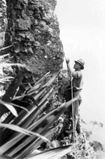
Surveyors in Queensland faced many challenges in the course of carrying out their work. The extreme weather conditions, the harshness of the terrain, the sparseness of population and distances travelled all meant that camps, transport to and from the survey and the need to organise a food supply, were all an integral part of the life of a surveyor in the field.
The early Queensland surveyor faced hardship and adversity, wildlife and fauna which included crocodiles, insect infestations and poisonous plants, and the problem of too much or too little water resulting from the impenetrability of terrain, or drought. These challenges took a heavy toll on the health of early surveyors, their working parties and their animals.
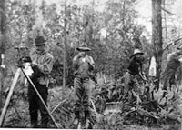
The working life of a surveyor was varied. Working parties often sought assistance from locals and Indigenous guides.
Surveyors too responded to the call for help in war, and because of their surveying skills and ability to work under difficult conditions (as faced in Queensland) they were often recruited to conduct surveys overseas.
Surveying: the profession
A decision in the 1830s to transform Moreton Bay from a penal colony to an area of free settlement helped to usher in new opportunities for the future state of Queensland. To develop the land, the colony needed surveyors to make the first detailed surveys.
The surveying process used was dependent on the information and level of accuracy required. Types of survey included trigonometric surveys for establishing control, feature surveys that referenced watercourses, ranges and other features, and surveys setting out boundaries of land parcels.
Queensland’s first surveyors came from outside the state. To become a surveyor required training and in Queensland this training evolved over time. Professional associations developed to assist surveyors in their professional life.
Survey tools
Conducting a survey required the surveyor to firstly establish his position. From flat-earth models to global positioning systems, the referencing of coordinates has undergone many changes over the years.
Geodetic datums were developed to assist the work of surveyors, cartographers and navigators by using a coordinate reference system to describe geographic positions. Many different datums have been used to frame position descriptions since the first estimates of the earths size were made by Aristotle. Datums have evolved from those describing a spherical earth to ellipsoidal models derived from years of satellite measurements, which are now infinitely more accurate.
Surveying techniques and the tools required to carry out surveys developed hand in hand with technology. Using delicate instruments with precision and accuracy was vital to a successful survey.
The first suppliers of surveying tools in the colony were jewellers and opticians who, at first, imported instruments from Europe and later produced them locally.
Distances were measured with chains and perambulators. Angles were measured with circumferentors and theodolites. In addition, a wide range of tools were used over time to help with the calculations required as part of the surveying process.
Administering land
Before Queensland was declared a state, the land ownership system in the colony of New South Wales was based on the premise that all land belonged to the Crown. This was the colony’s prime source of revenue as any land not required for use by the Crown could be leased or sold to others.
Surveys were critical to identify land parcels and their dimensions and areas. Land sold was referred to as freehold land and administered under the titles registry system, and crown land was administered by a different system based initially on the Commissioners of Crown Land later becoming the Land Administration Board or Commission.
The increasing complexity in administration of land dealings saw the development of more detailed principles, parcels were designated into an administrative area type (e.g. pastoral districts or counties) as settlement increased.
Related links
- Learn about Queensland’s historical surveying processes.
- View images of instruments and equipment used to survey and map Queensland.