


First surveys
Before surveyors arrived in Queensland, explorers such as Captain Logan and botanist Allan Cunningham ventured further west from Brisbane. They paved the way for selectors and squatters to follow and settle the land.
Once the area around the Brisbane settlement had been established, explorers penetrated deeper into the continent opening up territory for new settlers.
Trigonometrical surveys around Brisbane
The Imperial Government made a decision in the 1830s to abandon Moreton Bay as a penal station and open up the area to free settlement. By 1839, most of the convicts had been removed and Governor Gipps had despatched the first three surveyors, Dixon, Stapylton and Warner, to Moreton Bay. They arrived in May of 1839 and began carrying out surveys for the town of Brisbane and surrounding areas. Gipps gave directions that:
‘... the survey shall, for the first time in New South Wales, be conducted on scientific principles by using a theodolite rather than a compass.’ (Governor Gipps 1839, Historical Records of Australia, vol. 20, p. 210.)
This scientific or trigonometrical survey soon commenced with Dixon measuring a base line three miles long on the Normanby Plains near Ipswich.
‘The base line was measured with three deal [pine] rods ten feet long, tipped with brass measured from the Standard Scale. Each rod was located on tripods and set in a perfect straight line...’ (Dixon, R 1840, Field book A/43359, Queensland State Archives)
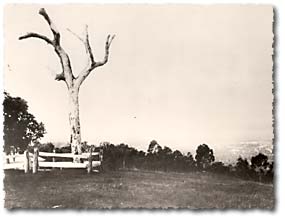
Warner was instructed to clear the mountain tops of their timber. This was so that the angles could be read to the other trig stations. One of the hills being cleared by Warner and his men was on the Herbert Taylor Range. It was here that Warner left a solitary tree to sight on from all the other trig stations.
This station became known as One Tree Hill and later Mt Coot-tha.
In May 1840, Staplyton was killed by Aboriginals while surveying near Mt Lindesay.
In a new district where there were no previous surveys of the land, the surveyors initially spent considerable time on feature surveys. This was to locate the rivers, creeks and ranges, some of which would later become the boundaries of the runs, parishes and counties.
Due to the isolation of these feature surveys and their repetitive nature, Sir Thomas Mitchell, Surveyor General of New South Wales (including what is now Queensland), described the effect on his young surveyors in the following terms:
‘In many cases, has lost me good surveyors, talented young men, from the odious habit of drunkenness, to which they have more than once fallen victim.’ (Mitchell, Sir Thomas 1855, 'Minutes of evidence taken before the Commissioners appointed to inquire into the Surveyor-General's Department', Parliamentary Papers, p. 26.)
As settlement expanded, surveyors were in high demand. They surveyed townships, villages and farms throughout initially south-east Queensland and then over time, over the rest of Queensland.
As a result of the size of the properties (known as runs which were approximately 25 square miles in area), they formed parishes when the areas were opened up for closer settlement.
Trigonometrical survey on the Condamine
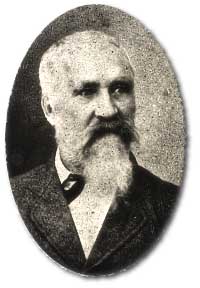
In 1846, James Charles Burnett became surveyor in charge of the Moreton Bay district, replacing Henry Wade. Wade had previously replaced Robert Dixon.
On 1 November 1847, Deputy Surveyor General SA Perry wrote to Burnett. He outlined the requirements for a triangulation survey of the grazing districts beyond the boundaries of the proclaimed counties.
‘In commencing the general survey of your district, you will assume as fixed points such remarkable geographical features as may have been laid down (from data upon which you can rely) in the previous surveys of Mr Dixon and yourself. From these points you will carry a connected series of triangles along the great watershed of the Condamine and the eastern waters, laying down as you proceed, the heads of all the tributaries to the Condamine that have heretofore been placed on the maps as the result only of hasty reconnaissance's...’ (Perry, SA 1847, Out letters, Surveyor-General of NSW Perry to Burnett, microfilm reel 2828, Museum of Lands, Mapping and Surveying, p. 283.)
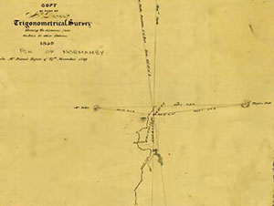
In May of 1849, Burnett measured a base line for his triangulation network. This base line was 2 miles and 10 chains long and was situated midway between Mt Maria and Mt Irving on the Jondaryan Plain near Dalby. The triangulation surveying was carried out between February 1848 and April 1850, but only covered a small area on the south eastern part of the Darling Downs. Burnett used the same 3 deal rods that Dixon had used in 1839.
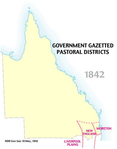
Pastoral expansion
The sequence of pastoral settlement evolved from the south-east corner of the colony in 1842. This continued until the whole of the colony was divided into districts by 1873.
Related links
- Learn about Queensland’s historical surveying processes.
- View images of instruments and equipment used to survey and map Queensland.