


Pastoral run maps
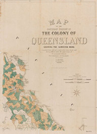
The first pastoral properties were called runs. The word run is an old English term that referred to a large area of land on which sheep and cattle were depastured without the need for a lot of fencing.
How run maps were created
Maps of runs were created from on-ground surveys and in-office assessment based on other survey information.
To create a run map, surveyors first carried out feature surveys of the land (e.g. rivers and ranges). To define a run they also marked trees called reference trees every one half or one mile. Squatters could make application to lease a run using references to these reference trees or features. Over time additional surveys marked and recorded boundaries of runs.
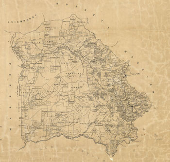
Original run boundary maps
Runs were leased to pastoralists by the state government who collected rent instead of selling the land outright. Run sizes were usually 25 square miles.
The South Kennedy Run map is one of the first series of run maps showing the original surveyed and unsurveyed boundaries of runs. These maps showing property names and locations were an important tool used by the government to help manage their leasehold properties in vast areas of Queensland.
The surveys that were used to create these maps established survey reference points from which good legal descriptions of run boundaries could be written reducing litigation and boundary disputes.
People wanting to take up runs also found these maps useful in finding areas in which they could apply for leases.
Consolidated run boundary maps
From the 1860s the Queensland Colonial Government through the Lands Department introduced acts and legislation that allowed pastoralists to consolidate their various holdings into one large holding. The pastoralist was allowed to keep one half of the large holding on better terms and the other half was taken back by the government. This resumed half was subdivided into smaller blocks raising more revenue for the government and encouraging closer settlement to help satisfy the demand for farming type of land.
The Survey Office created a series of maps that covered most of Queensland to show these consolidations.
Related links
- Learn about Queensland’s historical mapping processes.
- View images of instruments and equipment used to survey and map Queensland.