Cartographers at work
Draftsmen, or cartographers as they became known, used their artistic and technical skills in creating survey plans and maps of aesthetic merit and high standard. There was a sense of pride in creating a permanent representation of their efforts which would endure. In the early days, these draftsmen were allowed to sign their names on maps they had created, adding to their feelings of accomplishment.
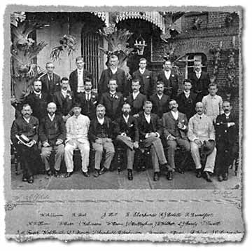
The drafting workforce
Economic depressions had a significant impact on the numbers of draftsmen employed by government and on their wages. For example, in the Depression of the 1890s, the number of draftsmen employed in the Survey Office dropped from 53 in 1889 to 46 in 1899, and the salary for a draftsman dropped from £600 to £400. It was observed by the Surveyor General that previous high standards were maintained during these years because of cheerful exertions of the remaining officers, and the fall-off of land dealings.
The early years of the 1900s also witnessed staff retrenchments. In 1907 the Survey Office was reduced to just 17 draftsmen, of which only 3 were capable of working on stone. Consequently, map production suffered severely. However, because settlement on new land was occurring at a slow pace due to severe drought, there was decreased demand for new maps. The retrenchment scheme was so invasive that even the office of the Surveyor General was abolished early in the decade, although only until 1907.
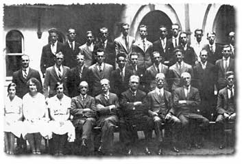
In 1909, 2 young females were appointed to the drafting staff. This was a victory for women of this time:
‘... the natural refinement of their sex should assist them in doing the drawing, writing and colouring of maps with taste and neatness.’ (unknown source)
By 1920, the strength of draftsmen in the Survey Office had increased to 35. This saw a new vigour in map output and many new parish maps and other themed maps were published.
Becoming a draftsman and progression
During the mid-1870s, a system of periodical examinations for draftsmen was introduced.
During the 1920s, the career path for prospective cartographers entering the public service began as a cadet draftsman for a period of 5 years. They then became an assistant draftsman for a further 5 years. After satisfying examiners, the next appointment was as a draftsman. A draftsman then had automatic incremental increases in wages over a 7 year period.
In 1928, a 3 year Certificate Course in Survey Drafting commenced. This was eventually replaced by a 5 year certificate course in 1966.
The early 1970s saw a decrease in the amount of time taken to reach the level of draftsman from 10 to 5 years.
The range of cartographic education courses available in Australia gradually increased. By 1987 it was possible to study cartography, land information, remote sensing and geographical information sciences at all levels. This included certificates and diplomas, undergraduate and master degrees, and PhD.
Professional associations
The Australian Institute of Cartographers (AIC) was established as a public company in September of 1952. This was as a result of all states combining to form a national body. The Queensland Division was inaugurated on 1 January 1962.
The first conference of the Australian Institute of Cartographers was held in 1974.
In 1989, a motion to change the Institute's name to The Australian Institute of Geographic Information Technology was defeated. This was as a result of government, industry and education sectors using like terms.
In 1995, the Australian Institute of Cartographers changed its name to Mapping Sciences Institute, Australia. This professional organisation represents the disciplines of cartography and geo-information dissemination. In 1964, the institute became the Australian member and international representative of the International Cartographic Association, the peak body representing cartography worldwide.
In 2004, the Spatial Sciences Institute (SSI) was formed to offer coverage of the professional disciplines of cartography, mining and engineering, remote sensing and photogrammetry, surveying, and other forms of spatial information. After discussions, the organisations representing cartography and mining elected not to join the SSI. In 2009, this organisation was renamed Surveying & Spatial Sciences Institute.
Related links
- Learn about Queensland’s mapping history.
- View images of instruments and equipment used to survey and map Queensland.