Mapping history
Humans have been drawing maps for thousands of years. As civilisations rose and fell, each brought new understandings and innovations. Maps reflected people's attitudes, beliefs and priorities of the age.
The skills of map making developed as a desirable tool for learning and the spreading of ideas. Before the 19th century map making was considered an art. The secrets of colouring methods and ingredients used were guarded. Maps, apart from information content, were embellished with imaginative illustrations and ornate lettering with emphasis placed on fine hand and brush skills. They were often used as decoration.
Cartography, as map making became known, incorporated many skills. It combined mathematics, geography and the understanding of geological features as well as aesthetics to connect with its reader by fitting with the reader's perceptual patterns. Creating maps involved complex techniques to address the challenge of representing the three dimensional physical world accurately onto a two dimensional surface.
The development of maps in Queensland
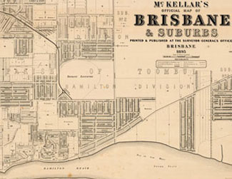
Cartographers have mapped the development of Queensland since before its separation from New South Wales. Some of the first maps produced were cadastral maps. These were developed to assist in administering and expanding the colony.
As the colony grew there was a need for thematic maps, to record details such as school locations and flood extents.
Detailed mapping of Queensland's terrain through topographic mapping did not become a priority until the threat of war in 1913.
Tactile maps or Braille maps were introduced in the early 1980s to cater for the vision impaired.
Life of a cartographer
The early map makers employed their artistic and technical skills to reduce the spatial characteristics of a large area to an observable form, and a work of art.
To ensure the consistent development of the skills needed to produce an accurate map with standardised notations and symbology, periodical examinations to maintain a professional standard were introduced in Australia for cartographic draftsmen.
Over time, the traditional methods employed in map making have been largely replaced by the use of computer technology.
As part of their working life there were often opportunities for the cartographers to display their artistic talents.
Mapping tools
Lettering and scribing required a steady hand and creative style, a quality map required sound information, combined with a visual aesthetic.
Text placement and clarity was an important part of the map making process. The methods of producing text content on a map have undergone many changes. Information created by laborious hand lettering was replaced after World War II by photo-lettering. This new technique greatly improved the speed as well as the uniformity of the final product. Computer generated text was the next significant development.
A key component of a map is a line to depict a boundary, transport route or river. These were all originally drawn by hand however scribing tools became more widely used throughout the 1970s to create these lines. With the development of computers and digital mapping software map production and its delivery has changed dramatically.
Associated mapping activities
Communicating information to a user is the main purpose of a map. Conveying spatial information effectively demands many components.
The modernising of the printing process through invention of lithography in the late 18th century made cartography a more accessible medium. Quicker methods to print many duplicate maps allowed access to a wider audience.
Photography contributed greatly to map reproduction and map quality. Large format cameras were used to reproduce maps for offset lithographic printing.
Related links
- Learn about Queensland’s historical mapping processes.
- View images of instruments and equipment used to survey and map Queensland.