


Surveying the Queensland South Australia border
The survey of the Queensland – South Australian border was first carried out by South Australian surveyor, William Barron, as Queensland did not have a surveyor available at the time. Barron carried the marking of the 141st meridian up to its intersection with the 29th parallel of south latitude (Cameron Corner), and then on to Cooper Creek (90 miles north of that intersection). Barron was forced to return to Adelaide in late 1879 due to ill health.
South Australian surveyors, Augustus Poeppel and assistant Lawrence Wells, took over the survey in January of 1880. The line to the 26th parallel was continued, a distance of 552¼ miles from the river Murray.
Here Poeppel met up with Queensland surveyor, Alexander Salmond. Together they took star observations for latitude using both a transit theodolite and sextant to fix the position of that parallel. They marked the corner with a willow post 12 feet long, which was sunk over an iron bar.
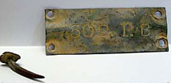
The line was marked by mile posts mounded and trenched. A zinc plate was attached to the posts declaring the distance from the centre of the Murray River.
Poeppel then continued to mark the 26th parallel to the west. He reached the 138th meridian by the end of 1880 and returned to Adelaide in March 1881 due to the prevailing drought conditions. Many hardships were encountered on this survey as the line passed through vast stony, waterless plains, salt lakes and large sand hills. It was thought to be the most inhospitable country in Australia.
While Poeppel was recuperating in Adelaide, the South Australian triangulation survey had reached beyond the border. It was found that when checking the mile posts, they were in error due to the fact that Poeppel's chain was 1 inch too long as a result of wear.