


Identifying salinity
Areas affected by salinity may cover a few square metres to many hectares and fluctuate depending on the contributing factors. It is important to monitor the changes in land salinity in order to assess whether there is a problem.
Indicators of salinity
The indicators below are signs to look out for in identifying a salinity problem.
Changes on the ground
- Ground surface becoming permanently or seasonally waterlogged (or remaining damp) after extended periods of rain.
- Intermittent streams flowing for longer periods.
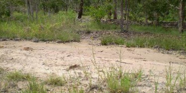
- Areas of bare soil—in worst case, crystals of various salts are present.
- Increase in salt-tolerant plants in an area.
- Rising damp in buildings.
- Deterioration in the quality of groundwater or surface water.
- Livestock rejecting water.
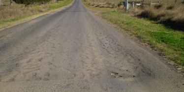
- Road deterioration and crumbling.
- Rising groundwater levels in bores.
Changes in vegetation
- Non-salt tolerant plants being replaced by salt-tolerant species.
- Dieback of vegetation in low-lying areas.
- Failure of plants to germinate or grow.
- Changing pasture composition and reduced diversity caused by the dominance from salt tolerant plants (such as couch grass).
Some land-use activities cause the watertable to rise, which carries salts closer to the surface or into surface water systems—causing salinity problems. These include excessive irrigation and clearing of deep-rooted vegetation (such as native trees and grasses). This can:
- retard or kill crops and vegetation
- increase soil erosion
- increase salt pollution of rivers and dams—harming water supplies for drinking and irrigation
- damage roads, fences, railways and buildings
- harm natural ecosystems.
Evaluating changes in salinity
The National Land and Water Resources Audit developed a set of 4 indicators and protocols to assist in evaluating changes in land salinity. These indicators are:
- groundwater salinity
- depth to groundwater
- baseflow salinity
- location, size and intensity of salt-affected areas.
Factors contributing to salinity
Salinity depends on several factors, the most important being the:
- characteristics of the landscape
- climate
- effects of human activities.
An understanding of water movement associated with the salt-affected area is needed to determine the likely extent of any salinity problem. The sources of these salts are:
- rainfall, which carries low concentrations of salts that have accumulated in landscapes over thousands of years
- weathering and erosion of surface rocks
- groundwater that has soaked through sediments and sedimentary rocks that originally formed in salty marine environments.
The amount of salts which accumulate in soil depends on the properties of the soil and rainfall. For example, clay soils (which occur extensively in inland Queensland) generally have the highest levels of salt.
Susceptible landscapes
Salinity problems develop in response to various combinations of soils, climate, geology, landforms, land use and groundwater characteristics.
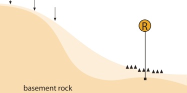
Sensitive landforms usually have some restriction to groundwater flow. This restriction may cause the watertable to rise to near the soil surface, resulting in a discharge area where salts concentrate through evaporation.
The following are geologic features and past patterns of weathering which make some landforms more sensitive, and susceptible, to salting:
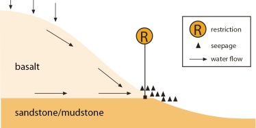
- basalt form—salting can occur where basalt overlies less permeable rock, where regions of variable permeability occur within the basalt, or where the basalt is in contact with adjacent formations
- catena form—discharge areas can occur in the lower slope or at break-of-slope positions, where soils or geologic features restrict water movement. Lower slope soils may be sodium or salt affected
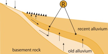
- alluvial fan—discharge areas can occur where subsurface water encounters deep clays or more recent alluvia
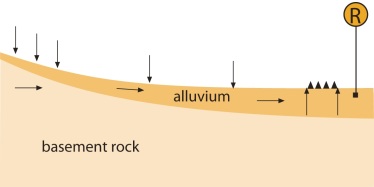
- catchment restrictions (natural)—salting can occur upslope of restrictions that narrow the width or depth of the catchment throat
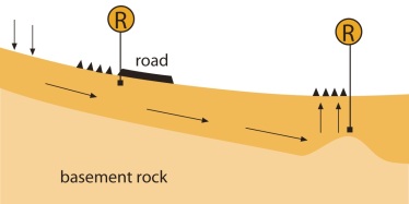
- catchment restrictions (artificial)—salting can occur upslope of roads or stock routes that have compacted soil
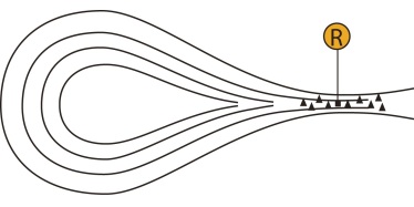
- alluvial valley—salting can occur where the valley is very flat and the hydraulic gradient is very low
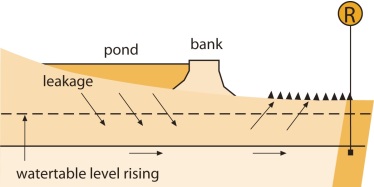
- dams—salting can occur upstream of any dam or downstream of a leaking dam where a less permeable subsoil layer underlies the leak
Read more about landforms associated with salinity in the Salinity Management Handbook (landscape characteristics and salinity mapping section).