


Glossary
- Accelerometer
- Average water level
- Average wave period (Tz)
- Current speed/velocity
- Current direction
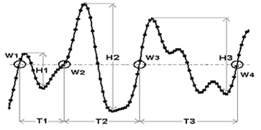
- Maximum wave height (Hmax)
- Peak wave period (Tp)
- Receiver station
- Sea surface temperature
- Significant wave height (Hs)
- Water current
- Wave direction
- Wave height
- Wave monitoring buoy
- Wave period
- Wave record
- Wave spectrum
- Zero up-crossing wave
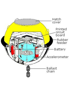
The accelerometer is designed to measure vertical and horizontal motions of the buoy as it follows the movement of the ocean surface.
A calculated zero level that waves can rise above or fall below. This is shown as the horizontal line in the wave record graph.
During a wave record, we use the zero level as a reference to measure the sea surface fluctuations.
To determine these zero levels and to correct for any tidal influence, we use a common statistical method called least squares adjustment.
The average of the zero up-crossing wave periods (in seconds) in a wave record.
Current speed/velocity
Ocean currents are driven by wind, water density differences, and tides. Oceanic currents describe the movement of water from one location to another. We measure them using Acoustic Doppler Current Profilers (ADCP) attached to our wave buoys. Water Currents are measured in meters per second (m/s).
Current direction
Current direction is the direction that the current is flowing, measured in degrees due magnetic north.
For example, 0 degrees being north, 90 degrees being east 180 degrees being south and 270 degrees being west. They’re measured up to 360 degrees.
The height (in metres) of the highest single wave in a wave record.
This is the wave period (in seconds) of those waves that are producing the most energy in a wave record.
Depending on the value of Tp, these waves could either be caused by local wind fields (sea, shorter periods) or have come from distant storms and moved away from their source (swell, longer periods).
The receiver station can be located up to 30km from the wave monitoring buoy.
A receiver unit receives the radio signal transmitted from the wave monitoring buoy and converts it into wave data representing fluctuations of the water surface.
The wave data is then transferred to an onsite computer for storage and processing.
The computer automatically transfers the wave data over the internet to a central computer system (data server) in Brisbane for checking, further processing and archiving.
The sea surface temperature at the wave monitoring buoy, measured from the underside of the hull, in degrees Celsius.
The significant wave height (in metres), defined as the average of the highest one-third of wave heights in a wave record.
Significant Wave Height is frequently used by meteorologists, oceanographers and coastal engineers.
This is the value used by the Bureau of Meteorology in their wave height forecasts.
Water that moves in a horizontal direction, due to many causes, such as different temperatures and prevalent winds.
Water current speed is recorded in meters per second (m/s) by the acoustic current meter attached to the hull of the wave measuring buoys. Water current direction is recorded in degrees (°) relative to magnetic north.
The direction that peak waves are coming from, shown in degrees from true north.
The vertical distance in metres between the crest of a wave and the following trough.
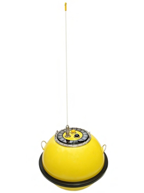
A floating stainless-steel instrument specially designed to follow the movement of the ocean surface to measure wave height and wave direction.
Wave monitoring buoys are moored at selected sites around the Queensland coast, and can range from 0.4m to 0.9m in diameter.
Types of wave monitoring buoy
| WaveRider buoy differences | Triaxys | GPS DWR-G | Mk3 DWR-MKIII | Mk4 DWR4 |
|---|---|---|---|---|
| Waves measured by | Accelerometer | GPS | Accelerometer | Accelerometer |
| Directional or non-directional | Directional | Directional | Directional | Directional |
| Current meter | X | - | - | X |
| Sea surface temperature | X | X | X | X |
| Measuring frequency | 1.28hz | 1.28hz | 1.28hz | 2.56hz |
Wave monitoring buoys can measure wave heights either via an accelerometer or a GPS receiver.
There are 2 types of wave monitoring buoys with accelerometers:
- directional wave monitoring buoys measure wave height, wave direction and wave period along with sea surface temperature
- non-directional wave monitoring buoys are capable of measuring wave height and period only.
Accelerometer wave monitoring buoys use three accelerometers to measure waves:
- 2 fixed horizontal accelerometers to measure accelerations in the north-south and east-west axes
- 1 accelerometer that measures the up-and-down motions (the heave) of the wave monitoring buoy.
The information from the fixed accelerometers is combined with the heave data and compared with an on-board compass to determine the wave directions.
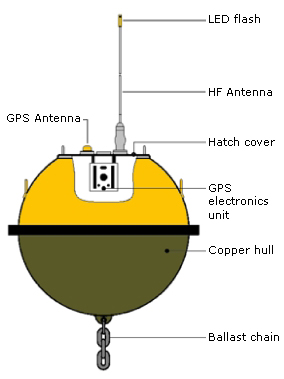
This type of wave monitoring buoy uses the global positioning system (GPS) to determine wave heights and wave directions using the GPS Doppler principle.
The wave period is the time in seconds between one zero up-crossing of the average water level line and the next.
A sample of the wave climate for a given length of time.
Water surface elevations are collected by the wave monitoring buoys and stored at the receiver station computer every half hour, in 26.6 minute-long records.
Wave spectrum, refers to the power spectral density of a wave which is an indication of the amount of energy at a certain frequency in a signal, it is calculated using Welch’s Method.
A wave that crosses the average water level in an upward direction.
This allows identification of the wave crest and trough.
Note: Some organisations define waves in a record using the zero down-crossing method.